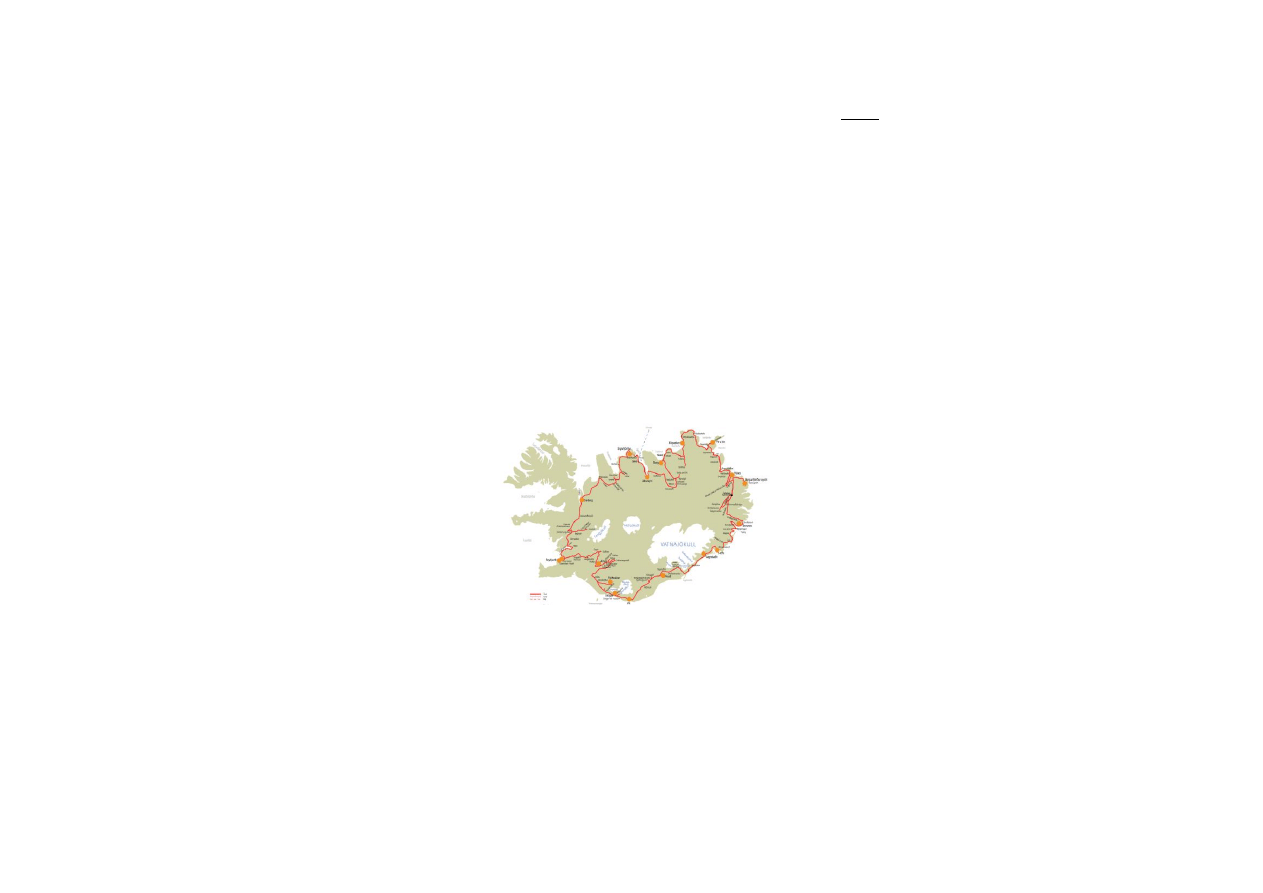
ICELAND GRAND TOUR – 14 days
(excluding Snæfellsnes peninsula and Westfjords)
- starts and ends in the capital Reykjavík
This tour takes 14 days. It covers most parts of Iceland,
except of Snæfellsnes peninsula and the West fjords. In
the northeast, it leaves the ring road and allows you to
discover some of the most remote parts of the country.
There you can enjoy nature at its best. But this tour brings
you to many famous highlights of Iceland as well.
Since day tours are not too long, you have time to enjoy
yourself and to discover the beauty of the country. There
are many different folk museums and museums on birds,
wild life and glaciers on this tour.
You can combine this tour with a visit to Reykjanes
peninsula where the famous Blue lagoon is situated as well
as the International Airport in Keflavík.
Since it describes a circle around the country, you can
easily start this tour from Egilsstaðir, Akureyri or many
other places, not only from Reykjavík.
Tour description
Day 1:
Reykjavík → Sæberg
Sights: Hvalfjörður, Reykholt, Hraunfossar,
Barnafoss, Deildartunguhver, Grábrók
Day 2:
Sæberg → Siglufjörður
Sights: Blönduós, Víðimýri, Glaumbær, Hólar,
Hofsós
Day 3:
Siglufjörður → Akureyri
Sights: Dalvík, Hrísey, Akureyri
Day 4: Akureyri → Berg
Sights: Goðafoss, Mývatn area
Day 5:
Berg → Kópasker/Ytra Lón
Sights: Húsavík, Ásbyrgi, Dettifoss,
Melrakkaslétta
Day 6:
Kópasker/Ytra Lón → Húsey
Sights: Vopnafjörður, Hellisheiði, Jökulsá
Day 7: Húsey → Borgarfjörður eystri
Sights: Lagarfoss, Borgarfjörður eystri
Day 8: Borgarfjörður eystri → Berunes
Sights: Egilsstaðir, Lagarfljót, Hengifoss,
Skríðuklaustur, Valþjófsstaður, Hallormstaðaskógur
Day 9:
Berunes → Höfn/Vagnsstaðir
Sights: Djúpivogur (Papey), Almannaskarð, Höfn
Day 10: Höfn/Vagnsstaðir → Hvoll
Sights: Vatnajökull, Jökulsárlón, Skaftafell,
Núpsstaður
Day 11: Hvoll → Vík/Skógar
Sights: Kirkjugólf, Kirkjubæjarklaustur,
Eldhraun, Fjaðrárgljúfur, Vík
Day 12: Vík/Skógar → Fljótsdalur
Sights: Sólheimajökull, Skógar folk museum,
Skógafoss, Seljalandsfoss
Day 13: Fljotsdalur → Árnes
Sights: Hekla, Búrfellsvirkjun, Stöng,
Þjóðveldisbær, Háifoss, Hjálparfoss
Day 14: Árnes → Reykjavík
Sights: Gullfoss, Geysir, Laugarvatn, Þingvellir,
Reykjavík
Day 1:
- from Reykjavík drive road no. 1 (ring road) to the north
- pass the small town Mosfellsbær; continue until you
reach the fjord Hvalfjörður
- when you reach Hvalfjörður, turn right onto road no. 47
Hvalfjörður
- the name means Whale Fjord, very picturesque
landscape, very quiet area
- The fjord is about 30 km long and up to 84 km deep.
- There used to be a whaling station in Hvalfjörður, it was
closed in 1992, but now it is in use again for a few days
every year.
- Experienced hikers can hike to the highest waterfall in
Iceland, Glymur 210 m. It is at least a two hours hike,
starting from the bottom of the fjord up through the valley
Botnsdalur. Seek information before starting a hike.
- several view points along the road
- There is an interesting photo exhibition at Ferstikla
service station about a submarine station situated in
Hvalfjörður during World War II and on the former whaling
station.
- just after passing the service station Ferstikla turn right
onto road no. 520
- drive over the mountain pass Ferstikluskarð and through
the valley Svínadalur with its three lakes
- continue on road no. 520, cross the valley Skorradalur
Skorradalur
- 28 km long narrow valley, several farms and
summerhouses
- widespread birch growth, extensive forestation
- lake Skorradalsvatn 16 km long, 60 m deep
- continue on road no. 520; turn right onto road no. 50
- turn right onto road no. 518 to get to Reykholt
Reykholt
- one of Iceland’s most important historical sites
- during the Middle Ages rich farm and a center of religion,
culture and politics
- The famous writer and political leader Snorri Sturluson
(1179-1261), author of the Snorra-Edda or prose Edda
lived there. Today you can see a well-preserved thermal

pool from the Middle Ages, where Snorri used to bathe.
Snorri Sturluson was assassinated in a tunnel, which led
from the bath to his house; you can see the entrance to
this tunnel.
- modern church with a cultural center and a special
library for mediaeval studies, changing exhibitions on
mediaeval Icelandic literature and culture
- traditional church from 19
th
century
- statue of Snorri Sturluson by the Norwegian sculptor
Gustav Vigeland, a gift from Norway, unveiled 1947
- the big white building is a former boarding school, built
during the 1930s by Guðjón Samúelsson
- continue on road no. 518 to Hraunfossar and Barnafoss
waterfalls
Hraunfossar
- waterfalls emerging from the junction of porous rock
and basalt, falling into a 1 km long gorge created by the
glacial river Hvítá
- very picturesque scene in the middle of a huge lava field
(Hallmundarhraun)
- There are also walking paths on the lava field, notice
especially the traditional cairns (vörður) on the walking
paths, interesting vegetation.
- Protected area! Do not leave anything; do not take lava
stones or plants with you!
- The name of this waterfall means the “lava falls”.
- service facilities
Barnafoss
- waterfall just upstream from Hraunfossar, just follow the
walking path.
- Legend has it that two children drowned here when they
tried to cross the river walking on a natural rock arch. The
mother of these children had the arch broken down to
protect other families to meet the same fate. You can see
the remains of that arch at the waterfall.
- The name means the “children’s waterfall”.
- if you are looking for refreshments continue on road no.
518 to go to Húsafell
Húsafell
- woodland and recreation area
- swimming pool, service station, restaurant, shop
- drive back, pass Reykholt, turn right onto road no. 50 (to
the north), not far from the junction you will find
Deildartunguhver (to the left)
Deildartunguhver
- most powerful natural hot spring in the world, emits 200
liters of boiling water per second
- very impressive scene, seeing the hot water coming out
of the rock
- many greenhouses, some sell delicious Icelandic
tomatoes at the spot
- today the hot water is also used to heat the houses in
Akranes and Borgarnes
- continue in road no. 50 (to the north), near Varmaland
turn right onto road no. 1
- drive road no. 1 to the north
- not far from Bifröst University College there is the crater
Grábrók (left side of the road)
Grábrókarhraun/Grábrók
- rough lava field, about 3000 years old, covered with
moss and birch growth
- several craters
- Grábrók is one of the craters in Grábrókarhraun, situated
just aside road no. 1
- comfortable walking path up to the top of the crater
- excellent view from the top of Grábrók
- Protected area! Do not leave anything, do not take lave
stones with you!
- continue on road no. 1, drive over highland plateau
Holtavörðuheiði
Holtavörðuheiði
- traditional route between the north and the south of
Iceland
- maximum altitude 400 m
- depending on weather conditions good view towards the
glaciers Eiríksjökull, Langjökull and Hofsjökull
- continue on road no. 1 until you reach the long and
narrow fjord Hrútafjörður
- accommodation is recommended at Sæberg Hostel
- for further information on Sæberg Hostel, Reykir,
Hrútafjörður, 500 Brú –ph.+354-451-0015 / +354-894-
5504
(Distances: Reykjavík-Hvalfjörður (Ferstikla) 77 km,
Hvalfjörður (Ferstikla) - Reykholt 45 km, Reykholt-
Húsafell-Deildartunguhver 70 km, Deildartunguhver-
Grábrók 31 km, Grábrók - Hrútafjörður (bottom) 53 km,
Hrútafjörður (bottom) - Sæberg 15 km; total: 291 km)
Day 2:
- from Sæberg continue on road no. 1, leaving the fjord
Hrútafjörður
- drive road no. 1 to the east
Blönduós
- small town, pop. 1000, living on agriculture, transport,
trading
- situated at the mouth of the river Blanda built on both
sides of the river
- very interesting modern church, built in the years 1981-
1985
- all necessary service available, bank, shops, gas station,
restaurant
- nice recreation area on an island in the glacial river
Blanda, worth to stop and go for a walk (you can see it
from the gas station)
- continue on road no. 1, driving through the valley
Langidalur and over the pass Vatnsskarð
Arnarstapi
- coming down the mountain pass Vatnsskarð you should
stop at the memorial for Stephan G. Stephansson and
enjoy the views on the fjord Skagafjörður
- Stephan G. Stephansson (1853-1927) was an Icelandic
farmer and poet who lived in this area before leaving the
country to settle in USA and Canada, he was called the
poet of the Rocky Mountains
- many farmers and poor people from the Skagafjörður
area emigrated to Canada and the USA in the late 19th
and early 20th century, forming the community of the
West-Icelanders in Canada (especially in Manitoba)

- continue on road no. 1
- before getting to Varmahlíð, you can find the church of
Víðimýri to the right of road no. 1
Víðimýrikirkja
- traditional turf church from 1834
- one of the most beautiful turf churches still existing in
Iceland
- very good example of traditional Icelandic architecture
- local guide, leaflets, postcards at the spot
- continue on road no. 1, turn left on to road no. 75,
passing the village Varmahlíð to get to Glaumbær
Glaumbær
- very interesting open air and folk museum, former
parsonage and wealthy farm
- one of the few remaining Icelandic turf farms, oldest
parts of it are from the 18th century
- Beside the turf farm, there are buildings from the 19th
and early 20th century, including a church and a former
school for housekeepers.
- Take your time; there are many things to explore and to
learn about everyday life in Iceland.
- There is a very nice café in a cozy old-fashioned tearoom
where you can get traditional Icelandic cakes and other
local snacks.
- for further information on Glaumbær museum contact
ph.+354-453-6173
- from Glaumbær drive back to get onto road no. 1, turn
left, heading east
- after a short while, turn left again onto road no. 76 in
direction to Hofsós
- before getting to Hofsós, turn right onto road no. 767 to
get to Hólar in the valley Hjaltadalur
Hólar
- former bishopric (1106-1998), most important historical
site in northern Iceland
- religious and educational centre from the 12th until the
18th century
- it was the site of Iceland’s first printing press
- in 1584 the first complete Icelandic Bible was printed
here
- the last Catholic bishop, Jón Arason, who resisted the
Reformation, was beheaded at Skálholt in fall 1550
- church, built 1763 of local red sand stone, oldest stone
building in Iceland
- church tower built in the 1950s
- get a local guide to tell you about the history and all the
interesting pieces inside the church as well as the replica
of a wooden building, Auðunarstofa, from the Middle Ages
- today home to the Agricultural College and Hólar
University, teaching aquaculture and fish biology, equine
sciences and rural tourism
- during the summer season, there are exhibitions on local
history at the University
- nice hiking area
- drive back and turn right onto road no. 76, heading
north to Hofsós
Hofsós
- village, situated on the eastern shores of Skagafjörður,
pop. 200
- former trading centre and harbor for
- very interesting Icelandic Emigration Centre
(Vesturfarasetrið) with exhibitions on emigration to
Canada and the USA in the late 19th century, worth a visit
- for further information on Vesturfarasetrið contact
ph.+354-453 7935
- nice harbor, the exhibition is situated here, as well as
Pakkhúsið, a wooden warehouse from the 18th century,
now preserved by the National Museum
- continue on road no. 76 and 793 to reach Siglufjörður
Siglufjörður
- fishing town, 1600 inhabitants
- protected against avalanches by two walls (18 and 14 m
high)
- very interesting Herring Era Museum, Iceland’s largest
maritime museum
- The Boat House recreates the town’s bustling harbor of
the 1950s, with many old fishing boats at the dock. During
the years of the so called “herring adventure”, a gold rush-
like atmosphere settled over the town, leading to
Siglufjörður been dubbed the "Atlantic Klondike"
- for further information on the herring museum contact
ph.+354 467 1604
- accommodation recommended at Siglufjörður Hostel
- for further information on Siglufjörður Hostel, Aðalgata
10,580 Siglufjörður –ph.+354 467 1506
(Distances: Ósar – Blönduós 68 km, Blönduós – Glaumbær
64 km, Glaumbær – Hólar 50 km, Hólar – Siglufjörður 87
km; total: 269 km)
Day 3:
- from Siglufjörður drive road no. 793 and 82 to get to
Ólafsfjörður
Ólafsfjörður
- town, 1000 inhabitants
- depending on fishing and fish processing
- local hot springs are used for house heating
- continue on road no. 82
Dalvík
- former fishing village on the western shores of the fjord
Eyjaförður, 1400 inhabitants
- from you have nice views on Hrísey island
- magnificent mountain peaks surround the village
- departure point for the ferry to Grímsey
- whale watching, folk museum, swimming pool
Hrísey
- flat island at the mouth of the fjord Eyjafjörður
- reached by ferry from Ársskógarsandur (10 km south of
Dalvík)
- picturesque village with 200 inhabitants
- interesting for bird watchers (arctic tern, eider ducks,
ptarmigans, golden plover), hiking trails
Akureyri
- so called capital of the North, situated in the narrow fjord
Eyjafjörður
- trading place since 1602, population today 16.000

- interesting sites: botanical garden, modern church by the
architect Guðjón Samúelsson, sculpture “The Outlaw” by
Einar Jónsson, Nonnahús (museum in memory of Jón
Sveinsson, author of children books, for example “Nonni
and Manni”), harbor, folk museum, museum on natural
history
- restaurants, cafés, shops, art galleries etc. in the center
of the town, swimming pool, all year Christmas shop
- tourist information, guided tours by bus, boat and jeep
- airport
- for further information on museums, exhibitions etc.
contact ph.+354-460 1000
- accommodation recommended at Akureyri Hostel
- for further information on Akureyri Hostel, Stórholt 1
603 Akureyri –ph.+354-462-3657 / +354-894-4299
(Distances: Siglufjörður-Ólafsfjörður 62 km, Ólafsfjörður-
Akureyri 61 km; total: 123 km)
Day 4:
- from Akureyri drive road no. 1, heading east
Goðafoss
- very impressive waterfall on the river Skjálfandafljót
- Icelandic Sagas tell that back in the year 1000, when the
parliament had decided that Icelanders should adopt the
Christian religion, the law-speaker Þorgeir
Ljósvetningagoði threw his pagan idols into the river. After
that the waterfall was named the “waterfall of the idols” or
gods.
- walking paths, lovely moss and birch growth, please be
careful not destroying it
- cafeteria, shop and service
- continue on road no. 1 to reach the Mývatn area
Mývatn
- beautiful shallow lake in a region of volcanic activity and
geothermal heat
- during the summer a paradise for ducks and other birds,
average number of 50000 pairs of ducks of 15 species
- very good trout fishing
- extremely beautiful surrounding area, covered with lava
and growth
- interesting geological phenomena like pseudo craters,
lava caves, hot mud and steam springs, canyons etc.
- the name means “lake of the midges”, during the
summer swarms of midges can make life unpleasant here,
but these midges do not bite
- several service stations and restaurants around the lake
- here are a few suggestions for spending the day:
Reykjahlíð
- church and former parsonage, today a small village of
200 inhabitants
- service, restaurant, bank, supermarket, shop
- In the year 1829, the church was threatened by a
volcanic eruption but miraculously the flow of lava stopped
just a few meters from the church. A modern church was
built on the same site in 1972.
Jarðböðin
- very interesting: “Jarðböðin”
- The Mývatn Nature Baths, opened in 2004, are an
outstanding attraction, offering excellent bathing facilities
in an outdoor lagoon whose temperature is 38-40
o
C
- service and information center, cafeteria
- for further information contact ph.+ 354-464-4411
Námafjall
- mountain south of the pass Námaskarð, former sulfur
mine, the east side of the mountain is all covered by signs
of geothermal heat
- impressive bubbling mud pools, steam vents, hot boiling
springs and fumaroles, distinctive stench of sulfur
everywhere
- there are roped-off paths, please do stick to those paths,
it is extremely dangerous to walk around in this area, the
surface material is fragile and the ground is extremely
hot
Krafla and Víti
- cone-shaped volcano north of Námafjall, but also a
system of fissures
- considerable geothermal heat on the west side of Krafla
- Geothermal Power Station, build in 1984, later extended
- The crater Víti is situated nearby Krafla, its name means
“hell” in Icelandic
Skútustaðir
- famous for a number of pseudo craters, formed by gas
explosions when hot lava flew into the waters, looking like
circular craters or small islands
- protected area, please do not leave the walking paths
and close the gates behind you
- service, shop, cafe
Dimmuborgir
- quite unique recreation area
- valley filled up with bizarre lava formations, caves, holes
and pillars.
- protected area, very sensible birch growth
- several marked walking paths, don not leave the roped
off routes, you can easily get lost in this labyrinth of dark
lava rocks
- newly built service and information centre at the
entrance, cafeteria
- accommodation recommended at Berg Hostel
- from lake Mývatn drive road no. 87 to the north, when
you reach road no. 85 turn left and after a short while
right onto road no. 852 to find Berg
- for further information on Berg Hostel, Sandi, Aðaldal,
641 Húsavík –ph.+354-464-3777
(Distances: Akureyri – Goðafoss 50 km, Goðafoss –
Mývatn (Reykjahlíð) 53 km, Mývatn (Reykjahlíð) – Berg
Hostel 47 km; total depends on what sights you choose at
Mývatn)
Day 5:
- from Berg Hostel drive road no. 852 and turn left onto
road no. 85, drive north to get to Húsavík
Húsavík
- nice small town, situated in the bay of Skjálfandafljót,
population 2500
- former fisher town with excellent natural harbor
conditions
- populating now mostly living on service and tourism
- schools, hospital, centre of higher education, banks etc.
- In Húsavík the first Icelandic whale watching tours
started in the early 90’s

- really interesting professional museum and exhibition on
whales and former whaling in Iceland (all the way back to
the Middle Ages), contact ph.
+354 414 2800
- Whale watching recommended! There are different
companies offering whale watching in Húsavík. A trip takes
at least 3 hours.
- church, restaurants, cafés, shops, swimming pool, all
services near by the harbor
- hiking trails along the shore, up to Húsavík mountain
(where you will find a surprising hot water bath), around
the small lake Botnsvatn
- hot springs and geothermal heat
- drive road no. 85 on Tjörnes peninsula
- drive over the bridge at Lón and continue to get to
Ásbyrgi
Ásbyrgi
- U-shaped valley, surrounded by dark cliffs up to 90 m
high
- Legend has it that this is the footprint of the horse
Sleipnir. It had eight legs and was the horse of the Norse
god Odin.
- Geologists think that Ásbyrgi was shaped by enormous
glacier floods coming underneath the glacier Vatnajökull.
- protected area, long and short walking and hiking trails,
information on nature history of the area provided in
brochures and on information tablets
- small romantic lake “Botnstjörn”, home to the lovely
green-winged teal (duck)
- service, shop, cafeteria just outside the area, near by the
road
- coming from Ásbyrgi continue on road no. 85, cross the
bridge over the river Jökulsá á Fjöllum, just after the
bridge turn right
- drive road no. 864 to get to Dettifoss
- Please have in mind that not all vehicles are suitable for
driving on highland roads!
- Road no. 864 is closed during the winter season and
early summer if conditions are very bad.
- Please always get information on road and weather
conditions before driving highland roads contact ph.+354-
522 1000
Dettifoss
- one of the most impressive waterfalls in Iceland and
claimed to be the most powerful waterfall in Europe
- although just 45 m high it dispatches 500 m3 water per
second, since this water comes from a glacier it is of dark
color
- walk from parking to the waterfall takes at least 20
minutes, please be careful, and do not step out of the
marked trails
- drive back north on road no. 864, turn right onto road
no. 85 (in direction to Kópasker)
- accommodation is recommended at Kópasker Hostel or
Ytra Lón Hostel
Kópasker
- small village in the fjord Öxarfjörður, pop. 140, harbor
since 1879, pier for oceangoing ships
- In 1976, the epicenter of a very severe earthquake was
out in the fjord Öxarfjörður; the earthquake caused
damage in the village and the harbor.
- accommodation is recommended at Kópasker Hostel
- for further information on Kópasker Hostel, Akurgerði 7,
670 Kópasker –ph.
+
354-4652314 / 8612314
- if you are going to stay at Ytra Lón Hostel, continue on
road no. 85
Melrakkaslétta
- peninsula between Öxarfjörður and Þistilsfjörður
- all flat low land with a lot of lakes and tarns, former
farming area, today mostly abandoned
- eider duck and seal colonies along the coast
- here you are very near the Arctic Circle
Raufarhöfn
- northernmost village in Iceland, pop. today 340, situated
on the east of the plain Melrakkaslétta
- church designed by the most influential Icelandic
architect, Guðjón Samúelsson
- in the 50’s, during the so called “herring years”, the
harbor underwent extensive improvements; piers were
build to make it possible to land great amounts of herring
- during the “herring adventure” thousands of people
came to Raufarhöfn to help landing, salting and processing
the herring
Þistilsfjörður
- fjord or bay between the peninsula Langanes and the
plain highlands of Melrakkaslétta
- a landscape with low hills and valleys with many rivers
running towards the sea
- former an area with several farms on the moors farther
inland
Þórshöfn
- small village, pop. 390, situated at the fjord Þistilsfjörður
- occupation: fishing, fish-processing, trading, good harbor
- from Þórshöfn it is not far to Ytra Lón Hostel (14 km),
drive road no. 869 to get there
- for further information on Ytra Lón Hostel, Langanes,681
Þórshöfn –ph.+354-468-1242 / +354-846-6448
(Distances: Berg-Húsavík 22 km, Húsavík-Ásbyrgi 67 km,
Ásbyrgi-Dettifoss 27 km, Dettifoss
Kópasker 58 km, Kópasker-Raufarhöfn 54 km, Raufarhöfn-
Þórshöfn 64 km, Þórshöfn-Ytra Lón16km;
total: 174/308 km)
Day 6:
- coming from Kópasker, continue as described the day
before, pass Raufarhöfn and Þórshöfn
- coming from Ytra Lón, drive back to Þórshöfn
- drive road no. 85 across the mountain moore
Brekknaheiði (highest altitude 200 m) and along the coast
line of Langanesströnd
- not far from Skeggjastaðir you can see the rock Stapi
rising straight out of the sea
- at Skeggjastaðir you could visit the church, built 1845
Vopnafjörður
- nice small Village (pop. 500), former important trading
post
- occupation: trading, fishing, fish-processing, farming
- very good natural harbor
- swimming pool in Selárdalur, folk museum, service
- continue on road no. 85, turn left onto road no. 917
- now you have the sea to your left and the mountain
ridge Smjörfjöll to you right
- if you don’t want to drive over the mountain ridge, you
can choose driving road no. 85 to the south and then road

no. 1 to the east (Möðrudalsöræfi), you will get to the
same bridge over the river Jökulsá á Brú
Smjörfjöll
- mountain ridge between Vopnafjörður and Jökulshlíð
- highest point 1251 m, very steep and rocky on the side
of Vopnafjörður
- little vegetation, rough and “cold” landscape
- there can be snowdrifts also during the summer season
Hellisheiði
- mountain road across the highland between Vopnafjörður
and Jökulshlið
- only open for traffic during the summer season
- be very careful in bad weather conditions, it can be very
foggy up there
- astonishing views, breathtaking landscape
- after having crossed Hellisheiði you get into the valley
Jökulshlíð, now you need to drive south because Húsey is
on the other side of the river, continue on road no. 917
- when you reach road no. 1, turn left onto it and just
after the bridge again left onto road no. 925 and 926 to
get to Húsey
Jökulsá á Dal or Jökulsá á Brú
- once one of the biggest glacial rivers in Iceland, now
very much changed because of the Kárahnjúkar power
plant
- as all glacial rivers it carried a lot of sand, clay and
stones, 112 tons of this material flooded into the bay of
Héraðsflói every day, now it often is an almost clear fresh
water river
- 1994 a modern bridge was finished, “Jökulsábrú”, 119 m
long, there is a view point at the eastern edge of the
bridge with a good view into the gorge, 70 m wide and 40
m deep
- accommodation is recommended at Húsey Hostel
- for further Information on Húsey Hostel, Fljótdalshérað,
701 Egilsstadir ph.+ 354-4713010 /847 8229
(Distances: Þórshöfn-Vopnafjörður 70 km, Vopnafjörður –
Jökulsá (bridge) 69 km, Jökulsá (bridge) – Húsey 29 km)
Day 7:
- from Húsey drive road no. 926 to the south, turn left
onto road no. 927, drive in direction to Kirkjubær (to the
north), at Lagarfoss cross the river
Lagarfoss
- waterfall in the river Lagarfljót, devided in two parts
- hydro power station
- bridge over the dam of the power station
- turn left onto road no. 94 (Borgarfjarðarvegur), the road
not Borgjarfjörður eystri
Borgarfjörður eystri
- one of the most remote places in Iceland, to get to the
fjord you have to drive over a mountain pass with steep
roads and serpentines, there are several viewpoints along
this road
- Borgarfjörður eystri is a short, wide fjord, very grassy
and fertile; magnificent colorful mountains of rhyolite and
basalt.
- the village Bakkagerði is situated in the fjord, population
150, living on fishing and service
- The famous Icelandic painter Jóhannes Kjarval (1885-
1972) was born in Borgarfjörður eystri, you can find an
exhibition on him in the community center, also there is
an altarpiece painted Kjarval in the local church.
- many hiking trails, good written information at the spots
- at the harbor a little outside the village there are
excellent bird watching conditions, especially puffins
- near the center of Bakkagerði there is a picturesque
rock, called the rock of elves, Álfaborg, it is believed that
elves live in this rock, walking path around it
- accommodation is recommended at Borgarfjörður
eystri Hostel
- for further information on Borgarfjörður Eystri Hostel,
Ásbyrgi, 720 Borgarfjörður Eystri –ph. +354-472-9962 /
472-9920 / 866-3913
(Distances: Húsey-Lagarfoss 29 km, Lagarfoss-Bakkagerði
43 km; total: 72 km)
Day 8:
- from Borgarfjörður eystri drive road no. 94 to
Fellabær/Egilsstaðir
Egilsstaðir
- after having crossed Fjarðarheiði you will probably find
better weather conditions here and see a very different
landscape with lowlands, rivers, woods and farmers land
- the town Egilsstaðir is the administrative centre of the
East Fjords
- modern small town, 1700 inhabitants
- schools of higher education, hospital etc.
- all necessary service, supermarket, fuel station,
swimming pool, folk museum, library etc.
- from Egilsstaðir drive back over the bridge to Fellabær,
turn left onto road no. 931 (along the lake)
Lögurinn or Lagarfljót
- lake, 2 km wide and 24 km long, 53 m², only 20 m
above sea level but very deep with 111 m
- contains brown or grey glacial water
- a monster is believed to live in the lake, called
Lagarfljótsormurinn (the drake of Lagarfljót), the
descriptions are very similar to those of the monster of
Loch Ness
- largest woodlands of Iceland on the eastern banks of
Lagarfljót
Hengifoss
- very high (118 m) and beautiful waterfall partly to be
seen from the parking lot
- hiking to the waterfall takes about 2 hours, difficult path,
can be muddy and slippery, you need to wade through
several creeks
- the waterfall Litlanesfoss is further downstream, nicely
set in basalt columns
- continue on road no. 931 and 933
Skríðuklaustur
- monastery during the middle ages until the16
th
century
- ongoing archeological excavation
- in the 1930s, the famous novelist Gunnar Gunnarsson
built his stone house here

- interesting exhibition on the life and work of Gunnar
Gunnarsson (1889-1975)
- guided tours with a lot of information on the novelist, the
house and the archeological excavations
- nice café with local dishes and cakes
Valþjófsstaðir
- former manor farm, church and parsonage
- today there is a new church with a replica of the wooden
carved church door from medieval times, the original door
is now owned by the National Museum in Reykjavík
- drive back on road no. 933 and turn right to cross the
lake (still road no. 933)
Hallormsstaðarskógur
- most important forest in Iceland
- since the early 20
th
century the Icelandic Forrest
Commission made considerable effort to preserve
woodlands and plant new trees
- nice walking paths through the forests of Hallormsstaður
with labeled collection of trees
- also worth a visit is Atlavík, a small bay of Lagarfljót
- when you get to the junction, turn right onto road no. 1
(away from Lagarfljót)
Breiðdalsheiði
- highland plateau and mountain road across the moor
between Skriðdalur and Breiðdalur
- up to 420 m high, very impressive landscape, very
different from the fjords
- with a little luck, you can spot reindeer
- little lake, Heiðarvatn, nearby the road
- be careful in bad weather conditions
- you will reach the coast in the small fjord or bay
Breiðdalsvík
- turn right onto the main road, heading south
- continue on road no. 96 and no. 1
- accommodation recommended at Berunes Hostel,
situated in the long and narrow fjord Berufjörður
- for further information on Berunes Hostel, Berufjörður,
765 Djúpivogur –ph.+354-4788988 / +354-8697227
(Distances: Bakkagerði-Egilsstaðir 69 km, Egilsstaðir-
Valþjófsstaður 39 km, Valþjófsstaðir-Hallormsstaðir-
Breiðdalsheiði-Breiðdalsvík 102 km, Breiðdalsvík-Berunes
24 km; total: 234 km)
Day 9:
- drive road no. 1 through the fjord Berufjörður
Djúpivogur
- beautiful little village centered around the harbor, the
most southern of the East Fjords
- boat trips to the island Papey, bird and seal watching
- nice walks and bird watching possibilities, also an
exhibition on bird life in Iceland
- for further information contact ph.+354-478 8288
- museum Langabúð, wooden warehouse building from the
18
th
century, nice café
- swimming pool, supermarket, bank etc.
- continue on road no. 1, drive through the fjords
Hamarsjförður and Álftafjörður and the glacial river valley
Lón
- Just before you drive through the tunnel, you can turn
right and drive up to the mountain pass Almannakarð.
With a little luck, you can experience astonishing views on
the icy vastness of Vatnajökull. Maybe you can see the
highest point of Iceland, Hvannadalshnúkur (2.110 m) in
the southern part of Vatnajökull. On a flat peninsula right
below your point of view, you can see the small town
Höfn. Panorama maps explain the views.
- drive back and through the tunnel, continue on road no.
1
- there are many viewpoints along the road where you can
stop and take pictures, be careful not to disturb the traffic
Vatnajökull
- largest glacier in Iceland, 8.200 km², up to 900 m thick
- underneath the glacier is one of the most powerful
geothermal areas of the world and many active volcanoes
- the highest point of Iceland is Hvannadalshnúkur (2110
m) in the southern parts of Vatnajökull is called
Öræfajökull
- many glacier tongues jut out of Vatnajökull, all have
their own names and different shapes
Höfn
- small town at the south coast of Iceland
- you need to leave road no. 1 to get to Höfn, road no. 99,
just 4 km
- 1800 inhabitants, living on fishing, tourism, service
- all necessary service available including library, new
swimming pool, restaurants, shopping centre, tourist
information etc.
- very interesting glacier exhibition, really worth a visit
- for further information contact ph. +354 470 8050
/+354 699 1444
- nice walk on Nes, an area near the harbor, great view on
the Vatnajökull, memorial for fishermen, bird colonies,
especially the arctic tern-
one weekend during the summer season, people celebrate
the Lobster Festival
- accommodation is recommended at Höfn Hostel or
Vagnsstaðir Hostel
- for further information on Vagnsstaðir Hostel, Suðursveit
A-Skaftafellssýsla, 781 Höfn – ph.+354-4781048
(Vagnsstaðir is situated 50 km from Höfn)
- for further information on Höfn Hostel, Hafnarbraut 8,
780 Höfn –ph. +354-4781736
(Distances: Berunes-Djúpivogur 40 km, Djúpivogur-
Höfn/Vagnsstaðir 98/148 km; total: 138/188 km)
Day 9:
- from Höfn or Vagnsstaðir Hostel continue on road no. 1
Breiðamerkurjökull and Jökulsárlón
- broad glacier tongue that once reached the ocean but
started to retreat during the early 20
th
century
- today between glacier and coast line there is a deep
glacial lagoon: Jökulsárlón
- here we have the lowest point of Iceland

- often many icebergs float on the water before melting
down
- it is a must to stop at Jökulsárlón, take a walk, make
photos and last but not least book a guided boat trip on
the lagoon – a real highlight of your Iceland vacation,
take your time!
- colony of the Arctic tern, seals, other birds
- guided tours, cafeteria, souvenir shop etc. at Jökulsárlón,
contact ph.+354-478 2122
- continue on road no. 1, just before getting on
Skeiðarársandur turn right to reach the service centre of
Skaftafell National Park
Skaftafell National Park
- boundered by glaciers the Skaftafell National Park covers
1.700 km²
- it is an excellent area for hiking, there are several hiking
trails for long and short hikes, difficult and easy
- most famous is the hike to Svartifoss (the Black
Waterfall), a lovely waterfall surrounded by picturesque
basalt columns (1,5 hour), during the hike you also get a
great view over Skeiðarársandur and over to
Hvannadalshnúkur
- you can also walk to the glacier Skaftfellsjökull, get
information at the visitor centre
- interesting exhibitions, video on the volcanic eruption
and glacier flood in 1996
- cafeteria, souvenir shop, guided mountain and glacier
tours etc.
- drive back onto road no. 1, cross the black desert of
Skeiðarársandur
Skeiðarársandur
- largest black sand desert, formed by glacial rivers and
catastrophic glacial floods coming out from Skeiðarárjökull
glacier
- longest bridge in Iceland, 904 m (but in summer 2009
the river disappeared)
- in 1996 this bridge like several others was destroyed
after volcanic eruptions underneath the glacier, followed
by glacial floods, see the memorial before crossing the
Skeiðarár-bridge
- ever changing breathtaking landscape of glaciers,
mountains, rivers, black sand and the ocean
- all the glacier tongues you are going to drive along for
the rest of the day are part of the biggest glacier in
Iceland and Europe, Vatnajökull
- you will see ahead the impressing inland cliff
Lómagnúpur (approx. 700 m high)
- just after passing Lómagnúpur you should stop at
Núpsstaður
Núpsstaður
- farm from early 20
th
century, still inhabited (please be
polite not causing inconvenience)
- buildings (sheds, houses, stables) from different periods,
some of them turf buildings with grass roofs
- very nice and interesting small chapel, owned by the
National museum of Iceland, open to visitors
- enlisted on UNESCO, World Heritage:
- accommodation is recommended at Hvoll Hostel
- for further information on Hvoll Hostel, Skaftárhreppur,
880 Klaustur –ph.+354-487-4785 / +354-861-5553
(Distances: Höfn/Vagnsstaðir-Jökulsárlon 79/29 km,
Jökulsárlón –Skaftafell 57 km, Skaftafell-Hvoll 46 km;
total: 182/132 km)
Day 10:
- from Hvoll continue on road no. 1 (driving west)
- continue on road no. 1, just before reaching the town
Kirkjubæjarklaustur, you could visit the so called church
floor, turn right, follow the signs
Kirkjugólf
- “church floor”
- formation of basalt columns that looks like the floor of a
mediaeval church
- nice little walk
- return to road no. 1, continue driving west
Kirkjubæjarklaustur
- small village in a beautiful landscape
- Christian settlement all from the beginning of Icelandic
history
- from 12
th
to 16
th
century there was a convent, many
place names remind on it (for example sisters fall, sisters
lake etc.)
- church reminds on the rev. Jón Steingrímsson who is
believed to have stopped the lava flow of 1783 by his fire
sermon (eldmessa)
- all necessary service available, bank, post office,
supermarket, tourist information, fuel station, restaurants,
swimming pool
- continue on road no. 1
Eldhraun
- “fire lava”, lava flow from a row of craters called
Lakagígar, 75 km northwest from here
- this flow is the largest in the world, 565 km², caused by
eruptions in 1783-84
- these eruptions meant one of the most dangerous
catastrophes of nature to the Icelandic people, it caused a
famine, 20% of the entire population died
- the lava is now covered by a thick layer of moss, when
you stop to watch around, please be careful not to damage
the moss by stepping on it or removing it
- continue on road no. 1, if you want to visit the canyon
Fjaðrárgljúfur turn right onto road no. 206 or follow the
signs, it is not far from the main road
Fjaðrárgljúfur
- impressive canyon in the small river Fjaðrá
- very beautiful landscape covered by moss and grass,
nice environment for a little walk
- the fissure can also be seen from the main road (there is
an information board there)
- turn back and continue on road no. 1, driving to the west
Mýrdalsjökull
- fourth largest glacier in Iceland, 701 km², 1480 m high
- many glacier tongues jut out from the main glacier
- the active volcano Katla is under the Mýrdalsjökull
- last eruption of Katla was 1918, it usually erupts every
70 to 80 years
- eruptions of Katla cause destruction by floods of glacier
water
Vík

- small village in the picturesque landscape near the valley
Mýrdalur, 300 inhabitants
- southernmost village in Iceland
- restaurant, cafeteria, service station, wool factory,
handcrafts
- great view of the impressive cliffs “Reynisdrangar” (66 m
high, folktales say they are trolls that turned to stone at
first daylight)
- walking path on the mountain Reynisfjall, good
opportunity for bird watching
- accommodation is recommended at Vík Hostel or
Skógar Hostel
- for further information on Vík Hostel, Suðurvíkurvegur
5, 870 Vík –ph.+354-487-1106 / +354-867-2389
- if you are going to stay at Skógar Hostel, continue on
road no. 1
- for further information on Skógar Hostel,
Skógar,
861 Hvolsvöllur –ph.+354-487-8801 or +354-899-5955
(Distances: Hvoll-Kirkjugólf-Kirkjubæjarklaustur 30 km,
Kirkjubæjarklaustur-Fjaðrárgljúfur-Vík/Skógar 82/117 km;
total: 112/147 km)
Day 11:
- coming from Vík, continue on road no. 1 to the west
- coming from Skógar, you need to drive a little spot back
on road no. 1
- only a few kilometers east of Skógar a gravel track just
beside a glacial river goes to the glacier tongue
Sólheimajökull
Sólheimajökull
- one of the glacier tongues that jut out of Mýrdalsjökull
- rather narrow, 8 km long glacier
- stop at the parking lot
- from the parking lot, it is a 15 minutes’ walk to the
glacier
- Be very careful! Do not climb the glacier; the melting ice
can break down every second! Do not walk into ice caves!
- mountain guides provide guided tours
- drive back, turn right onto road no. 1, continue on road
no. 1
Skógar
- the name refers to two farms, a school and an open-air
museum, near the waterfall Skógafoss
- very interesting folk museum: a church replica, various
types of traditional stone and turf farm buildings and two
modern building for exhibitions
- countless artifacts of former everyday life in a farming
and fishing society, collected over more than 5 decades
- exhibition on history of transportation and infrastructure
in Iceland
- guided tours available, nice café, worth a prolonged stay
- for further information on Skógar folk museum contact
ph. +354 487 8845.
Skógafoss
- one of the most beautiful waterfalls in Iceland, 60 m
high, walking path beside the waterfall to climb up the
mountain
- facilities
- get back on road no. 1, drive west, turn right onto road
no. 249 to find the waterfall Seljalandsfoss
Eyjafjallajökull
- magnificent looking glacier on top of the mountain
Eyjafjöll, 1666 m high
- the icecap covers 100 km²
- active volcano underneath the glacier, last eruption was
1821
Seljalandsfoss
- very beautiful waterfall in the river Seljalandsá, 40 m
high, narrow but powerful waterfall
- sensational walk on a foot path behind the waterfall
- bird colonies, fulmars
- facilities
- drive back, continue on road no. 1
Hvolsvöllur
- small town situated at road no. 1
- 700 inhabitants, living on trade, service, industry
- all necessary service, bank, supermarket, post office,
fuel station, cafeteria
- if you are interested in the Icelandic sagas you should
stop at the Saga centre in Hvolsvöllur
- from Hvolsvöllur drive road no. 261 to get to Fljótsdalur
- accommodation is recommended at Fljótsdalur Hostel
- for further information on Fljótsdalur Hostel, Fljótshlíð
861 Hvolsvöllur –ph.+354-4878498 / 4878497
(Distances: Vík-Sólheimajökull 28 km, Sólheimajökull-
Skogar 12 km, Skógar –Seljalandsfoss 27 km,
Seljalandsfoss-Hvolsvöllur 21 km, Hvolsvöllur Fljótsdalur
25 km; total: 113 km)
Day 12:
- from Fljótsdalur drive road no. 261 back to Hvolsvöllur
- from Hvolsvöllur drive road no. 1 to the west, pass Hella,
turn right onto road no. 26
- turn left onto road no. 32
- at Sultartangastöð power plant, cross the river Þjórsá,
you can stop at the bridge and view the power station, the
water chanel and the piece of art at the building
- continue on road no. 32
Búrfellsvirkjun
- power plant station in the river Þjórsá, built in 1969
- one of four stations, generating power in a system of one
lake (Þórisvatn) and three reservoirs (Krókslón,
Hrauneyjarlón, Sultartangarlón)
- visitor center open during summer season
- not far from the station there is the replica of a
farmhouse from the Viking age
Þjóðveldisbærinn
- longhouse replica of the original building of Stöng
- interesting museum, shows the living conditions before
1104 when an eruption of Hekla destroyed Stöng and
many other farms in this region
Þjórsárdalur
- a once fertile valley named after the river Þjórsá,
inhabited by the vikings
- astonishing landscape, formed by the river Þjórsá and
eruptions of the volcano Hekla

- continue on road no. 32, after a short while, turn right
onto road no. 327 (gravel road, sometimes in very bad
condition)
Stöng
- former Viking homestead, excavated by archeologists in
1939, now protected by a roof, but easily accessible,
written information at the site
- walking path to reach Stöng
- very lovely landscape, inviting for a stay
- be careful not to harm the vegetation, do not leave
anything behind
- no facilities
- good hikers can go to Háifoss waterfall from here (2
hours hike)
Háifoss
- waterfall in the river Fossá, 122 m high
- reachable from Stöng only for good hikers
- from Stöng drive back to reach road no. 32
- continue on road no. 32
Hjálparfoss
- picturesque waterfall, surrounded by basalt columns
- situated in the river Fossá in the middle of this desert-
like black landscape
- be careful not to harm the vegetation!
- no facilities
- continue on road no. 32 to get to Árnes
- accommodation is recommended at Árnes Hostel
- for further information on Árnes Hostel,
Gnúpverjahreppur, 801 Selfoss –ph.+354-486-6048 /
861-26
(Distances: Fljótsdalur-Hvolsvöllur 25 km, Hvolsvöllur-
Sultartangastöð 89 km, Sultartangastöð-Búrfellsstöð 19
km, Búrfellsstöð-Stöng 6 km, Stöng-Árnes 21 km; total:
160 km)
Day 14:
- from Árnes drive road no. 32, turn right onto road no. 30
Flúðir
- prospering village in the geothermal area of Hellisholt
- inhab. 275
- many green houses, the energy of geothermal hot water
is used to cultivate vegetables
- continue on road no. 30, cross the river Hvítá
- when you get to the junction, turn right onto road no. 35
to get to Gullfoss waterfall
Gullfoss
- famous and very impressive waterfall in the river Hvítá,
the name means Golden Waterfall
- The water falls into a gorge, which is 70 m deep. The
waterfall itself is 32 m high and 250 m wide, falling in two
cascades.
- exhibition on the nature reserve of river Hvítá situated
in an information center called Sigríðarstofa
- cafeteria, souvenir shop etc. just beside Sigríðarstofa
- parking recommended “upstairs” on the parking lot at
the service center
- drive back on road no. 35 to get to Geysir
Geysir
- hot spring area in the valley Haukadalur, named after
the famous hot spring Geysir
- eruptions of Geysir itself are unpredictable, but the hot
spring Strokkur erupts every 5 to 10 minutes
- restaurant, cafeteria and gas service station, souvenir
shop etc.
- interesting multi-media exhibition on the geology of this
area called Geysisstofa
- continue on road no. 35 and 37 to get to Laugarvatn
Laugarvatn
- lake with geothermal heat on the banks and the bottom
- When the Icelanders in the year 1000 voted to become
Christians many of them were baptized in the warm spring
at the bank of Laugarvatn (Vígðalaug).
- village with a number of schools, a College of Physical
Education, sport grounds, a natural steam bath and
greenhouses
- after passing Laugarvatn, turn onto road no. 365 (gravel
road, often in bad condition, be careful)
- when you reach lake Þingvellir, turn right onto road no.
36
Þingvellir National Park
- most important place in Icelandic history
- national park since 1928
- situated on the banks of lake Þingvallavatn, the largest
lake in Iceland (84 km²)
- The historical Icelandic parliament (Alþingi) was founded
here in the year 930. It was the biggest annual event for
Icelandic farmers. They came together for two weeks
every summer to meet each other and to follow the
parliament sessions. At this site Icelanders voted to
become Christians in the year 1000.
- Þingvellir is a large lava field, situated right on the Mid-
Atlantic Ridge, where the European and North American
plates are moving apart.
- service station and tourist information during summer
- excellent multimedia-exhibition on geology, wild life and
history near the view point above the gorge Almannagjá
- many hiking trails, information spots
- drive road no. 36 to Reykjavík, passing the small town
Mosfellsbær
- accommodation is recommended at Reykjavík City Hostel
or Reykjavík Hostel Downtown
- for further information on Reykjavík City Hostel,
Sundlaugavegur 34, 105 Reykjavík – ph.+354-553-8110
- for further information on Reykjavík Hostel
Downtown, Vesturgata 17, 101 Reykjavík – ph.+ 354
553 8120
(Distances: Árnes-Flúðir 21 km, Flúðir-Gullfoss 32 km,
Gullfoss-Geysir 6 km, Geysir-Þingvellir (service station) 56
km, Þingvellir-Reykjavík 45 km; total: 160 km)
Wyszukiwarka
Podobne podstrony:
20 A grand tour Tapescript
The Grand Tour chapter 1
West and northwest Iceland excl west fjords 6 days
Jody Lynn Nye The Grand Tour
How My Life was Ruined in 14 Days by moon witche
Creative Writing How To Write A Book On Anything In 14 Days Or Less
Iceland complete 16 days 2
East iceland Glacier and Fjords 5 or 6 days
Around Iceland comfort 10 days
North East Iceland incl Myvatn 5 days
Iceland on the Ring Road 7 days
West Iceland incl snaefellsnes and the west fjords 7 days
akumulator do opel combo c tour box estate 14 16 16 16v
wyklad 14
Vol 14 Podst wiedza na temat przeg okr 1
Metoda magnetyczna MT 14
wyklad 14 15 2010
więcej podobnych podstron