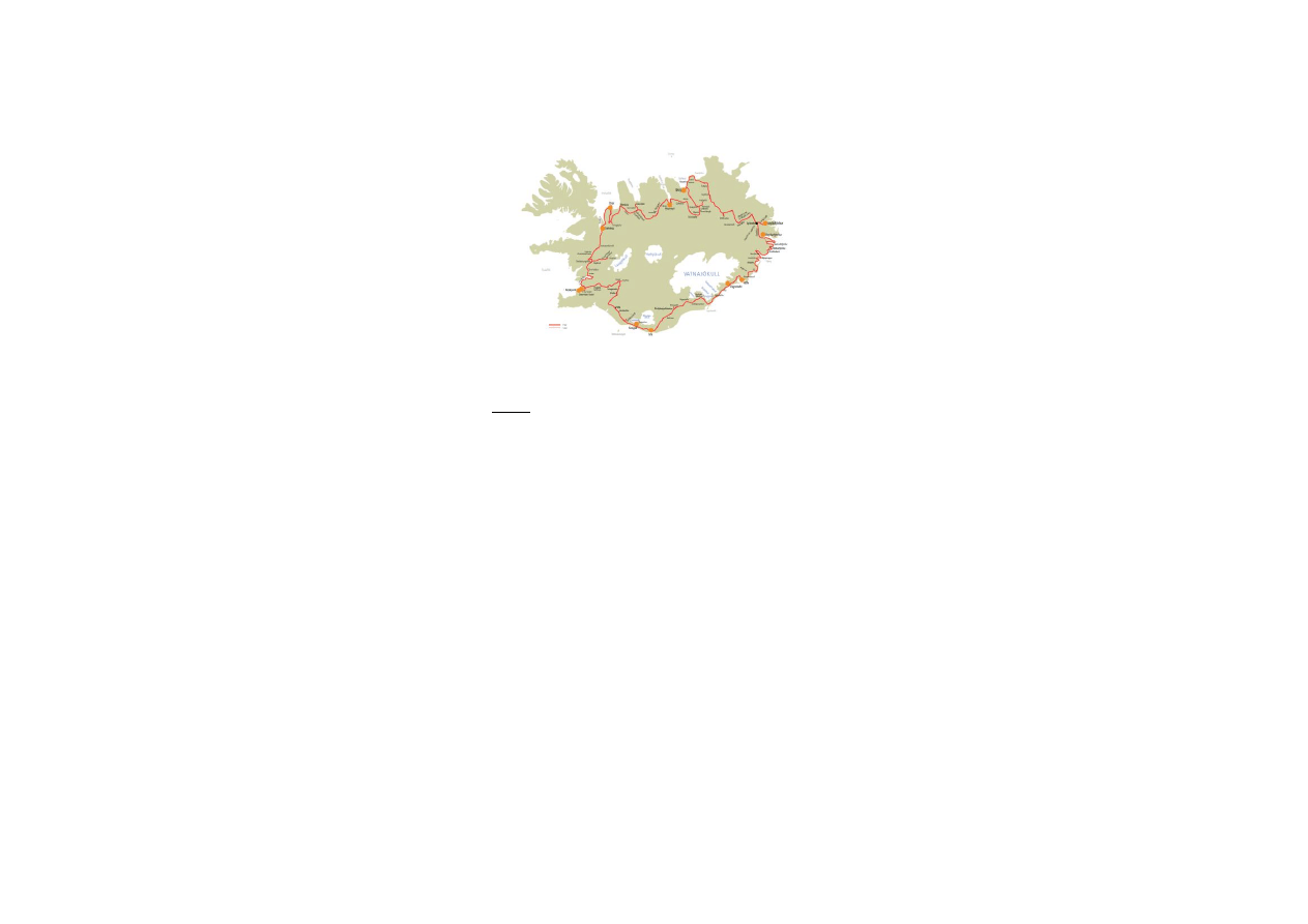
ICELAND on the RING ROAD – 8 days
- starts and ends in Reykjavík
This tour on the ring road is very attractive for those who
want to see the highlights of Iceland in just eight days.
You get a good impression of the various landscapes and
many main attractions of Iceland. The tour starts in
Reykjavík and goes clockwise around the country, but of
course you can do it the other way round. There is also
the possibility to start this tour in East Iceland, if you get
to Iceland by ferry or to start it from any other place along
the ring road no. 1.
Tour disciption
Day 1: Reykjavík → Sæberg/Ósar
Sights: Hvalfjörður, Reykholt, Hraunfossar,
Barnafoss, Deildartunguhver, Grábrók
Day 2:
Sæberg/Ósar → Akureyri
Sights: Kolugljúfur, Blönduós, Víðimýrakirkja,
Glaumbær, Akureyri
Day 3:
Akureyri → Berg
Sights: Goðafoss, Mývatn area
Day 4: Berg → Seyðisfjörður/Reyðarfjörður
Sights: Húsavík, Ásbyrgi, Dettifoss, Möðrudalur,
Lögurinn, Egilsstaðir
Day 5: Seyðisfjörður/Reyðarfjörður → Höfn/Vagnsstaðir
Sights: Stöðvarfjörður, Djúpivogur,
Almannaskarð, Vatnajökull, Höfn
Day 6: Höfn/Vagnsstaðir → Vík/Skógar
Sights: Jökulsárlón, Skaftafell, Skeiðarársandur,
Núpsstaður, Eldhraun, Kirkjubæjarklaustur
Day 7:
Vík/Skógar →Eyrarbakki/Gaulverjaskóli
Sights: Reynisfjara, Dyrhólaey, Skógar
(museum), Skógafoss, Seljalandsfoss,
Eyrarbakki/Stokkseyri
Day 8:
Eyrarbakki/Gaulverjaskóli → Reykjavík
Sights: Kerið, Skálholt, Geysir, Gullfoss,
Þingvellir, Reykjavík
Day 1:
- from Reykjavík drive road no. 1 (ring road) to the north
- pass the small town Mosfellsbær; continue until you
reach the fjord Hvalfjörður
- when you reach Hvalfjörður, turn right onto road no. 47
Hvalfjörður
- the name means Whale Fjord, very picturesque
landscape, very quiet area
- The fjord is about 30 km long and up to 84 km deep.
- There used to be a whaling station in Hvalfjörður, it was
closed in 1992, but now it is in use again for a few days
every year.
- Experienced hikers can hike to the highest waterfall in
Iceland, Glymur 210 m. It is at least a two hours hike,
starting from the bottom of the fjord up through the valley
Botnsdalur. Seek information before starting a hike.
- several view points along the road
- There is an interesting photo exhibition at Ferstikla
service station about a submarine station situated in
Hvalfjörður during World War II and on the former whaling
station.
- just after passing the service station Ferstikla turn right
onto road no. 520
- drive over the mountain pass Ferstikluskarð and through
the valley Svínadalur with its three lakes
- continue on road no. 520, cross the valley Skorradalur
Skorradalur
- 28 km long narrow valley, several farms and
summerhouses
- widespread birch growth, extensive forestation
- lake Skorradalsvatn 16 km long, 60 m deep
- continue on road no. 520; turn right onto road no. 50
- turn right onto road no. 518 to get to Reykholt
Reykholt
- one of Iceland’s most important historical sites
- during the Middle Ages rich farm and a center of religion,
culture and politics
- The famous writer and political leader Snorri Sturluson
(1179-1261), author of the Snorra-Edda or prose Edda
lived there. Today you can see a well-preserved thermal
pool from the Middle Ages, where Snorri used to bathe.
Snorri Sturluson was assassinated in a tunnel, which led
from the bath to his house; you can see the entrance to
this tunnel.
- modern church with a cultural center and a special
library for mediaeval studies, changing exhibitions on
mediaeval Icelandic literature and culture
- traditional church from 19
th
century
- statue of Snorri Sturluson by the Norwegian sculptor
Gustav Vigeland, a gift from Norway, unveiled 1947
- the big white building is a former boarding school, built
during the 1930s by Guðjón Samúelsson
- continue on road no. 518 to Hraunfossar and Barnafoss
waterfalls
Hraunfossar
- waterfalls emerging from the junction of porous rock
and basalt, falling into a 1 km long gorge created by the
glacial river Hvítá
- very picturesque scene in the middle of a huge lava field
(Hallmundarhraun)
- There are also walking paths on the lava field, notice
especially the traditional cairns (vörður) on the walking
paths, interesting vegetation.

- Protected area! Do not leave anything; do not take lava
stones or plants with you!
- The name of this waterfall means the “lava falls”.
- service facilities
Barnafoss
- waterfall just upstream from Hraunfossar, just follow the
walking path.
- Legend has it that two children drowned here when they
tried to cross the river walking on a natural rock arch. The
mother of these children had the arch broken down to
protect other families to meet the same fate. You can see
the remains of that arch at the waterfall.
- The name means the “children’s waterfall”.
- if you are looking for refreshments continue on road no.
518 to go to Húsafell
Húsafell
- woodland and recreation area
- swimming pool, service station, restaurant, shop
- drive back, pass Reykholt, turn right onto road no. 50 (to
the north), not far from the junction you will find
Deildartunguhver
Deildartunguhver
- most powerful natural hot spring in the world, emits 200
liters of boiling water per second
- very impressive scene, seeing the hot water coming out
of the rock
- many greenhouses, some sell delicious Icelandic
tomatoes at the spot
- today the hot water is also used to heat the houses in
Akranes and Borgarnes
- continue in road no. 50, near Varmaland turn right onto
road no. 1
- drive road no. 1 to the north
- not far from Bifröst University College there is the crater
Grábrók (left side of the road)
Grábrókarhraun/Grábrók
- rough lava field, about 3000 years old, covered with
moss and birch growth
- several craters
- Grábrók is one of the craters in Grábrókarhraun, situated
just aside road no. 1
- comfortable walking path up to the top of the crater
- excellent view from the top of Grábrók
- Protected area! Do not leave anything, do not take lave
stones with you!
- continue on road no. 1, drive over highland plateau
Holtavörðuheiði
Holtavörðuheiði
- traditional route between the north and the south of
Iceland
- maximum altitude 400 m
- depending on weather conditions good view towards the
glaciers Eiríksjökull, Langjökull and Hofsjökull
- continue on road no. 1 until you reach the long and
narrow fjord Hrútafjörður
- accommodation is recommended at Sæberg Hostel or
Ósar Hostel
- for further information on Sæberg Hostel, Reykir,
Hrútafjörður,500 Brú – ph.+354-451-0015 / +354-894-
5504
- if you are going to stay at Ósar Hostel, continue on road
no. 1, turn lelft onto road no. 72 (Vatnsnes peninsula),
pass Hvammstangi and continue until you get to Ósar
- for further information on Ósar Hostel, Þverárhreppi, V-
Hún, 531 Hvammstangi – ph.+354-862-2778
(Distances: Reykjavík-Hvalfjörður (Ferstikla) 77 km,
Hvalfjörður (Ferstikla) - Reykholt 45 km, Reykholt-
Húsafell-Deildartunguhver 70 km, Deildartunguhver-
Grábrók 31 km, Grábrók - Hrútafjörður (bottom) 53 km,
Hrútafjörður (bottom) Ósar/Sæberg – 75/15 km; total:
351/291 km)
Day 2:
- from Sæberg continue on road no. 1, leaving the fjord
Hrúafjörður
- from Ósar drive road no. 711 to get back on road no. 1
- drive road no. 1, when you reach the wide green valley
Víðidalur, turn right onto road no. 715 to get to Kolugljúfur
Kolugljúfur
- also known as Kolugil
- gorge in the river Víðidalsá, many waterfalls
- stop at the bridge over Víðidalsá and enjoy the beautiful
landscape
- no services
- drive over the bridge and continue on road no. 718 to
get back to the main road (ring road no. 1)
- drive road no. 1, heading east
Blönduós
- small town, pop. 1000, living on agriculture, transport,
trading
- situated at the mouth of the river Blanda built on both
sides of the river
- very interesting modern church, built in the years 1981-
1985
- all necessary service available, bank, shops, gas station,
restaurant
- nice recreation area on an island in the glacial river
Blanda, worth a stop and a walk (you can see it from the
gas station)
- continue on road no. 1, driving through the valley
Langidalur and over the pass mountain pass Vatnsskarð
Arnarstapi
- coming down the mountain pass Vatnsskarð you should
stop at the memorial for Stephan G. Stephansson and
enjoy the views on the fjord Skagafjörður
- Stephan G. Stephansson (1853-1927) was an Icelandic
farmer and poet who lived in this area before leaving the
country to settle in USA and Canada, he was called the
poet of the Rocky Mountains
- many farmers and poor people from the Skagafjörður
area emigrated to Canada and the USA in the late 19th
and early 20th century, forming the community of the
West-Icelanders in Canada (especially in Manitoba)
- continue on road no. 1

- before getting to Varmahlíð you can find the church of
Víðimýri to the right of road no. 1
Víðimýrikirkja
- traditional turf church from 1834
- one of the most beautiful turf churches still existing in
Iceland
- very good example of traditional Icelandic architecture
- local guide, leaflets, postcards at the spot
- continue on road no. 1, turn left on to road no. 75,
passing the village Varmahlíð to get to Glaumbær
Glaumbær
- very interesting open air and folk museum, former
parsonage and wealthy farm
- one of the few remaining Icelandic turf farms, oldest
parts of it are from the 18th century
- Beside the turf farm, there are buildings from the 19th
and early 20th century, including a church and a former
school for housekeepers.
- Take your time; there are many things to explore and to
learn about everyday life in Iceland.
- There is a very nice café in a cozy old-fashioned tearoom
where you can get traditional Icelandic cakes and other
local snacks.
- for further information on Glaumbær museum contact
ph.+354-453-6173
- drive back on road no. 75, turn right onto road no. 1,
heading east
Öxnadalur
- very deep and narrow valley, 35 km long
- The rocky mountain ridge Hraundrangi is more than
1000 m high and really impressive, many folk tales are
connected to it.
-Two of the most famous Icelandic poets lived in this
valley: Jónas Hallgrímsson (1807-1845), scientist and
poet, was born at the farm Hraun and Jón Þórláksson
(1744-1819), poet and translator, lived at the farm and
parsonage Ytri-Bægisá.
- continue on road no. 1 until you reach the fjord
Eyjafjörður.
Eyjafjörður
- collective name of the fjord and the narrow, well
cultivated valley (60 km long) toward the head of the fjord
- the river Eyjarfarðará runs through the valley into the
fjord
- the town Akureyri is situated in the fjord Eyjafjörður
Akureyri
- so called capital of the North, situated in the narrow fjord
Eyjafjörður
- trading place since 1602, population today 16.000
- interesting sites: botanical garden, modern church by the
architect Guðjón Samúelsson, sculpture “The Outlaw” by
Einar Jónsson, Nonnahús (museum in memory of Jón
Sveinsson, author of children books, for example “Nonni
and Manni”), harbor, folk museum, museum on natural
history
- restaurants, cafés, shops, art galleries etc. in the center
of the town, swimming pool, all year Christmas shop
- tourist information, guided tours by bus, boat and jeep
- airport
- for further information on museums, exhibitions etc.
Contact ph.+354-460-1000
- accommodation recommended at Akureyri Hostel
- for further information on Akureyri Hostel, Stórholt 1
603 Akureyri – ph.+354-462-3657 / +354-894-4299
Day 3:
- drive road no. 1, heading east
Goðafoss
- very impressive waterfall on the river Skjálfandafljót
- Icelandic Sagas tell that back in the year 1000, when the
parliament had decided that Icelanders should adopt the
Christian religion, the law-speaker Þorgeir
Ljósvetningagoði threw his pagan idols into the river. After
that the waterfall was named the “waterfall of the idols” or
gods.
- walking paths, lovely moss and birch growth, please be
careful not destroying it
- cafeteria, shop and service
- continue on road no. 1 to reach the Mývatn area
Mývatn
- beautiful shallow lake in a region of volcanic activity and
geothermal heat
- during the summer a paradise for ducks and other birds,
average number of 50000 pairs of ducks of 15 species
- very good trout fishing
- extremely beautiful surrounding area, covered with lava
and growth
- interesting geological phenomena like pseudo craters,
lava caves, hot mud and steam springs, canyons etc.
- the name means “lake of the midges”, during the
summer swarms of midges can make life unpleasant here,
but these midges do not bite
- several service stations and restaurants around the lake
- here are several suggestions for spending the day:
Reykjahlíð
- church and former parsonage, today a small village of
200 inhabitants
- service, restaurant, bank, supermarket, shop
- In the year 1829, the church was threatened by a
volcanic eruption but miraculously the flow of lava stopped
just a few meters from the church. A modern church was
built on the same site in 1972.
Jarðböðin
- very interesting: “Jarðböðin”
- The Mývatn Nature Baths, opened in 2004, are an
outstanding attraction, offering excellent bathing facilities
in an outdoor lagoon whose temperature is 38-40
o
C
- service and information center, cafeteria
- for further information contact ph. +
354-464-4411
Námafjall
- mountain south of the pass Námaskarð, former sulfur
mine, the east side of the mountain is all covered by signs
of geothermal heat
- impressive bubbling mud pools, steam vents, hot boiling
springs and fumaroles, distinctive stench of sulfur
everywhere
- there are roped-off paths, please do stick to those paths,
it is extremely dangerous to walk around in this area, the
surface material is fragile and the ground is extremely
hot

Krafla and Víti
- cone-shaped volcano north of Námafjall, but also a
system of fissures
- considerable geothermal heat on the west side of Krafla
- Geothermal Power Station, build in 1984, later extended
- The crater Víti is situated nearby Krafla, its name means
“hell” in Icelandic
Skútustaðir
- famous for a number of pseudo craters, formed by gas
explosions when hot lava flew into the waters, looking like
circular craters or small islands
- protected area, please do not leave the walking paths
and close the gates behind you
- service, shop, cafe
Dimmuborgir
- quite unique recreation area
- valley filled up with bizarre lava formations, caves, holes
and pillars.
- protected area, very sensible birch growth
- several marked walking paths, don not leave the roped
off routes, you can easily get lost in this labyrinth of dark
lava rocks
- newly built service and information centre at the
entrance, cafeteria
- accommodation recommended at Berg Hostel
- from lake Mývatn drive road no. 87 to the north, when
you reach road no. 85 turn left and after a short while
right onto road no. 852 to find Berg
- for further information on Berg Hostel, Sandi,
Aðaldal, 641 Húsavík – ph.+354-464-3777
(Distances: Akureyri – Goðafoss 50 km, Goðafoss –
Mývatn (Reykjahlíð) 53 km, Mývatn (Reykjahlíð) – Berg
Hostel 47 km; total depends on what sights you choose at
Mývatn)
Day 4:
- from Berg Hostel drive road no. 852 and turn left onto
road no. 85, drive north to get to Húsavík
Húsavík
- nice small town, situated in the bay of Skjálfandafljót,
population 2500
- former fisher town with excellent natural harbor
conditions
- populating now mostly living on service and tourism
- schools, hospital, centre of higher education, banks etc.
- In Húsavík the first Icelandic whale watching tours
started in the early 90’s
- really interesting professional museum and exhibition on
whales and former whaling in Iceland (all the way back to
the Middle Ages), contact ph.+ 354 414 2800
- Whale watching recommended! There are different
companies offering whale watching in Húsavík. A trip takes
at least 3 hours.
- church, restaurants, cafés, shops, swimming pool, all
services near by the harbor
- hiking trails along the shore, up to Húsavík mountain
(where you will find a surprising hot water bath), around
the small lake Botnsvatn
- hot springs and geothermal heat
- drive road no. 85 on Tjörnes peninsula
- drive over the bridge at Lón and continue to get to
Ásbyrgi
Ásbyrgi
- U-shaped valley, surrounded by dark cliffs up to 90 m
high
- Legend has it that this is the footprint of the horse
Sleipnir. It had eight legs and was the horse of the Norse
god Odin.
- Geologists think that Ásbyrgi was shaped by enormous
glacier floods coming underneath the glacier Vatnajökull.
- protected area, long and short walking and hiking trails,
information on nature history of the area provided in
brochures and on information tablets
- small romantic lake “Botnstjörn”, home to the lovely
green-winged teal (duck)
- service, shop, cafeteria just outside the area, near by the
road
- coming from Ásbyrgi continue on road no. 85, cross the
bridge over the river Jökulsá á Fjöllum, just after the
bridge turn right
- drive road no. 864 to get to Dettifoss
- Please have in mind that not all vehicles are suitable for
driving on highland roads!
- Road no. 864 is closed during the winter season and
early summer if conditions are very bad.
- Please always get information on road and weather
conditions before driving highland roads contact ph.+354-
522-1000
Dettifoss
- one of the most impressive waterfalls in Iceland and
claimed to be the most powerful waterfall in Europe
- although just 45 m high it dispatches 500 m3 water per
second, since this water comes from a glacier it is of dark
color
- walk from parking to the waterfall takes at least 20
minutes, please be careful, and do not step out of the
marked trails
- continue on road no. 864 (heading south) until you reach
road no. 1
- turn left onto road no. 1, drive to the east over the
desert-like plateau Möðrudalsöræfi
Möðrudalur
- farm, situated at higher altitude than any other Icelandic
farm
- just a few kilometers from road no. 1 (road no. 901)
- former parsonage, present church built by the farmer Jón
Stefánsson, who also painted the altar-piece
- very nice café, called the mountain café (Fjallakaffi), only
during summer season
- impressive views on the mountain ridge
Möðrudalsfjallgarður and the majestic Herðubreið (1.682
m high), one of the most beautiful Icelandic mountains
- the local painter Stórval painted this mountain over and
over again
- turn back on road no. 1, drive east
Jökuldalur
- narrow, long valley with low mountains on both sides

- formed by the glacier river Jökulsá á Dal
- just a few farms, good grassland
- nice waterfalls along the road, if you stop please be
careful not to disturb the traffi
Jökulsá á Dal or Jökulsá á Brú
- once one of the biggest glacial rivers in Iceland, now
very much changed because of the Kárahnjúkar power
plant
- as all glacial rivers it carried a lot of sand, clay and
stones, 112 tons of this material flooded into the bay of
Héraðsflói every day, now it often is an almost clear fresh
water river
- 1994 a modern bridge was finished, “Jökulsábrú”, 119 m
long, there is a view point at the eastern edge of the
bridge with a good view into the gorge, 70 m wide and 40
m deep
- continue on road no. 1 until you reach Lögurinn
Lögurinn or Lagarfljót
- lake, 2 km wide and 24 km long, 53 m², only 20 m
above sea level but very deep with 111 m
- contains brown or grey glacial water
- a monster is believed to live in the lake, called
Lagarfljótsormurinn (the drake of Lagarfljót), the
descriptions are very similar to those of the monster of
Loch Ness
- largest woodlands of Iceland on the eastern banks of
Lagarfljót
- cross the bridge over Lögurinn to get to Egilsstaðir
Egilsstaðir
- the town Egilsstaðir is the administrative centre of the
East Fjords
- modern small town, 1700 inhabitants
- schools of higher education, hospital etc.
- all necessary service, supermarket, fuel station,
swimming pool, folk museum, library etc.
- accommodation is recommended at Seyðisfjörður
Hostel or Reyðarfjörður Hostel
- if you are going to stay at Seyðisfjörður Hostel, drive
road no. 93 over the highland moor Fjarðarheiði
Fjarðarheiði
- highland moor (620 m) that divides the fjord
Seyðisfjörður from the town Egilsstaðir
- the road is steep at both ends and driving conditions can
be very difficult, weather is often rough or foggy up here
- if there is no fog, you have very nice views over the fjord
and the inland district Fljótsdalshérað
Seyðisfjörður
- town at the head of a narrow curving fjord of the same
name, population about 800
- The town developed rapidly during the late 19
th
and early
20
th
century.
- Trading and fishing started in the 19th century when the
Norwegian Otto Wathne opened a herring fishing and
processing station, later the Icelandic population learned
from the Norwegians how to exploit the herring.
- good harbor, the ferry Norröna from Denmark and
Norway lands in Seyðisfjörður.
- attractive harbor side with traditional Norwegian-
Icelandic timber houses
- Seyðisfjörður was a US naval base during World War II
- hiking trails
- accommodation recommended at “Hafalda”
Seyðisfjörður Hostel
- for further information on Seyðisfjörður Hostel
see website
- if you are going to stay at Reyðarfjörður Hostel, drive
road no. 92
Reyðarfjörður
- town in the fjord Reyðarfjörður
- expanded very much during the last years because of the
new built aluminum smelter a few km away from the town
- Reyðarfjörður was built up as a naval US base during
World War II; see the Icelandic Wartime Museum
(Stríðsárasafnið)
- from here you could also visit the towns Eskifjörður and
Neskaupstaður, driving there is a unique experience
because of the high mountain passes (630 m) with
astonishing views over the fjords and the ocean
- accommodation recommended at Reyðarfjörður Hostel
- for further information on Reyðarfjörður Hostel,
Vallargerð 9 and 14, 730 Reyðarfjörður –ph. +354-892-
0336
(Distances: Berg-Húsavík 21 km, Húsavík-Ásbyrgi 64 km,
Ásbyrgi-Dettifoss 30 km, Dettifoss-Möðrudalur 65 km,
Möðrudalur-Egilsstaðir 109 km, Egilsstaðir-Seyðisfjörður
27 km, Egilsstaðir-Reyðarfjörður 29 km; total: 316/318
km)
Day 5:
- from Seyðisfjörður drive back to Egilsstaðir and from
there to Reyðarfjörður, road no. 92
- when you get to Reyðarfjörður fjord turn right (not into
town)
- if you are coming from Reyðarfjörður town, drive back to
the junction at the bottom of the fjord
- you can choose if you want to drive through the new
tunnel to Fáskrúðsfjörður or around the fjord (road no. 96)
Fáskrúðsfjörður
- narrow fjord and fisher village
- there was much French influence here in earlier centuries
because French fishermen had their consulate, hospital
and cemetery in Fáskrúðsfjörður
- one weekend every summer people celebrate the French
Festival (Franskir dagar)
- there is also an exhibition on the French influence in
Iceland
- when you come out of the tunnel you will find a small
parking lot in a very nice surrounding, inviting for a short
walk
- continue on road no. 96
Stöðvarfjörður
- small fjord, former fisher village with fish processing,
today rather a quiet small village
- famous for the “stone collection” of Petra Steinsdóttir
(Steinasafn)
- Steinasafn is an impressive private collection of stones.
Petra decided early in her youth to collect rocks from the

East Fjords, now these rocks have taken over the home
and very lovely garden owned by Petra – worth a visit,
have a chat with family members and enjoy the rocks and
things in house and garden
- continue on road no. 1, passing the bay Breiðdalsvík
Berufjörður
- very picturesque narrow but long fjord, no harbor or
fisher village but several farms
- many possibilities to stop and explore the surroundings
by foot
Djúpivogur
- beautiful little village centered around the harbor, the
most southern of the East Fjords
- boat trips to the island Papey
- nice walks and bird watching possibilities, also an
exhibition on bird life in Iceland
- museum Langabúð, wooden warehouse building from the
18
th
century, nice café
- swimming pool, supermarket, bank etc.
- continue on road no. 1, drive through the fjords
Hamarsjförður and Álftafjörður
- now you are getting into a very different landscape,
leaving the East Fjords behind
- the glacier Vatnajökull dominates the southeastern parts
of Iceland
- in the glacial river valley Lón you will cross the first
glacial river (Jökulsá í Lóni) and possibly you can get a
glimpse on one of the glaciers up in the mountains
- Just before you drive through the tunnel, you can turn
right and drive up to the mountain pass Almannakarð.
With a little luck, you can experience astonishing views on
the icy vastness of Vatnajökull. Maybe you can see the
highest point of Iceland, Hvannadalshnúkur (2.110 m) in
the southern part of Vatnajökull. On a flat peninsula right
below your point of view, you can see the small town
Höfn. Panorama maps explain the views.
- drive back and through the tunnel, continue on road no.
1
- there are many viewpoints along the road where you can
stop and take pictures, be careful not to disturb the traffic
Vatnajökull
- largest glacier in Iceland, 8.200 km², up to 900 m thick
- underneath the glacier is one of the most powerful
geothermal areas of the world and many active volcanoes
- the highest point of Iceland is Hvannadalshnúkur (2110
m) in the southern parts of Vatnajökull is called
Öræfajökull
- many glacier tongues jut out of Vatnajökull, all have
their own names and different shapes
Höfn
- small town at the south coast of Iceland
- you need to leave road no. 1 to get to Höfn, road no. 99,
just 4 km
- 1800 inhabitants, living on fishing, tourism, service
- all necessary service available including library, new
swimming pool, restaurants, shopping centre, tourist
information etc.
- very interesting glacier exhibition, really worth a visit
- nice walk on Nes, an area near the harbor, great view on
the Vatnajökull, memorial for fishermen, bird colonies,
especially the arctic tern
- one weekend during the summer season, people
celebrate the Lobster Festival
- accommodation is recommended at Höfn Hostel or
Vagnsstaðir Hostel
- for further information on Vagnsstaðir Hostel, Suðursveit
A-Skaftafellssýsla, 781 Höfn – ph.+354-4781048
(Vagnsstaðir is situated 50 km from Höfn)
- for further information on Höfn Hostel, Hafnarbraut 8,
780 Höfn –ph. +354-4781736
(Distances: Seyðisfjörður-Egilsstaðir-Reyðarfjörður (fjord)
58 km, Reyðarfjörður-Fáskrúðsfjörður (tunnel)-
Stöðvarfjörður 34 km, Stöðvarfjörður-Djúpivogur 82 km,
Djúpivogur-Höfn 102 km, Höfn-Vagnsstaðir 50 km)
Day 6:
- from Höfn or Vagnsstaðir drive road no. 1 to the west
Breiðamerkurjökull and Jökulsárlón
- broad glacier tongue that once reached the ocean but
started to retreat during the early 20
th
century
- today between glacier and coast line there is a deep
glacial lagoon: Jökulsárlón
- here we have the lowest point of Iceland
- often many icebergs float on the water before melting
down
- it is a must to stop at Jökulsárlón, take a walk, make
photos and last but not least book a guided boat trip on
the lagoon – a real highlight of your Iceland vacation,
take your time!
- colony of the Arctic tern, seals, other birds
- guided tours, cafeteria, souvenir shop etc. at Jökulsárlón,
contact ph.+354-478-2122
- continue on road no. 1, just before getting on
Skeiðarársandur turn right to reach the service centre of
Skaftafell National Park
Skaftafell National Park
- boundered by glaciers the Skaftafell National Park covers
1.700 km²
- it is an excellent area for hiking, there are several hiking
trails for long and short hikes, difficult and easy
- most famous is the hike to Svartifoss (the Black
Waterfall), a lovely waterfall surrounded by picturesque
basalt columns (1,5 hour), during the hike you also get a
great view over Skeiðarársandur and over to
Hvannadalshnúkur
- you can also walk to the glacier Skaftfellsjökull, get
information at the visitor centre
- interesting exhibitions, video on the volcanic eruption
and glacier flood in 1996
- cafeteria, souvenir shop, guided mountain and glacier
tours etc.
- drive back onto road no. 1, cross the black desert of
Skeiðarársandur
Skeiðarársandur
- largest black sand desert, formed by glacial rivers and
catastrophic glacial floods coming out from Skeiðarárjökull
glacier
- longest bridge in Iceland, 904 m (but in summer 2009
the river disappeared)

- in 1996 this bridge like several others was destroyed
after volcanic eruptions underneath the glacier, followed
by glacial floods, see the memorial before crossing the
Skeiðarár-bridge
- ever changing breathtaking landscape of glaciers,
mountains, rivers, black sand and the ocean
- all the glacier tongues you are going to drive along for
the rest of the day are part of the biggest glacier in
Iceland and Europe, Vatnajökull
- you will see ahead the impressing inland cliff
Lómagnúpur (approx. 700 m high)
- just after passing Lómagnúpur you should stop at
Núpsstaður
Núpsstaður
- farm from early 20
th
century, still inhabited (please be
polite not causing inconvenience)
- buildings (sheds, houses, stables) from different periods,
some of them turf buildings with grass roofs
- very nice and interesting small chapel, owned by the
National museum of Iceland, open to visitors
- enlisted on UNESCO, World Heritage:
- continue on road no. 1, just before reaching the town
Kirkjubæjarklaustur, you could visit the so called church
floor
Kirkjugólf
- “church floor”
- formation of basalt columns that looks like the floor of a
mediaeval church
- nice little walk
- return to road no. 1
Kirkjubæjarklaustur
- small village in a beautiful landscape
- Christian settlement all from the beginning of Icelandic
history
- from 12
th
to 16
th
century there was a convent, many
place names remind on it (for example sisters fall, sisters
lake etc.)
- church reminds on the rev. Jón Steingrímsson who is
believed to have stopped the lava flow of 1783 by his fire
sermon (eldmessa)
- all necessary service available, bank, post office,
supermarket, tourist information, fuel station, restaurants,
swimming pool
Eldhraun
- “fire lava”, lava flow from a row of craters called
Lakagígar, 75 km northwest from here
- this flow is the largest in the world, 565 km², caused by
eruptions in 1783-84
- these eruptions meant one of the most dangerous
catastrophes of nature to the Icelandic people, it caused a
famine, 20% of the entire population died
- the lava is now covered by a thick layer of moss, when
you stop to watch around, please be careful not to damage
the moss by stepping on it or removing it
Vík
- small village in the picturesque landscape near the valley
Mýrdalur, 300 inhabitants
- southernmost village in Iceland
- restaurant, cafeteria, service station, wool factory,
handcrafts
- great view of the impressive cliffs “Reynisdrangar” (66 m
high, folktales say they are trolls that turned to stone at
first daylight)
- walking path on the mountain Reynisfjall, good
opportunity for bird watching
- accommodation is recommended at Vík Hostel or
Skógar Hostel
- for further information on Vík Hostel, Suðurvíkurvegur 5
870 Vík – ph. +354-487-1106 / +354-867-2389
- if you are going to stay at Skógar Hostel, continue on
road no. 1
- for further information on Skógar Hostel, Skógar
861 Hvolsvöllur – ph. +354-487-8801 or +354-899-5955
(Distances: Höfn/Vagnsstaðir-Jökulsárlón 75/28 km,
Jökulsárlón-Skaftafell 57 km, Skaftafell-
Kirkjubæjarklaustur 67 km, Kirkjubæjarklaustur-Vík 71
km, Vík-Skógar 32 km)
Day 7:
- from Vík continue on road no. 1
- if you stayed at Skógar you need to drive back on road
no. 1 (or you could visit Reynisfjara and/or Dyrhólaey the
day before)
- just after passing the mountain pass over Reynisfjall,
turn left onto road no. 215 to get to Reynisfjara
Reynisfjara
- very impressive black sand and pebbles beach at the foot
of the mountain Reynisfjall
- cliffs and caves with interesting basalt column formations
- nesting site of puffins and other seabirds
- great view of Dyrhólaey
- it is a very beautiful place, but please be careful, the
ocean is extremely dangerous here and rock falls have
occurred
- facilities
- return to road no. 1, continue driving to the west
- to visit the bird cliff Dyrhólaey turn left onto road no.
218
Dyrhólaey
- small peninsula with 120 high cliff and offshore stacks
with a good selection of breeding sea birds, including
puffins, gulls and fulmars
- cliffs rising over a long expanse of black sand
- all the cliffs, rocks etc. are a protected area, be careful
not to disturb the birds or damage the vegetation, during
early summer Dyrhólaey can be closed for protecting the
colony of eider ducks
- lighthouse build by a famous Icelandic architect (Guðjón
Samúelsson)
- no facilities
- get back on road no. 1, continue driving to the west
Skógar
- the name refers to two farms, a school and an open-air
museum, near the waterfall Skógafoss
- very interesting folk museum: a church replica, various
types of traditional stone and turf farm buildings and two
modern building for exhibitions
- countless artifacts of former everyday life in a farming
and fishing society, collected over more than 5 decades

- exhibition on history of transportation and infrastructure
in Iceland
- guided tours available, nice café, worth a prolonged stay
Skógafoss
- one of the most beautiful waterfalls in Iceland, 60 m
high, walking path beside the waterfall to climb up the
mountain
- facilities
- get back on road no. 1, drive west, turn right onto road
no. 249 to find the waterfall Seljalandsfoss
Seljalandsfoss
- very beautiful waterfall in the river Seljalandsá, 40 m
high, narrow but powerful waterfall
- sensational walk on a foot path behind the waterfall
- bird colonies, fulmars
- facilities
- get back on road no. 1, continue driving west, passing
Hvolsvöllur and Hella, crossing Þjórsá
Selfoss
- modern town on the banks of the river Ölfusá, about
4.300 inhabitants
- mostly living on service and trade, but there is also the
biggest dairy industry here
- the bridge over Ölfusá is the most important connection
between the Reykjavík area and the south of Iceland, the
first bridge there was built in 1891, after that the town
started to develop
- all necessary service available, including swimming pool,
shops, cafes, supermarket, fuel station etc.
- from Selfoss turn onto road no. 34 to get to Eyrarbakki
and Stokkseyri
- before getting to Eyrarbakki you could also turn right and
visit the impressive estuary mouth of the biggest river in
Iceland, Ölfusá
Ölfusá
- biggest river in Iceland, glacial river with grey “muddy”
water
- impressive estuary into the ocean in the southwest of
Iceland
- stop near the bridge Óseyribrú
Kerið
- crater about 55 m deep, formed approximately 3000
years ago
- 7-14 m deep lake in the bottom with a strange green
color
- walking path around the crater, private property, please
be careful not to damage the vegetation, do not take lava
stones with you
- continue on road no. 35
- turn right onto road no. 31 to get to Skálholt
Skálholt
- former most important religious and educational center,
bishopric founded 1056
- 1784 it was destroyed by an earthquake and the
bishopric was moved to Reykjavík
- Many historical events are connected to Skálholt, in 1550
the last catholic bishop of Iceland, Jón Arason, was
beheaded here, today there is a memorial stone in
memory of bishop Arason.
- interesting modern memorial church, built in the 1950’s
with a remarkable tapestry-like mosaic by artist Nína
Tryggvadóttir and fascinating stained-glass windows by
artist Gerður Helgadóttir
- ongoing archeological excavations
- cafeteria in the nearby school
- really worth a visit
- drive back on road no. 31, turn right onto road no. 35
- continue on road no. 35, pass Reykholt
Geysir
- hot spring area in the valley Haukadalur, named after
the famous hot spring Geysir
- eruptions of Geysir itself are unpredictable, but the hot
spring Strokkur erupts every 5 to 10 minutes
- restaurant, cafeteria and gas service station, souvenir
shop etc.
- interesting multi-media exhibition on the geology of this
area called Geysisstofa
- continue on road no. 35 to reach Gullfoss
Gullfoss
- famous and very impressive waterfall in the river Hvítá,
the name means Golden Waterfall
- The water falls into a gorge, which is 70 m deep. The
waterfall itself is 32 m high and 250 m wide, falling in two
cascades.
- exhibition on the nature reserve of river Hvítá situated
in an information center called Sigríðarstofa
- cafeteria, souvenir shop etc. just beside Sigríðarstofa
- parking recommended “upstairs” on the parking lot at
the service center
- drive back on road no. 35 passing Geysir
- continue on road no. 37 to get to Laugarvatn
Laugarvatn
- lake with geothermal heat on the banks and the bottom
- When the Icelanders in the year 1000 voted to become
Christians many of them were baptized in the warm spring
at the bank of Laugarvatn (Vígðalaug).
- village with a number of schools, a College of Physical
Education, sport grounds, a natural steam bath and
greenhouses
- after passing Laugarvatn, turn onto road no. 365 (gravel
road, often in bad condition, be careful)
- when you reach lake Þingvellir, turn right onto road no.
36
Þingvellir National Park
- most important place in Icelandic history
- national park since 1928
- situated on the banks of lake Þingvallavatn, the largest
lake in Iceland (84 km²)
- The historical Icelandic parliament (Alþingi) was founded
here in the year 930. It was the biggest annual event for
Icelandic farmers. They came together for two weeks
every summer to meet each other and to follow the
parliament sessions. At this site Icelanders voted to
become Christians in the year 1000.
- Þingvellir is a large lava field, situated right on the Mid-
Atlantic Ridge, where the European and North American
plates are moving apart.
- service station and tourist information during summer
- excellent multimedia-exhibition on geology, wild life and
history near the view point above the gorge Almannagjá

- many hiking trails, information spots
- leave Þingvellir on road no. 36 to get to Reykjavík,
passing the small town Mosfellsbær
- accommodation is recommended at Reykjavík City Hostel
or Reykjavík Hostel Downtown
- for further information on Reykjavík City Hostel,
Sundlaugavegur 34, 105 Reykjavík – ph.+354-553-8110
- for further information on Reykjavík Hostel
Downtown, Vesturgata 17, 101 Reykjavík – ph.+ 354
553 8120
(Distances: Vík- Dyrhólaey-Skógar 42 km, Skógar-
Seljalandsfoss 30 km, Seljalandsfoss-Selfoss 70 km,
Selfoss - Kerið 10 km, Kerið-Skálholt 23 km, Skálholt-
Geysir-Gullfoss 41 km, Gullfoss-Laugarvatn-Þingvellir
(service station) 62 km, Þingvellir-Reykjavík 45 km; total:
324 km)
Wyszukiwarka
Podobne podstrony:
090219 3404 NUI FR 160 $3 9 million spent on the road to success in?ghanistan
on the road analyse RJVDSG2WQHCLFAPZX7ACRFFGKS7U6IR26AW2BLA
On the road again Text
Kerouac On The Road
on the road TSOFF7NLA34N3UKMLKQPKT2HZVNWJIDVN6HAYXA
Donaldson John A Legend on the Road Bobby Fischer Simultans, 2005 OCR Russell, 18p
w drodze on the road fce wszystkie z 2013 10 06 u 406698
Lackey, Mercedes Elves on the Road 02 Diana Tregarde 02 Children of the Night
West Iceland incl snaefellsnes and the west fjords 7 days
Lackey, Mercedes Elves on the Road 01 Bedlam Bard 02 Bedlam Boyz (Ellen Guon )
Parzuchowski, Purek ON THE DYNAMIC
Enochian Sermon on the Sacraments
GoTell it on the mountain
Interruption of the blood supply of femoral head an experimental study on the pathogenesis of Legg C
CAN on the AVR
Ogden T A new reading on the origins of object relations (2002)
J R R TOLKIEN 1 The Fellowship of the Ring
On the Actuarial Gaze From Abu Grahib to 9 11
91 1301 1315 Stahl Eisen Werkstoffblatt (SEW) 220 Supplementary Information on the Most
więcej podobnych podstron