
213
Abstract
The ever-increasing need to integrate knowledge from the diverse dis-
ciplines of the Earth System sciences requires to switch from data-centric systems
towards service-oriented enabling infrastructures. Important international initiatives
and programmes are defining a standard baseline for interoperability of geospatial
information, models and technologies, in particular for data discovery and access.
We describe the design of an e-infrastructure for Earth Sciences, from the point of
view of the data, services and distribution model. This design is implemented in the
Siberian Earth System Science Cluster (SIB-ESS-C), an e-infrastructure supporting
the generation and distribution of products and information about central Siberia,
along with advanced analysis tools for Earth Sciences.
Keywords
Interoperability • Geospatial information • Spatial data infrastruc-
ture • Siberia • Earth Observation
13.1 Introduction
Scientific and technological advancements in sensors, remote sensing and aerospace
industry are set to increase exponentially the availability of geospatial information,
in the near future. It is estimated that there are currently around 100,000 in-situ
stations and 50 environmental satellites.
1
Likewise, the advancements of research
S. Nativi (*) and L. Bigagli
Italian National Research Council – IMAA and University of Florence, Prato, Italy
e-mail: nativi@imaa.cnr.it; lorenzo.bigagli@pin.unifi.it
C. Schmullius and R. Gerlach
Friedrich-Schiller-University, Jena, Italy
e-mail: c.schmullius@uni-jena.de; roman.gerlach@uni-jena.de
Chapter 13
Interoperability, Data Discovery
and Access: The e-Infrastructures
for Earth Sciences Resources
S. Nativi, C. Schmullius, L. Bigagli, and R. Gerlach
H. Balzter (ed.), Environmental Change in Siberia: Earth Observation,
Field Studies and Modelling
, Advances in Global Change Research 40,
DOI 10.1007/978-90-481-8641-9_13, © Springer Science+Business Media B.V. 2010
1
http://ec.europa.eu/research/environment/themes/article_1357_en.htm

214
S. Nativi et al.
in environmental sciences, supported by the increasing capacity of computational
platforms and telecommunication infrastructures, will allow to deepen our under-
standing of natural phenomena. Therefore, there is an ever-increasing need to inte-
grate knowledge from the diverse disciplines engaged in studying the constituent
parts of the complex Earth system.
Earth system analysis is a real challenge for scientists as much as it is for information
technology. In fact, the scope and complexity of Earth system investigations
demand for the formation of distributed, multidisciplinary collaborative teams. This
requires the integration of different discipline information systems, characterized by:
heterogeneous and distributed data and metadata models, different semantics and
knowledge, diverse protocols and interfaces, different data policies and security levels
(Foster and Kesselman
). Advanced e-infrastructures (aka cyber-infrastructures)
will support the formation and operation of a Earth System Science Community,
based on multidisciplinary knowledge integration. Developing an advanced
enabling infrastructure to facilitate the Earth system analysis implies to scale from
specific and monolithic systems (data-centric) towards independent and modular
(service-oriented) information systems (Foster and Kesselman
Advanced e-infrastructures will provide scientists, researchers and decision
makers with a persistent set of independent services and information that scientists
can integrate into a range of more complex analyses. The importance of the geo-
spatial information to support the decision process and the management of environ-
mental issues at the different scales (i.e. national, international and global) was
already recognized and outlined by the United Nations Conference on Environment
and Development (Rio de Janeiro, June 1992) and by the General Assembly for the
implementation of Agenda 21 (New York, June 1997).
In these years, there were launched important initiatives and programmes by
the European and International Communities to design and build such advanced
e-infrastructures in order to collect, manage and share geospatial information pro-
viding the Society with Earth and environmental information in a handy and near
real-time way. These initiatives are resulting decisive to reach out to the different
Earth Sciences disciplines and systems. The most relevant to our topic are briefly
presented below.
13.1.1 GEOSS
In 2005, member countries of the Group on Earth Observations (GEO) agreed on
a 10-year implementation plan for a Global Earth Observation System of Systems
(GEOSS).
2
In 2006, GEO has begun implementation of the GEOSS 10-Year
Implementation Plan as endorsed by the Third Earth Observation Summit. GEOSS
2
http://earthobservations.org/geoss.shtml

215
13 Interoperability, Data Discovery and Access
is a worldwide effort to build upon existing national, regional, and international
systems to provide comprehensive, coordinated Earth observations from thousands
of instruments worldwide, transforming the data they collect into vital information
for society. GEOSS will meet the need for timely, quality long-term global informa-
tion as a basis for sound decision making, and will enhance delivery of benefits to
society in nine Societal Benefit Areas (SBAs), identified as key applications of
GEOSS, namely: Disasters, Health, Energy, Climate, Water, Weather, Ecosystems,
Agriculture, Biodiversity. GEOSS Architecture and interoperability process are
investigated by a couple of pilot initiatives: the Architecture Implementation Pilot
(AIP) (Percival
) and the Interoperability Process Pilot Project (IP3) (Khalsa
et al.
).
13.1.2 GMES
The European Global Monitoring for Environment and Security (GMES)
3
initiative
is a concerted effort promoted by the European Community and the European
Space Agency to bring data and information providers together with users, so they
can better understand each other. GMES will support the implementation of public
policies at European or national level that deal with, for example, agriculture, envi-
ronment, fisheries, or regional development, external relations, security. GMES is
set to be the main European contribution to GEOSS. The main GMES objective is
to make environmental and security-related information available to the people who
need it through enhanced or new services. The services identified by GMES can be
classified in three major categories:
• Mapping, including topography or road maps but also land-use and harvest,
forestry monitoring, mineral and water resources that do contribute to short and
long-term management of territories and natural resources. This service gener-
ally requires exhaustive coverage of the Earth surface, archiving and periodic
updating of data.
• Support for emergency management in case of natural hazards and particularly
civil protection institutions responsible for the security of people and property.
• Forecasting is applied for marine zones, air quality or crop yields. This service
systematically provides data on extended areas permitting the prediction of
short, medium or long-term events, including their modeling and evolution.
The widespread and regular availability of technical data within GMES will allow
a more efficient use of the infrastructures and human resources. It will help the
creation of new models for security and risk management, as well as better manage-
ment of land and resources.
3
http://www.gmes.info

216
S. Nativi et al.
13.1.3 INSPIRE
The Directive 2007/2/EC of the European Parliament and of the Council of 14
March 2007 establishing an Infrastructure for Spatial Information in the European
Community (INSPIRE),
4
as published in the official Journal on the 25 April 2007,
establishes a regional Spatial Data Infrastructure (SDI) in Europe, also addressing
some aspects of environmental monitoring. INSPIRE is conceived to serve policy-
makers, planners and managers at European, national and local level and the citi-
zens and their organizations, delivering to the users integrated spatial information
services was. The INSPIRE Directive entered into force on the 15 May 2007. Five
Drafting Teams have been designing the directive implementation rules, as far as its
architecture, data policy and monitoring process are concerned. The first approved
regulation concerns metadata.
In the following sections, we elaborate on remote sensing in Siberia and we intro-
duce the current standard baseline for interoperability of geospatial information, pre-
senting the main adopted models and technologies, in particular for data discovery and
access. We introduce the Siberian Earth System Science Cluster (SIB-ESS-C), a large
database of datasets and value-added products spanning the central Siberian region.
SIB-ESS-C realizes a initial SDI (i.e. an e-infrastructure) to generate and distribute
products and information about central Siberia, along with advanced analysis support
for Earth Sciences. This is a valuable example of how scientific data can be published
and accessed under the interoperability paradigm. We present some results concerning
the implementation of advanced access, discovery and processing services for SIB-
ESS-C. The infrastructure architecture applies relevant international standards and best-
practices; its interoperability with the introduced relevant initiatives is argued.
13.2 The Siberian Earth System Science Cluster
The main goal of the Siberian Earth System Science Cluster
5
is to provide an infra-
structure for spatial data to facilitate Earth system science studies in Siberia. The
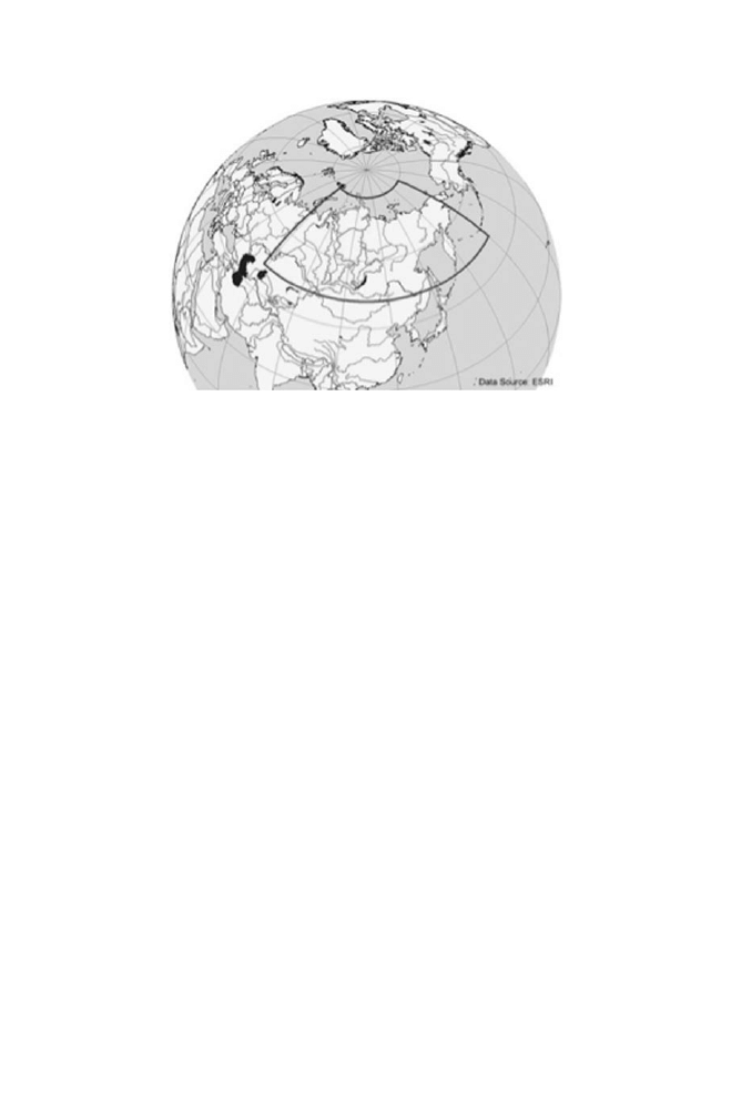
region under study covers the entire Asian part of the Russian Federation from 58°
E–170° W and 48–80° N. The region comprises a significant part of the Earth’s
boreal biome, but also includes a large portion of the arctic biome and a small por-
tion of the temperate biome in Northern Eurasia. The watersheds of the rivers Ob,
Yenissei and Lena representing the main freshwater source of the Arctic Ocean are
located in this region. Figure
depicts the interested geographic area. With
respect to Global Climate Change several studies identified Siberia as one of the
hotspots where temperature changes are more pronounced than in other regions of
the world (Hansen et al.
; Zhaomei et al.
; Arctic Climate Impact
4
http://www.ec-gis.org/inspire
5
http://www.sibessc.uni-jena.de
217
13 Interoperability, Data Discovery and Access
Assessment
). Understanding the system, its underlying processes and their
interaction is crucial and requires interdisciplinary research. The availability and
access to data and information across discipline boundaries is a prerequisite to any
integrated research approach. Within different scientific fields (e.g. biology, geog-
raphy, oceanography) specific data models, data formats and tools evolved over the
years making it difficult to easily share data and information across them.
13.2.1 Objectives
SIB-ESS-C emerged from the need to preserve a collection of Earth observation
data products created during previous research projects and make this data accessible
to the scientific community as well as the general public. In order to publish data
products in a consistent and well documented manner metadata describing the
content, history and quality of the data is required. The data discovery process
relies heavily on the availability of metadata and its publication using common
standards and Internet services. Hence, the first objective of SIB-ESS-C is to cre-
ate metadata for all data products and publish it through a catalog service allowing
users to identify and locate the data resources. This also includes the development
of a Web interface to perform queries against the catalog service. Once a user is
aware of a data resource, access to the data becomes important. Traditionally, data
products have been retrieved by downloading data files from an FTP site. In SDIs
like SIB-ESS-C, web services are deployed for direct data access via Web. In addi-
tion to data access a user may decide to visualize or analyze the dataset of interest.
The SIB-ESS-C system will provide Web-based tools to explore the spatio-temporal
characteristics of the published data products. Other SIB-ESS-C goals include
Fig. 13.1
The region of interest of SIBERIA- II (inner areas) and SIB- ESS- C (outer bounding box)
(Color version available in Appendix)

218
S. Nativi et al.
generating added-value data products and building up time series. This implies a
standard and open processing environment capable of handling vast amounts of
data, i.e. a computing cluster, but also tools for data archiving, storage manage-
ment and automated metadata creation. Indeed, SIB-ESS-C must be considered as
one node in a global network of similar Earth Science Clusters. In fact, the
integration into a network of similar systems enables SIB-ESS-C to offer data
products and services to a broad user community and, in turn, to benefit from other
resource providers. The SIB-ESS-C infrastructure is conceived to facilitate the
following applications:
Earth system science modeling (input to models, validation of model results)
•
Modeling of biogeochemical cycles
•
Monitoring and modeling of vegetation dynamics (e.g. shifting of tree line)
•
Assessment of land-atmosphere interaction
•
Support to convention implementation (e.g. Kyoto Protocol)
•
Assessing the environmental impact of socio-economic development
•
SIB-ESS-C was designed to be fully interoperable with the infrastructures developed
by GEOSS, GMES and INSPIRE. In particular, SIB-ESS-C may represent a valuable
testbed to implement the GMES vision and technological solution by providing
researchers, decision makers and citizens with Earth System Science information. SIB-
ESS-C infrastructure might be a valuable case in point as for the GMES land-monitoring
Fast-Track service (EC
). SIB-ESS-C infrastructure fits in the GEOSS purpose:
to achieve comprehensive, coordinated and sustained observations of the Earth system,
in order to improve monitoring of the state of the Earth, increase understanding of Earth
processes, and enhance prediction of the behavior of the Earth system (GEO
).
In keeping with GEOSS view, SIB-ESS-C data products and services are expected
to contribute to the societal benefit areas: Ecosystem, Climate, Water, Energy, Heath,
Disasters.
13.3 The Interoperability Infrastructure
IEEE defines interoperability as the ability of two or more systems or components
to exchange information and to use the information that has been exchanged (IEEE
). In the geospatial information area interoperability is mainly achieved through
the access to common and open technology and the implementation of standards.
The continuous development of sophisticated Information and Communication
Technologies (ICT) solutions provides fundamental tools to tackle interopera-
bility. Technologies developed by consortiums like W3C
6
and OASIS
7
, including
6
http://www.w3.org
7
http://www.oasis-open.org

219
13 Interoperability, Data Discovery and Access
HTML, XML and Web Services, have been used by a broad range of scientific and
business communities to address heterogeneity as far as information and program-
ming interfaces are concerned. On that premises, the international geospatial research
community is strongly pursuing the specification and the standardization of frame-
works (i.e. data and service models, with related profiles and extensions) of general
ICT solutions for geospatial information management, including Earth Observation
and Environmental Monitoring, in a coordinated, consensus-driven effort lead by
standardization organizations such as: ISO TC211
8
, Open Geospatial Consortium
(OGC)
9
and World Meteorological Organization (WMO)
10
. According to GEOSS
10-year Implementation Plan (GEO
) interoperability is achieved by a Service-
Oriented Architecture (SOA), in which contributed components interact by passing
structured messages over network communication services. Such interactions will
take place according to agreed-to “interoperability arrangements” that should be based
on non-proprietary, open standards. Therefore, interoperability is mainly pursued by
standardization. Rather than attempting to define new specifications, GEOSS seeks to
recognize standard specifications agreed to by consensus, with preference given to
formal international standards. However, many Earth science disciplinary communi-
ties introduced contracts suited for their specific components; in the GEOSS interoper-
ability framework they are called “special arrangements”. GEOSS promoted the
Standard and Interoperability Forum SIF
11
to discuss and recognize them.
Therefore, the research and experimentation focuses on the design and imple-
mentation of enabling infrastructures that support geospatial resources sharing by
means of a minimum set of protocols, standard specifications and best practices.
Such facilities, known as SDIs, can be defined as the relevant base collection of
technologies, policies and institutional arrangements that facilitate the availability
of and access to geospatial data. Different hierarchical levels of SDIs are reckoned,
e.g. global, regional, national, local. A SDI provides a basis for spatial data discov-
ery, evaluation, and application for users and providers within all levels of govern-
ment, the commercial sector, the non-profit sector, academia and by citizens in
general (Nebert
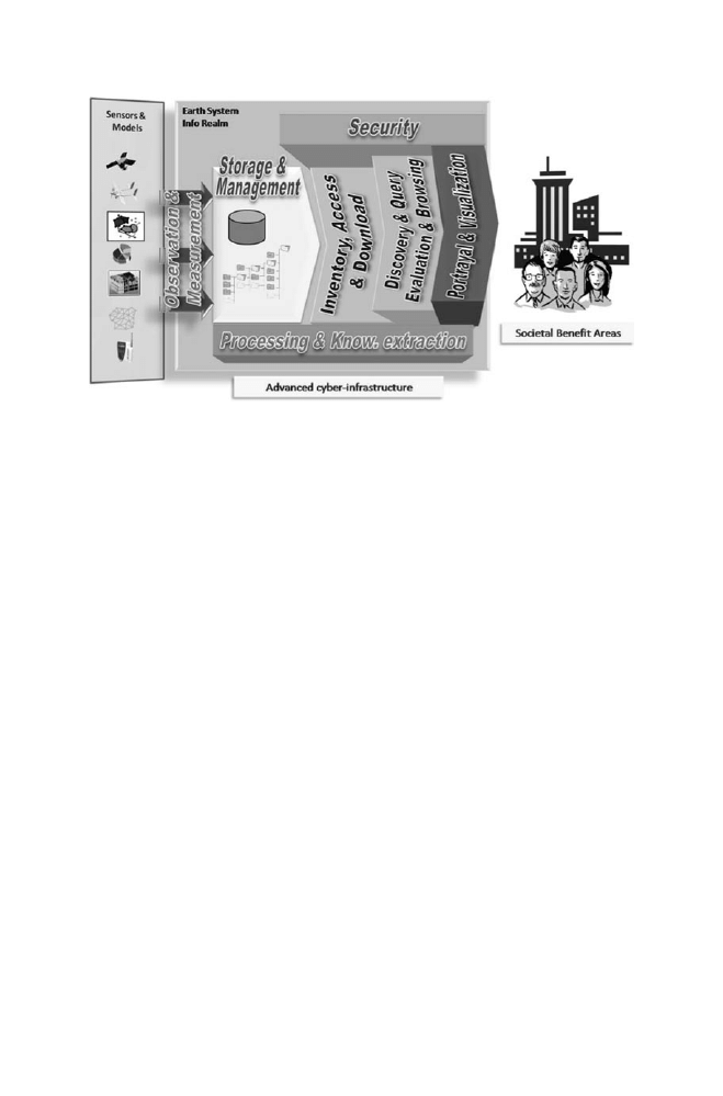
Earth science data infrastructures must consider a couple of other important
service categories: observation and measurement, and processing and knowledge
extraction services. They are important to interact with sensor and modeling
systems, to work out value-added products and serve policy makers. Figure
provides an overview of a general SDI for Earth science data.
As far as SDI architecture specification is concerned, the international standard-
ization process is based on a couple of well-accepted principles: to follow a Model
Driven Architecture (MDA) approach (Miller and Mukerji
) and implement it
as open distributed system (ISO 19101 2002; ISO/PDTS 19101-2; Nebert
).
8
http://www.isotc211.org/
9
http://www.opengeospatial.org/
10
http://www.wmo.int
11
http://seabass.ieee.org/groups/geoss/
220
S. Nativi et al.
ISO TC211 has been developing an MDA for geospatial information e-infrastruc-
tures; OGC has developed well-accepted service-oriented specifications to imple-
ment open distributed systems. These specifications process follows a standard
approach: the ISO Reference Model for Open Distributed Processing (RM-ODP)
(ISO/IEC 10746 1998), that uses an object modeling approach to describe distrib-
uted systems. In order to simplify the problems of design in large complex systems
five viewpoints provide different ways of describing the system. Highly simplified
RM-ODP Information, Computational, and Engineering views of the SIB-ESS-C
architecture are briefly described in the following sections. The RM-ODP Enterprise
view has been summarized in section 13.2.
13.4 Information View
This architectural view is concerned with information modelling. Thus the informa-
tion view defines the semantics of information and of information processing,
without having to worry about specific implementation details.
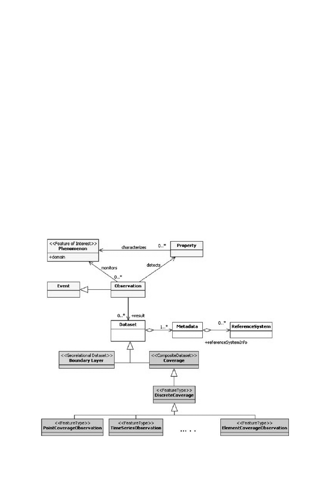
Information classes considered for SIB-ESS-C infrastructure are: discrete features,
coverages, observations and maps. According to MDA, the basic class of the infor-
mation conceptual model is the geospatial feature. In fact, a geospatial feature may
be defined as an abstraction of a real world phenomenon implicitly or explicitly
associated with a Earth location
(ISO 19107
). A coverage is a feature sub-
types which is defined by ISO as: a feature that associates positions within a
Fig. 13.2
Simplified architectural schema of an advanced infrastructure for Earth sciences
information (Color version available in Appendix)

221
13 Interoperability, Data Discovery and Access
bounded space (its domain) to feature attribute values (its range).
In other words, it
is both a feature and a function. Examples include a raster image, a polygon overlay
or a digital elevation matrix (ISO/FDIS 19123 2005).
13.4.1 Coverage Versus Features
Indeed the Earth sciences community deals with geospatial phenomena. Earth sci-
ences data capture and represent discrete and continuous real world phenomena.
Discrete phenomena are recognizable objects that have relatively well-defined
boundaries or spatial extent (e.g. measurement stations). While, continuous phe-
nomena vary over space and have no specific extent (e.g. temperature field); con-
tinuous phenomenon value is only meaningful at a particular position in space and
time. ISO TC211 introduced two fundamental data types to map real world phe-
nomena: features and coverages. Historically, geospatial information has been
treated in terms of two fundamental types called vector data and raster data. Vector
data deals with discrete phenomena, each of which is conceived of as a feature. The
spatial characteristics of a discrete real-world phenomenon are represented by a set
of one or more geometric primitives (e.g. points, curves, surfaces or solids) (ISO/
FDIS 19123 2005), whereas the other phenomenon characteristics are treated as
feature attributes. Generally, a single feature is associated with a single set of
attribute values. ISO 19107 provides a schema for describing features in terms
of geometric and topological primitives.
Raster data deal with real-world phenomena that vary continuously over space.
They contain a set of values, each associated with one of the elements in a regular
array of points or cells. Raster data are a commonly used example of Coverage. In
fact, the coverage concept generalizes and extends the raster structure type by refer-
ring to any data representation that assigns values directly to spatial position. A
coverage associates a position within a spatial/temporal domain to a value of a
defined data type. It realizes a function from a spatial/temporal domain to an attribute
domain (the co-domain) (ISO/FDIS 19123
13.4.2 Observations and Measurements
In addition to feature and coverage models, another relevant specification for Earth
sciences resources is the OGC Observation and Measurement information model
(Cox
). An Observation is defined as an event with a result which has a value
describing some phenomenon. The observation event is modelled as a feature
type within the context of the ISO general feature model (ISO 19101
; ISO
19109
). An observation results in an estimate of the value of a property of
the feature of interest; if the property varies on the feature of interest, then the result
is a coverage, whose domain is the feature. According to this best practise, in a physical
222
S. Nativi et al.
realisation the result will typically be sampled on the domain, and hence repre-
sented as a discrete coverage.
In summary, instruments and sensors observe and measure properties of feature of
interest (e.g. shape, position, temperature, height, density, direction, intensity, etc.).
Observations and measurements generate datasets; they can be modeled and stored as
either feature (i.e. boundary) or coverage data. This mainly depends on the observed
property variability over the domain which characterizes the feature of interest.
The SIB-ESS-C information model follows this approach managing and process-
ing both feature (i.e. boundary) and coverage datasets which stem from remote and
in-situ observations and measurements. Figure
depicts the SIB-ESS-C informa-
tion conceptual model. The model is expressed as a Unified Modeling Language
(UML) class diagram (ISO/IEC 19501
). UML is a well-accepted paradig-
matic modeling language used by domain experts. In fact, UML provides a collec-
tion of modeling constructs and an associated graphical notation for modeling a
problem domain as a class diagram. This is the reason why ISO TC211 selected
UML static structure diagram as part of its Conceptual Schema Language for rigorous
representation of geographic information.
With reference to the schema, a coverage acts as a function to return one or more
feature attribute values for any direct position within its spatiotemporal domain. A cover-
age dataset is characterized by a coverage function which associate a domain to range-set
Fig. 13.3
The general dataset conceptual model (Color version available in Appendix)

223
13 Interoperability, Data Discovery and Access
Table
13.1
SIB-ESS-C
data
products
EO
product
Source
Temporal
co
verage
Spatial
resolution
Spatial
co
verage
Partner
responsible
Phenology
SPO
T-V
GT
A
VHRR
2000–2003
annual
1
and
10
km
Entire
SIBERIA-II
Re
gion
Center
for
the
Study
of
the
Biosphere
from
Space
(CESBIO),
France
Disturbances
MODIS,
A
VHRR
A
TSR-2
1992–2003
on
yearly
basis
1
km
Entire
SIBERIA-II
Re
gion
Centre
for
Ecology
and
Hydrology
Monks
W
ood,
UK
Freeze/tha
w
QuikSCA
T
2000–2003
10
km
Entire
SIBERIA-II
Re
gion
TU
W
ien,
Institute
of
Photogrammetry
and
Remote
Sensing
(IPF),
Austria
W
ater
bodies
ASAR
WS
2003–2004
150
m
Entire
SIBERIA-II
Re
gion
TU
W
ien,
Institute
of
Photogrammetry
and
Remote
Sensing
(IPF),
Austria
Sno
w
depth
SSM/I
2000–2003
25
km
Entire
SIBERIA-II
Re
gion
Center
for
the
Study
of
the
Biosphere
from
Space
(CESBIO),
France
Sno
w
melt
SSM/I
2000–2003
25
km
Entire
SIBERIA-II
Re
gion
Center
for
the
Study
of
the
Biosphere
from
Space
(CESBIO),
France
Land
co
ver
MODIS
2001–2004
annual
500
m
Entire
SIBERIA-II
Re
gion
Uni
versity
of
W
ales
Sw
ansea,
UK
Continuous
field
land
co
ver
MODIS
VCF
MODIS
LC
2003
500
m
Entire
SIBERIA-II
Re
gion
Friedrich-Schiller
-Uni
versity
Jena,
Institut
for
Geograph
y,
German
y
Topograph
y
SR
TM/GT
OPO
2000
3
arcsec
<
60°
N
Entire
SIBERIA-II
Re
gion
Gamma
Remote
Sensing
A
G,
Switzerland
1
km
>
60°
N

224
S. Nativi et al.
values. Spatial referencing is based on coordinates; spatial references relate the features
represented in the data to positions in the real world (ISO 19111
).
13.4.3 Data Products
The data products currently available through the SIB-ESS-C infrastructure were
created by a number of research institutions teamed up in the EU-funded
SIBERIA-II project (2002–2005). The objective of SIBERIA-II Earth observation
was to deliver geo-observational products that aid in improving the modeling
approaches and in turn address the key scientific questions of the project: What is
the current average greenhouse gas budget of the region and what is its spatial and
temporal variability? How will it change under future climatic and anthropogenic
impacts? To achieve the goals of the SIBERIA-II project, a diverse set of multi-
sensor Earth observation data was used. The definitions of land surface products to
be derived from EO data, their spatial and temporal scales were geared towards the
project modeling approaches. Table
summarizes the main properties of the
data products available. For a more detailed product descriptions refer to (Delbart
et al.
; George et al.
; Bartsch et al.
; Bartsch et al.
; Grippa
et al.
; Skinner and Luckman
). All data products cover at least a three
million square kilometer area in central Siberia defined by the administrative bound-
aries of the Krasnoyarsk Kray, Irkutsk Oblast, Taymyr and Evenk Okrug. The
temporal coverage is usually for four consecutive years (2000–2003). Extending these
time series according to the availability of the Earth observation data is intended.
13.4.4 Metadata
Spatial data infrastructures manage and share datasets: they consist of data along
with its description: the metadata – data about data. Metadata are crucial to enable
data cataloguing allowing its discovery, evaluation and correct use. Metadata allows
data localization, extraction, integration and employment. In summary, metadata is
important to understand the right data for the right purpose.
To follow a multi-disciplinary geospatial information standard was essential to
provide an understanding of data across the different information communities that
contribute to SIB-ESS-C. Therefore, SIB-ESS-C adopted ISO 19115 (ISO 19115
)
as its metadata reference standard. In fact, 19115 provides a structure for describing
digital geospatial data and services, defining general-purpose metadata. This standard
models information about the identification, the extent, the quality, the spatial and
temporal schema, the spatial reference, and the distribution of data. Metadata must
be provided for independent datasets, aggregations of datasets, individual geo-
graphic features and coverages. GEOSS, GMES and INSPIRE adopts ISO 19115
for their cataloging services.

225
13 Interoperability, Data Discovery and Access
19115 defined set of metadata elements is quite extensive; thus, only a subset of
the full number of elements is generally used, according to the domain and system
requirements. For its initial infrastructure, SIB-ESS-C maintains the basic minimum
number of metadata elements recommended by the ISO 19115 specification itself,
plus few extra elements. These set of minimum metadata elements is called the 19115
“core profile”; it fits to identify a dataset for catalogue purposes. Significant elements
of SIB-ESS-C metadata are listed in Table
along with the respective obligation;
they focus on dataset; metadata on metadata are not listed.
13.4.5 Dataset Encoding
At the present development stage data products are provided in GeoTIFF or ESRI
Shapefile format. For all data products metadata complying with the ISO 19115
standard is available. Data sets available from the SIB-ESS-C infrastructure are
provided free of charge following a simple user registration procedure.
13.5 Computational and Engineering Views
The Computational viewpoint describes the system decomposition in main functional
components interacting through well-defined interfaces, according to the SOA. The
Engineering viewpoint is concerned with the design of distribution-oriented
aspects, that is, the infrastructure required to support distribution. It focuses on the
mechanisms and functions required to support distributed interaction between com-
ponents in the system. In keeping with the advanced infrastructure for Earth sciences
information depicted in Fig.
, the present SIB-ESS-C infrastructure services may
be organized in the following functional tiers:
Table 13.2
Significant SIB- ESS-C metadata (with respective obligation)
Dataset reference date (mandatory)
Abstract describing the dataset (mandatory)
Geographic location of the dataset by four coordinates -the
minimum bounding rectangle vertexes (mandatory)
Dataset topic category (mandatory)
Additional extent information for the dataset (vertical and
temporal) (mandatory)
Distribution format (mandatory)
Dataset language (mandatory)
Spatial representation type
(optional)
Reference system (optional)
Lineage (optional)
On-line resource (optional)
Spatial resolution of the dataset
(optional)
Dataset responsible party
(optional)

226
S. Nativi et al.
Data Storage & Management
•
Data Processing & integration services
•
Data Access services
•
Data Discovery & Query services
•
Data Browsing and Evaluation Services
•
Data Portrayal and Visualization services
•
Data Download services
•
The general design strategy pursued for SIB-ESS-C is to implement a service-ori-
ented infrastructure adopting the interface standards published by the OGC, apply-
ing the ISO TC211 models and resorting to the W3C solutions in order to achieve
interoperability with other information systems. The development has focused on
the implementation of free and open source software whenever possible and to
utilize existing components that are well established in the Earth sciences, Earth
Observation and GIS communities.
Service-Oriented Architecture is based on the notion that it is beneficial to decom-
pose a large problem into a collection of smaller, related pieces: services. This helps
to establish a high form of abstraction that encapsulates both application and process
logic. For the Earth system domain a service-oriented architecture offers considerable
flexibility in aligning information technology functions and processes. SOA is a flex-
ible, extensible architectural framework that enables rapid application delivery and
integration across organizations and “siloed” applications (Arsanjani et al.
In SOA, a service provider publishes a description of the service(s) it offers via
a service registry. Service consumer, which may be either a person or process,
searches the service registry to find a service that meets a particular need. The goal
is total modularization of the distributed computing environment as opposed to
recreating the large monolithic solutions of more traditional platforms (Snell et al.
). This paradigm is useful for efficiently organizing and utilizing distributed
capabilities that may be under the control of different ownership domains, as is the
case in GEOSS, GMES and INSPIRE. It provides a uniform means to offer, dis-
cover, interact with and use heterogeneous resources. Services interoperability is
achieved by applying standard service interfaces based on data and metadata mod-
els. We already discussed the data and metadata models in the information view. As
for the service interfaces, the SIB-ESS-C infrastructure provides three major
service types: resource discovery, access and analysis. They are achieved by imple-
menting standard interfaces like the OGC access protocols. These protocols specify
the standard interface functionalities to access and subset feature and coverage-
based datasets as well as generic maps (i.e. pictorial images), namely: the Web
Feature Service (WFS), the Web Coverage Service (WCS), and the Web Map
Service (WMS). However, for specific Earth science disciplinary data well-
accepted best practices (i.e. community standards) are implemented, as well.
Examples include the CF-netCDF,
12
OPeNDAP,
13
or THREDDS (Nativi et al. 2006)
12
http://badc.nerc.ac.uk/help/formats/netcdf/index_cf.html
13
http://www.opendap.org/
227
13 Interoperability, Data Discovery and Access
data and protocol models for the fluid Earth sciences, and the TDWG
14
standards
for the Biodiversity and Ecology communities.
13.5.1 Resource Discovery Service
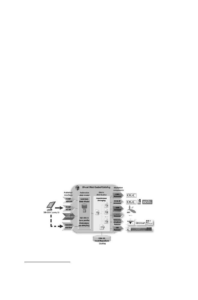
The resource discovery service of SIB-ESS-C utilizes a federated catalogue providing
a standard OGC discovery interface: the Catalog Service for Web (CS-W) inter-
face (OGC 07–006r1 2007). It implements the ISO 19115 metadata model
described in the system information view. The CS-W is the emerging standard for
cataloguing services in geomatics, and its ISO Application Profile (OGC 07–045
2007) is the INSPIRE candidate recommendation for discovery services.
This enables users to perform queries on external catalogues and in turn allows
other registries to harvest information about SIB-ESS-C data holdings and services.
The implementation of the SIB-ESS-C catalogue is based on an open technology:
the GI-cat server (Bigagli et al.
; Nativi et al.
). An ad-hoc module was
added to GI-cat base implementation in order to directly access the database con-
taining the SIB-ESS-C 19115 metadata.
GI-cat is an open solution for developing catalog components which implement
distributed discovery, data model mediation and access services. GI-cat provides a
consistent interface for querying heterogeneous catalogs and data providers that
implement international geospatial standards and special arrangements, making it
possible to federate heterogeneous data sources by specifying mediation rules for
interoperability. GI-cat is a federated catalog providing a unique and consistent
interface that enables the interrogation of heterogeneous data resources. GI-cat
exposes an OGC CS-W standard interface and is able to federate heterogeneous
catalogs and access servers that implement international geospatial standards, such
14
http://wiki.tdwg.org/twiki/bin/view/DarwinCore/DarwinCoreDraftStandard
Fig. 13.4
SIB-ESS-C components architecture implementing the discovery and access services
(Color version available in Appendix)

228
S. Nativi et al.
as the OGC Web services (e.g. WCS, WMS, CS-W). In addition, GI-cat implements
a mediation server, making it possible to federate components which imple-
ment Community standard services (e.g. THREDDS/OPenDAP and GBIF ser-
vices). Other functionalities provided by GI-cat are metadata persistency, based on
the ISO 19115 data model, and the session and cache management.
The components architecture for the SIB-ESS-C discovery and access services
is depicted in Fig.
13.5.2 Resource Access Services
Access to SIB-ESS-C data products is provided through OGC Coverage -, Feature-
and Map Services allowing users to directly integrate the data as a service into their
application or retrieve a file of the requested data product. Access is granted free of
charge after a user registration procedure.
13.5.3 Data Visualization Service
A lightweight web interface based on AJAX technologies was developed to directly
access SIB-ESS-C service capabilities. From the list of data products returned by
the resource discovery service user can select one or more datasets. Resource
access services are used to generate a map view (within a Web browser) of these
data sets along with auxiliary data supporting orientation and navigation within the
view. Moreover, GI-cat publishes a standard catalog interface (i.e. the CS-W ISO
interface); thus, any client application which implements such protocol can access
the SIB-ESS-C infrastructure being able to discover, query, access, download and
visualize the registered datasets.
13.5.4 Data Analysis Services
An advanced feature of SIB-ESS-C will be the online analysis tool to investigate
spatial and temporal characteristics (e.g. changes/trends over time) of data prod-
ucts and their relationships (e.g. cross-correlation) or to assess uncertainty of
parameters by intercomparing data products from multiple sensors and algorithms.
The system provides a Web interface to investigate spatial and temporal character-
istics (e.g. changes/trends over time) of data products and to compare data prod-
ucts from multiple sensors and algorithms. A user selects one or two datasets
(using the resource discovery service) and specifies the spatial and temporal cover-
age as well as the analysis method. According to the analysis method selected the
system returns a graphical representation of the data set (e.g. time series plot,

229
13 Interoperability, Data Discovery and Access
map).This service will be available for existing SIB-ESS-C data products, but also
for external data sets if they are provided through an OGC access service (i.e.
WCS and WFS). SIB-ESS-C is investigating the implementation of the standard
Web Processing Service (WPS) interface to run data processing, publishing these
modules on the Web.
13.5.5 Services Infrastructure Interoperability
The adoption of standard service interfaces allows the SIB-ESS-C infrastructure to
contribute to other international efforts, in particular: the Global Change Master
Directory (GCMD) and the GEOSS portal.
The GCMD is a comprehensive directory of information about Earth science
data and related tools/services, many of which are targeted for the use, analysis, and
display of the data. The directory metadata model (i.e. Directory Interchange
Format) is compatible with ISO 19115 standard. The GCMD is supported by
NASA and contributes to the Committee on Earth Observation Satellites (CEOS).
SIB-ESS-C will register its standard components and services to the respective
GEOSS Registries. In fact, the infrastructure implemented services and standards
are recognized and supported by GEOSS.
Presently, the SIB-ESS-C infrastructure follows the vision of the implementa-
tion rules under specification by the INSPIRE initiative.
13.6 Future Research Activities
A few research aspects to be possibly investigated in the future are: distributed
discovery services based on Peer-to-Peer technologies, advanced access services
for multidimensional data, and integration of forecasting models via OGC WPS
interface. Another possible topic of further activity is the visual presentation of
Earth Observation data, typically coverages, that is hard to implement in the gen-
eral case due to the complexity and heterogeneity of data structures and
formats.
References
ISO/IEC 10746 (1998) Open Distributed Processing – Reference Model
ISO/PDTS 19101-2 Geographic information – Reference model – Part 2: Imagery. TC211 working
document
OGC 07-045 (2007) Catalogue Services Specification 2.0.2 – ISO Metadata Application Profile,
Ver. 1.0.0
OGC 07-006r1 (2007) OpenGIS® Catalog Services Specification, Ver. 2.0.2

230
S. Nativi et al.
Arctic Climate Impact Assessment (2004) Impacts of a warming Arctic: Arctic climate impact
assessment. Cambridge University Press, Cambridge
Arsanjani A, Zhang L, Ellis M, Allam A, Channabasavaiah K (2007) S3: A Service-Oriented
Reference Architecture. IEEE IT Pro May–June 2007, pp 10–17
Bartsch A, Kidd RA, Wagner W, Bartalis Z (2007a) Temporal and spatial variability of the beginning
and end of daily spring freeze/thaw cycles derived from scatterometer data. Remote Sens
Environ 106(3):360–374
Bartsch A, Kidd R, Pathe C, Wagner W, Scipal K (2007b) Satellite radar imagery for monitoring
inland wetlands in boreal and sub-arctic environments. J Aquat Conserv: Mar Freshwater
Ecosyst 17:305–317
Bigagli L, Nativi S, Mazzetti P, Villoresi G (Sept 2004) GI-Cat: a Web Service for Dataset
Cataloguing Based on ISO 19115. In: Proceedings of the 15th International Workshop on
Database and Expert abase and Expert Systems Systems Applications, IEEE Computer
Society Press, Zaragoza (Spain). ISBN 0-7695-2195-9, pp 846–850
Cox S (ed) (2006) Observations and measurements. OGC Best Practices, OGC® 05-087r4
Delbart N, Kergoat L, Le Toan T, L’Hermitte J, Picard G (2005) Determination of phenological
dates in boreal regions using normalized difference water index. Remote Sens Environ
97(1):26–38
IEEE (1990) IEEE Standard Computer Dictionary: a Compilation of IEEE Standard Computer
Glossaries. New York, NY
Foster I, Kesselman C (Nov 2006) Scaling system-level science: scientific exploration and IT
implications. IEEE Comput 39(11)
GEO (2005) In: Battrick B (ed) Global Earth Observation System of Systems (GEOSS) 10-Year
Implementation Plan. ESA Publications Division, the Netherlands. ISSN No.: 0250-1589, ISBN
No.: 92-9092-495-0
GEO (2007) 2007–2009 Work Plan: Toward Convergence, GEO document
George C, Rowland C, Gerard F, Balzter H (2006) Retrospective mapping of burnt areas in Central
Siberia using a modification of the normalised difference water index. Remote Sens Environ
104(3):346–359
EC (2005) GMES: From concept to reality. Communication from the Commission to the Council
and the European Parliament, November 11 2005. http://www.gmes.info/library/files/1.%20
GMES% 20Reference%20Documents/COM-2005-565-final.pdf.
Grippa M, Mognard NM, Le Toan T, Josberger EG (2004) Siberia snow depth climatology derived from
SSM/I data using a combined dynamic and static algorithm. Remote Sens Environ 93:30–41
Hansen J, Ruedy R, Glascoe J, Sato Mki (1999) GISS analysis of surface temperature change.
J Geophys Res 104:30997–31022
ISO 19101 (2002) Geographic information – Reference model
ISO 19107 (2003) Geographic information – Spatial schema
ISO 19109 (2005) Geographic information – Rules for application schema
ISO 19111 (2003) Geographic information – Spatial referencing by coordinates
ISO 19115 (2003) Geographic information – Metadata
ISO/FDIS 19123 (2005) Geographic information – Schema for coverage geometry and functions
ISO/IEC 19501 (2005) Information technology – Open distributed processing – Unified Modeling
Language (UML) Version 1.4.2
Khalsa SJS, Nativi S, Geller G (2008) The GEOSS Interoperability Process Pilot Project (IP3).
Submitted to IEEE TGRS
Miller J, Mukerji J (eds) (June 2003) “MDA Guide Version 1.0.1” OMG Document Num.
omg/2003-06-01
Nativi S, Domenico B, Caron J, Bigagli L (June 2006) Extending THREDDS middleware to
serve OGC community, Advances in Geosciences. J Eur Geosci Union, 8:57–62. SRef-ID:
1680-7359/adgeo/2006-8-57
Nativi S, Bigagli L, Mazzetti P, Mattia U, Boldrini E (July 2007) Discovery, query and access
services for Imagery Gridded and Coverage Data: a clearinghouse solution. In: IEEE
International Geoscience and Remote Sensing Symposium, Barcelona, Spain

231
13 Interoperability, Data Discovery and Access
Nebert D (ed) (2004) Developing spatial data infrastructures: the SDI cookbook ver. 2.0. GSDI
publication
Percival G (2008) GEOSS Architecture Implementation Pilot. In: Proceedings of the ’08 EGU
General Assembly meeting, Vienna, April 2008
Skinner L, Luckman A (2004) Introducing a land cover map of Siberia derived from MERIS and
MODIS data. In: Proceedings of IGARSS’04, Anchorage, 20–24 Sept, pp 223–226. G. O
Snell J, Tidwell D, Kulchenko P (Jan 2002) Programming Web Services with SOAP. O’Really
edition. ISBN 0-596-00095-2, pp 244
Zhaomei Z, Zhongwei Y, Duzheng Y (2001) The regions with the most significant temperature
trends during the last century. Adv Atmos Sci 18(4):481–496
Document Outline
- Chapter 13: Interoperability, Data Discovery and Access: The e-Infrastructures for Earth Sciences Resources
Wyszukiwarka
Podobne podstrony:
1b The Literature of Discovery and Exploration
Access to History 002 Futility and Sacrifice The Canadians on the Somme, 1916
13 examples of good and?d manners around the World
INTRODUCTION OF THE PERSONAL DATA PRIVACY AND SECURITY ACT OF 2014
British Patent 13,563 Improvements in, and relating to, the Transmission of Electrical Energy
The House furniture, appliances and accessories
(13) Meditation and Conditioning (The Meditation)
Kwiek, Marek The Two Decades of Privatization in Polish Higher Education Cost Sharing, Equity, and
Data Mining Ai A Survey Of Evolutionary Algorithms For Data Mining And Knowledge Discovery
Functional improvements desired by patients before and in the first year after total hip arthroplast
Why the Nazis and not the Communists
Extensive Analysis of Government Spending and?lancing the
A picnic table is a project you?n buy all the material for and build in a?y
Foucault Discourse and Truth The Problematization of Parrhesia (Berkeley,1983)
Politicians and Rhetoric The Persuasive Power of Metaphor
Preparing for Death and Helping the Dying Sangye Khadro
59487272 Accessing the WAN Student Skills Based Assessment Lab Answer Key
więcej podobnych podstron