
BRONZE AGE ROCK ART AND BURIALS IN WEST NORWAY
ARTE RUPESTRE Y ENTERRAMIENTOS EN EL OUEST DE LA NORUEGA EN LA
EDAD DE BRONCE
Melanie WRIGGLESWORTH *
Resumen
Se discute la relación entre petroglifos y enterramientos de la Edad de Bronce en el área occidental de Noruega y se pre-
senta un método visual para el análisis del paisaje. Los petroglifos y los enterramientos son interpretados a la luz de la
cosmología y rituales funerarios.
Palabras clave:
arte rupestre, tumbas, paisaje, relaciones visuales, cosmología.
Abstract
In this paper I discuss the relationship between rock art panels and burial cairns from the Bronze Age in West Norway.
The method used is a visual landscape analysis, based on landscape architecture and psychology of perception. The rock
art panels and the cairns are interpreted in terms of funerary rituals and cosmology.
Key words:
Rock art, graves, landscape, visual relationships, cosmology
Traditionally, rock art researchers have focused on the meaning and interpretation of rock carvings as
well as the classification and quantification of motifs. However, in recent years, interest has shifted
to the archaeological context of the rock art and the relationship between rock art and the landscape
as well as between rock art and other types of monuments. Although rock carvings are difficult to
interpret, we may learn more by relating rock art to the landscape in which it is found, as well as to
other monuments. If we understand the social context of the rock art, we may understand some of its
meaning as well. In this paper, I will discuss the relationship between Bronze Age rock art and cairns
and their relationship to the landscape in Askvoll, Sogn & Fjordane County, West Norway
(Wrigglesworth 2000). In this area, the rock art is found near a large number of burials dated to the
Bronze Age (1700-500 BC).
Both rock art and burials have been studied in terms of landscape and its influence on prehistoric
people (Mandt 1978; Sognnes 1987, 1994, 1998; Hood 1988; Bradley 1993, 1997, 2000; Taçon 1994;
Tilley 1994, 1999, 2004; Gansum 1995, Vevatne 1996; Vogt 1998; Østerdal 1999). However, the term
landscape is difficult to define, as it encompasses many different aspects. Landscape can be the natu-
ral (physical) landscape, or a mindscape, a soundscape, a smellscape etc. Here, I define landscape as
a series of places that embody “… (literally and metaphorically) emotions, memories and associations
derived from personal and interpersonal shared experience” (Tilley 1999:177). This enables a discus-
sion of the relationship between places as well as between monuments.
@
rqueología y Territorio nº 4. 2007. pp. 251-261
* Bergen Museum. University of Bergen melanie.wrigglesworth@bm.uib.no
@
rqueología y Territorio nº 4. 2007. pp. 251-261
M WRIGGLESWORTH. Bronze age rock art and burials in West Norway
• 252
THE ARCHAEOLOGICAL CONTEXT
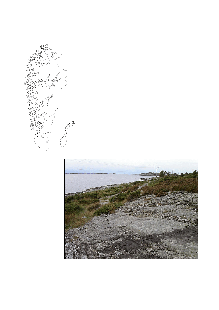
Three sites comprising 18 rock art panels in Askvoll in Sogn &
Fjordane county were selected for analysis: Unneset (10 panels),
Leirvåg (six panels) and Mjåset (two panels). The panels at Unneset
are located at Staveneset, a headland that is also the westernmost
point in West Norway (fig. 1). A panoramic view encompasses the
North Sea, small islands and skerries as well as the fjord. The main
shipping lane passes Staveneset. To the north there is a stretch of
rough open sea, which can be hard to cross, particularly in bad wea-
ther. Mjåset is located along the Stongfjord, a few kilometres from
Staveneset. There is a good view of the fjord as well as the shipping
lane. The panels at Leirvåg, on the island of Atløy, are found at two
separate locations: Leirvåg 1-2, 6 are located at Ytre Naustvikja, a
small bay, while Leirvåg 3-5 are located at Leirvågneset, a small
promontory. Again, the shipping lane passes the sites.
The rock art panels are located between 4 and 6 m.a.s.l. and are all
found on outcrops in the shore area (fig 2). One panel is found in a
secondary position at 15 m.a.s.l. There is no reliable shoreline data
available for this area; however, I used a computer programme
developed at the University of Tromsø, Norway
1
to give an estima-
te of the shoreline in the area, indicating a difference of about 5
@
rqueología y Territorio nº 4. 2007. pp. 251-261
1 Sealev 32, University of Tromsø, Department of Geology.
Figure 1. Map of
West Norway
showing the
study area.
Figure 2. The landsca-
pe, a rock art panel is
in the foreground
@
rqueología y Territorio nº 4. 2007. pp. 251-261
M WRIGGLESWORTH. Bronze age rock art and burials in West Norway
• 253
metres from the present shoreline. This means that in the Bronze Age, the panels would have been
located at the water’s edge, and may even have been submerged at high tide. Today, some carvings at
Leirvåg 3 are sprayed by water at extreme high tide. All panels face south toward the sea and the
shipping lane; at Unneset, only outcrops with bands of quartz appear to have been selected for pro-
ducing carvings.
The dominating motifs are ships and cup marks; there are also footprints, rings, anthropomorphic
representations, a chariot, and various geometric motifs. Two small panels have cup marks only.
Natural lines and crevices are sometimes incorporated into the carvings, e.g. at Unneset 7, where a
crack in the rock surface forms the keel of a boat. The majority of the rock art is dated to the middle
of the Bronze Age; however, some boats are dated to the Early Bronze Age (Mandt 1991; Wrigglesworth
2000, 2002). The close proximity to the sea and the fact that the majority of the carvings depict boats
can be seen as a maritime rock art tradition in this area.
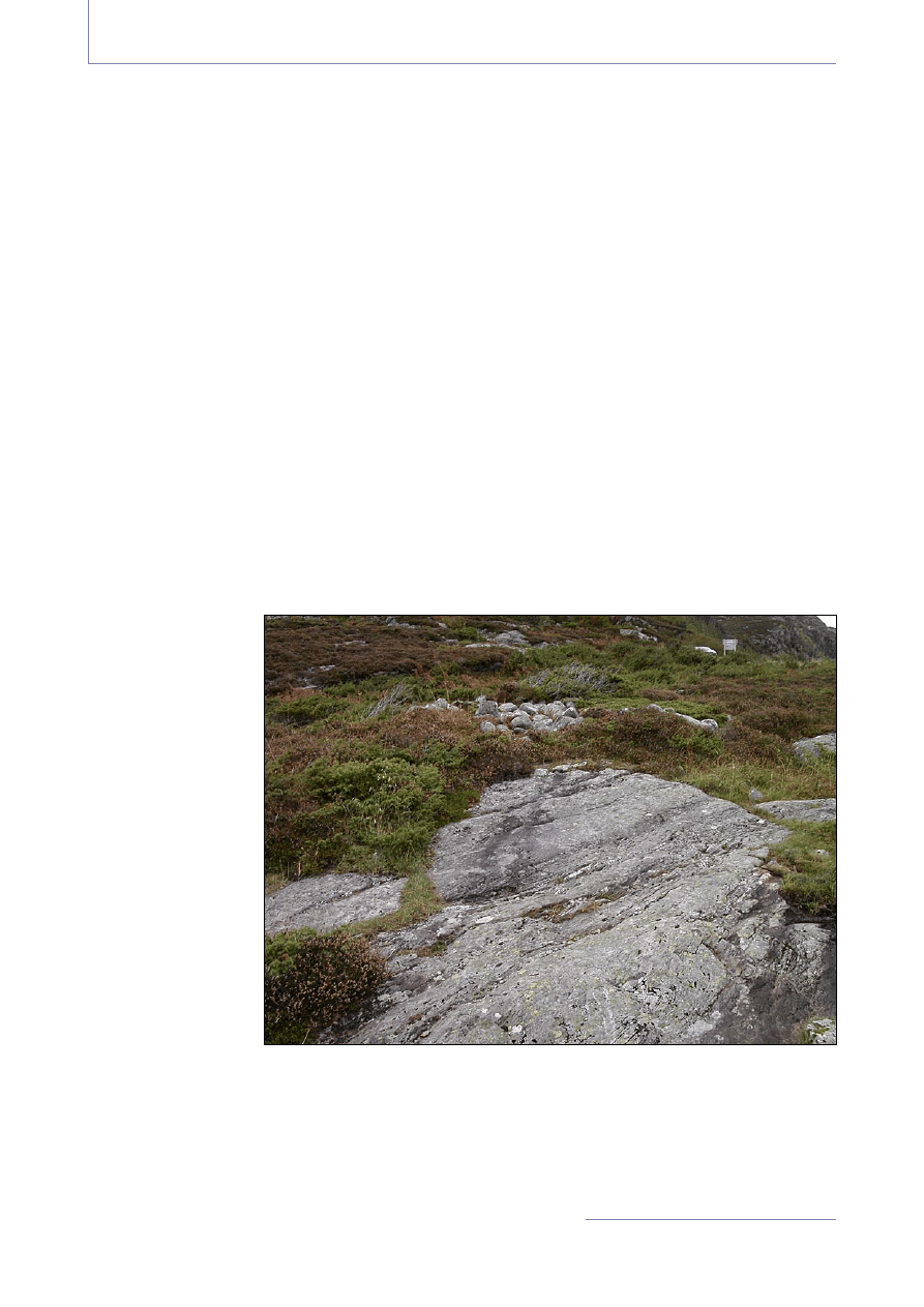
There are a number of cairns at Unneset and Leirvåg. My objective was to see whether a relationship
between the rock art panels and the burials could be established. In addition to the cairns near the rock
art, all burials that could be dated to the Bronze Age or had a possible Bronze Age date were selected
for analysis. In total, 69 burials were selected, 40 of which are located near rock art panels. The largest
site is Unneset, where 34 cairns are found along a short distance. Most of those burials are found
within a 25 m radius of any given panel, in one case a cairn is found just above the panel (fig 3). Most
of the cairns are damaged or covered by vegetation, and as there are no finds from the cairns, their
date can only be established by construction details and location. Three cairns have been excavated,
of which only one
could be dated to
the Bronze Age;
none were located
near rock art panels.
A flint dagger and a
stone axe have been
found in contexts
that indicate burials,
from the Early
Bronze Age and the
Late Bronze Age
respectively. The
cairns are generally
located at 5-20
m.a.s.l., near the
sea or in places
where there is a
good view of the
sea and surroun-
ding landscape.
Figure 3. A burial, visible as a small collection of stones, is located above a
rock art panel

@
rqueología y Territorio nº 4. 2007. pp. 251-261
M WRIGGLESWORTH. Bronze age rock art and burials in West Norway
• 254
THE METHOD: VISUAL LANDSCAPE ANALYSIS
The analysis of the rock art and the burials was carried out using visual landscape analysis, a method
developed by Gansum, Jerpåsen & Keller (1997). This method offers both a terminology and a
methodology for studying the landscape. It should be emphasised that the method is not used to
analyse monuments, but the places where monuments are located and the qualities of those places.
This means that the relationship between rock art panels and burials in the study area can be descri-
bed through an analysis of visual relationships in the landscape. By systematically analysing the
location of rock art panels and the burials, an underlying pattern may be uncovered, which in turn
may shed some light on the meaning of the rock art and how the landscape was perceived and used
in the Bronze Age.
Visual landscape analysis is based on landscape architecture (Lynch 1992) and psychology, in order
to describe how people perceive the landscape. A central concept is orientation, that is, how people
structure and recognize their surroundings (Gansum et al 1997:11). Although the landscape is expe-
rienced individually, the experience is part of a larger cultural framework, where experience is cons-
tructed socially and culturally. Knowledge of the landscape is thus based on both personal and cultu-
ral experience. Landscape perception is another key concept – people do not see the landscape as a
single unit, they select elements that they “see” and to which they ascribe meaning. Consequently, the
elements that individuals notice and the meaning that they attribute to those elements are social and
cultural constructs.
The concept of the landscape room is fundamental in visual landscape analysis. Using an analogy
from architecture, the landscape is seen as an empty room, where the sky is the ceiling, the ground is
the floor and mountains, hills etc. constitute the walls. The landscape room is defined by a continuous
flat surface and is delimited by the walls or by a change in the ground so that a visual discontinuity
or a visual barrier is formed. The floor may be broken by an edge or a line. An edge is a sharp visual
barrier in the terrain, while a line is a weaker barrier (Gansum et al. 1997:13). The landscape room
and its perception are thus structured by topography. There are small-scale and large-scale landscape
rooms, as well as superior and inferior rooms, where a superior landscape room can consist of several
inferior rooms. How a landscape room is perceived depends on the position of the observer, it is the
point from where the observations are made that determines how the room is perceived and defined.
It is important to note that this method is subjective and only describes how the observer perceives
the landscape; it is a tool for describing features in the landscape rather than an accurate description
of a prehistoric reality. The modern landscape is different from the prehistoric landscape, as it is the
result of hundreds or thousands of years of development. Pollen analysis can indicate the type of
vegetation in the area to be studied, but it can give no information as to where the vegetation was
located. Consequently, visual landscape analysis can only be used to describe the main landscape
elements, such as mountains and hills, rather than smaller features. In the case of Askvoll, where the
majority of the monuments are found in a typical coastal landscape, it is likely that the Bronze Age
landscape has not differed greatly from the present landscape.
The analysis is carried out by defining landscape rooms and observing the various qualities of a place,
assigning a set of codes to the location of each monument describing those qualities. The following
terms are used to describe the qualities of place:
Extrovert:Introvert
describes whether the superior landscape room can be seen from the place.

@
rqueología y Territorio nº 4. 2007. pp. 251-261
M WRIGGLESWORTH. Bronze age rock art and burials in West Norway
• 255
Public:Private
describes visibility of a place from the landscape room – a place is public if it
can be seen from either the superior or interior landscape room, while it is private if the visibi-
lity from the landscape room is poor.
Exclusive:Inclusive – a place is classified as exclusive if building new monuments near an
existing monument is impossible, while it is inclusive if there is room for new monuments. A
rock art panel will always be exclusive, particularly in the study area, as it is confined to a par-
ticular outcrop.
THE VISUAL LANDSCAPE
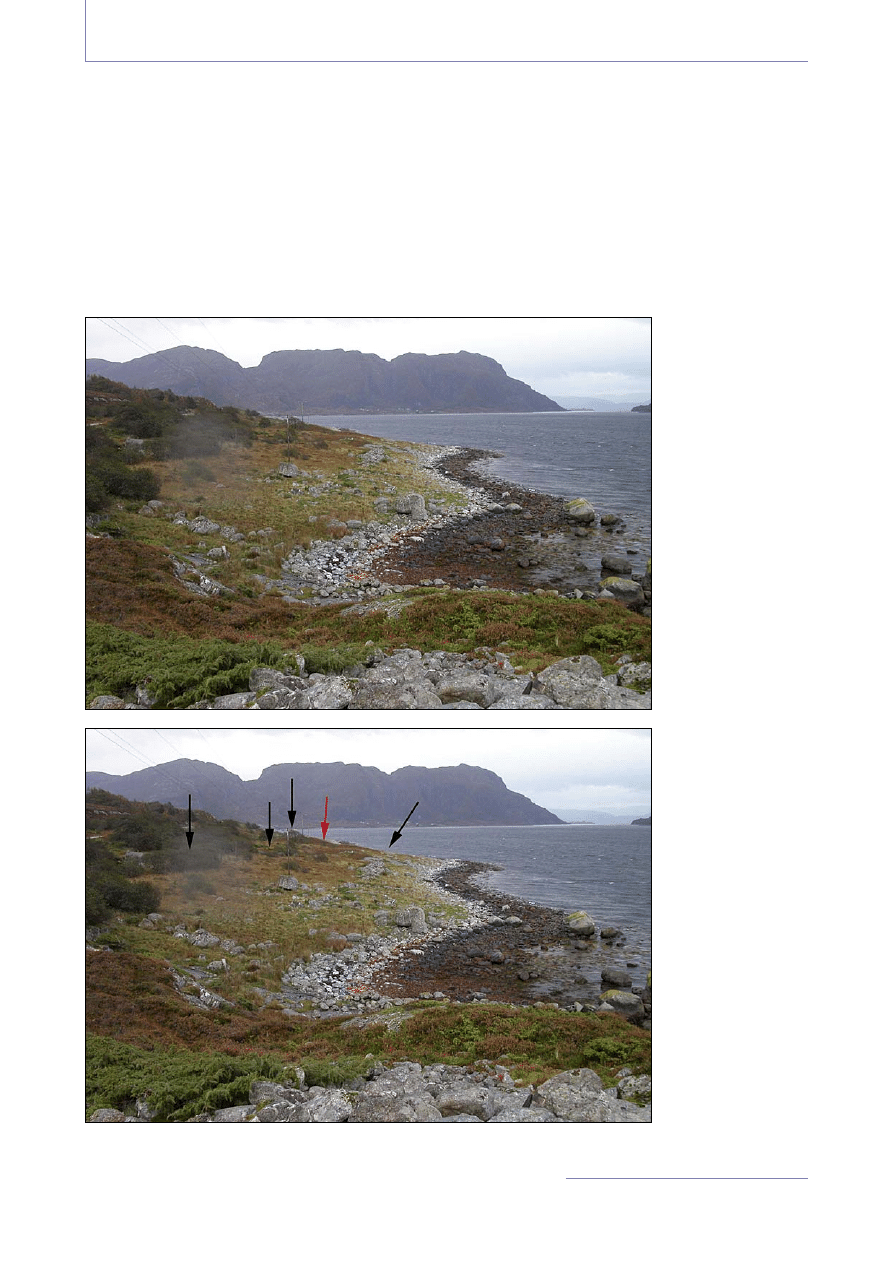
The analysis showed that the rock art is found at or near edges in the landscape, such as the water’s
edge or on outcrops that form a sharp visual barrier or discontinuity. These edges form the boundaries
between two or several inferior landscape rooms. The places where the panels are found are visible
from a distance because the rock outcrops form clear visual barriers in the landscape, and the panels
are visible from the entire landscape room, or most of the room (fig 4). The panels that are located
between two rooms address more than one room at the same time, and thus their location is extrovert,
public and exclusive. My interpretation is that these panels are public, i.e. that they were meant to be
seen when moving along the shore. In other words, these sites were available to a larger group of
people, and the ritual of making rock art could have been a collective experience. All panels are acces-
sible, they can be reached from all directions, although the carvings are generally visible when one
stands in front of the panel. One panel, Leirvåg 4, is coded as private as it cannot be seen from a dis-
tance when approached from land, and is only visible when standing directly in front of the rock. This
would have been rather difficult, as the only place where it is possible to view the images is a small,
narrow ledge in the rock face. As the sea level would have been a few metres higher in the Bronze
Age, it is likely that this panel was intended to be seen from the water only. However, it would still
have been accessible to a larger group. Above this panel, the rock forms a natural amphitheatre and it
is tempting to interpret this as a public arena where a larger group could assemble for ceremonies.
The panels generally address a local area, that is, the inferior landscape room, but as they are located
at edges that are visible over large distances they also have a greater effect in the landscape, although
they do not dominate their surroundings. All panels address the sea and the main shipping lane. The
places can be seen from a passing boat; however, this does not mean that the rock art was meant to
be seen from the sea or from the superior landscape room. The outcrops blend into the rocky terrain
and are difficult to distinguish; the rock carvings are difficult to see unless one moves close to the
panels. This indicates that the view from the panels may have been more important than the view of
the panels from a distance; passers-by would most likely have had prior knowledge of the sites and
know where to look.
A similar pattern emerged for the cairns. They are generally found on hillocks and slopes that have a
clear profile in the landscape, forming sharp visual barriers. The barriers also act as boundaries bet-
ween two inferior landscape rooms, and the cairns are visible from most of the room. The cairns are
generally located at extrovert, public and exclusive places; they dominate the landscape and have a
monumental effect within the inferior landscape room. Some cairns were located in inclusive places,
as there is room for more than one monument. However, rarely more than one monument was built
in those places, with the exception of one group of seven cairns. There is a high degree of visibility
@
rqueología y Territorio nº 4. 2007. pp. 251-261
M WRIGGLESWORTH. Bronze age rock art and burials in West Norway
• 256
between the cairns as well; it is generally possible to see at least one monument – a cairn, a rock art
panel or both, as well as places where other monuments are located – from every cairn. My interpre-
tation is that they are public and were intended to be seen; there is at least a visual relationship between
the two types of monument. The cairns address the sea and the shipping lane, in some cases having a
panoramic view of the coast. However, unless one sails quite close to the shore, the cairns are difficult
to spot from the sea as they blend into the rocky terrain. This is especially the case at Unneset, where
the cairns can be hard to see even from the shore (fig 4 and 5). The view from the cairns thus appears
to have been more important than the view from the sea, i.e. from the superior landscape room.
Figure 4. A typical
landscape room, the
edge is formed by a
rock art site. Note
how difficult it is to
see the monuments
in this area.
Figure 5. The black
arrows indicate the
burials and the red
arrow indicates a
rock art panel.

@
rqueología y Territorio nº 4. 2007. pp. 251-261
M WRIGGLESWORTH. Bronze age rock art and burials in West Norway
• 257
The visual landscape analysis gave some interesting results. It showed that in the study area, rock art
and burials had similar locations in the landscape – in public, extrovert and exclusive places, close to
the sea. Although they are located in highly visible and accessible places, they can be difficult to see
from a distance. There is also a visual relationship between the monuments – it is possible to see at
least one monument or the place where a monument is located from every rock art panel and the
majority of cairns.
As most of the cairns are damaged and none of the cairns near the rock art has been excavated, deter-
mining whether there is a chronological relationship between the cairns and the rock art is difficult.
This means that other approaches must be found, and that chronology will be less important. There
are several possible interpretations of the relationship between rock art and the cairns in the study
area: 1) the rock art was produced first and then the cairns were built; the cairns were built first and
then the rock art was made. 2) The rock art was produced and then forgotten; the cairns were built
with no knowledge of the rock art. 3) The rock art and cairns are contemporary and the rock art was
made as part of burial rites. 4) There is no link between the rock art and the cairns.
Since there is no conclusive dating evidence, it is impossible to determine whether the rock art or the
cairns were the first monuments to be constructed. The cairns outnumber the rock art panels, so it is
likely that if a direct relationship between the rock art and the cairns did exist, the rock art was made
in relation to a small number of burials, and that some of the cairns were built first. The rock art and
the cairns must be seen as the products of related actions. If the presence of one type of monument
determined the location of the other, then there is a relationship between the two and the chronologi-
cal sequence is less relevant. It seems unlikely that the persons who built the cairns did not know
about the rock carvings and vice versa. In fact, there is some evidence to suggest that cairns were
deliberately placed in relation to the rock art. At Leirvåg, they are not located in the immediate vici-
nity of Leirvåg 1 and 3, but are rather placed at a distance. The rock carvings have been dated to the
Early Bronze Age, while the cairns are dated to the Iron Age or have a general Bronze Age date. Here,
the impression is that the burials were placed at a distance to avoid conflict with the carvings. At
Unneset, on the other hand, the cairns were placed closer to the rock art, in one case at the top of the
panel, suggesting a more intimate relationship. Although there is a pattern in the location of the cairns,
there is no uniform pattern in the relationship between rock art and the cairns.
Both rock art and burials are so closely located that at least one panel or cairn is visible from any given
monument at Unneset and Leirvåg, so that there is a clear visual relationship between the two types
of monument. Consequently, this visual relationship must have been important when a new monument
was built, and later generations may have believed that visual contact with older monuments was
required. The monuments were built throughout the Bronze Age and into the Iron Age, new monuments
being built in relation to older ones. The monuments may also have been used over a long period.
John Barrett (1999a, b) introduces the term chronologies of landscape to show that although a monu-
ment was constructed at a certain date, it may have been used more intensively later. Older monuments
were a visible reminder of the past, possibly also of known individuals and ancestors, and were imbued
with meaning and references to the (mythical) past. Accordingly, building new cairns near existing
ones or near rock carvings, or making rock art near cairns, could have been a way of establishing a
relationship with the past, the ancestors, in order to legitimise or protect particular interests (Barrett
1999b:26f, Bradley 1993). The cairns as well as the rock carvings could have been cultic places rela-
ted to ancestral worship (Kaliff 1997), where the monuments were a physical manifestation of a
mythical past.

@
rqueología y Territorio nº 4. 2007. pp. 251-261
M WRIGGLESWORTH. Bronze age rock art and burials in West Norway
• 258
LOCATION AND MEANING: A COSMOLOGICAL INTERPRETATION
Does location indicate meaning? As seen above, both rock art and cairns are found at specific locations
in the landscape in the study area. They are found close to the sea at public, extrovert and exclusive
places and as this is a recurring pattern in the study area, the location appears to be clearly planned,
rather than unintentional.
Knut Helskog (1999) has suggested a model for the rock art in Alta, Northern Norway, where the
landscape is organised in three zones based on a cosmology where the cosmos is split into three: the
upper, middle and lower world. Many Arctic groups divide the world into three: heaven, the earth and
the Netherworld. In Saami
2
cosmology, water is seen as a gateway to the Netherworld (Helskog
1999:76). The Alta rock carvings are located in the shore zone, a liminal zone where water, land and
sky meet. In winter, this is the last place to be covered by snow and ice, and in spring, the ice melts
here first. The transition between land and water is ambiguous, it is related to both life and death and
as such, it cannot be defined. Such places are often believed to be places where supernatural powers
can be reached. The perceived presence of supernatural forces could be a reason for placing rock art
and cairns on or near the shore. Correspondingly, placing burials at higher points in the landscape
brings them closer to the sky, as hills are a meeting-point between the sky and the earth, an axis mundi
(Eliade 1959; Gerdin 1999).
The rock art and cairns at Leirvåg, Mjåset and Unneset are closely related to water – they are located
near water and would have been even closer in the Bronze Age; the rock art in particular would most
likely have been located at the water’s edge. Today, the sea washes over some panels during storms
or at extreme high tide, indicating a strong link between rock art and water. At Unneset and Leirvåg,
all panels are found in front of or “beneath” the cairns, and are located between the burials and the
sea. The rock art could thus be a link between the burials and the sea. Water is usually associated with
life, fertility, birth, death and regeneration. It gives life, but it can also take life and is thus a powerful
symbol. If the landscape were divided into different zones, the rock carvings may have served as a
transition from the burial to the water – helping the dead cross a liminal space from the living to the
Netherworld. This is supported by the fact that the ship is the dominating motif, and can be seen as a
metaphor for the journey to the Netherworld. At some panels, e.g. Unneset 7, the boats appear to “sail”
from the burial to the water and back again. I have suggested elsewhere that this could be a depiction
of a cosmological concept of death and regeneration (Wrigglesworth 2000, 2002). The boats can be
seen as metaphors for death and the journey to the Netherworld, but they also symbolise life and
regeneration.
ROCK ART AND BURIAL RITES
How are we to understand the contexts in which the rock art was made and the cairns built? There are
no finds from the Bronze Age indicating settlements near the sites, the few existing finds were found
in contexts suggesting burials and votive deposits. A few artefacts from the Early Neolithic and some
rock shelters are the only evidence of settlement, but they are not found in the vicinity of the burials
and rock art and are not contemporary. The sparse archaeological evidence suggests that there were
2 The Saami are an indigenous people living in northern Fenno-Scandinavia and Russia.

@
rqueología y Territorio nº 4. 2007. pp. 251-261
M WRIGGLESWORTH. Bronze age rock art and burials in West Norway
• 259
no settlements near the sites. This implies that the sites were considered as special places, where rituals
were performed and the dead were buried.
Burials and rock art are usually considered as the results of rituals (Artelius 1996; Barrett 1994;
Goldhahn 1999; Kaliff 1997; Widholm 1998), in particular rites de passage (van Gennep 1999 [1909];
Turner 1967). If there is a relationship between the rock carvings and the cairns at Unneset and
Leirvåg, the rock art could have been made as part of funerary rites, aiding the transition from the
living to the dead. The chariot at Unneset 5 does indicate a burial ritual (fig. 3). This is a unique motif
in Norway in that it is depicted from the side instead of from a bird’s eye perspective; it is the only
depiction of a chariot in West Norway, and the only parallels are found in Sweden, in particular the
chariot from the Kivik burial (Marstrander 1963; Mandt 1991; Oestigaard and Goldhahn 2006). A
cairn is located at the top of the outcrop where the chariot is carved. Consequently, it is tempting to
interpret this as a burial context; the difference being that the decoration was made outside the burial
instead of inside the burial chamber. Although rock art in burial contexts is known in Norway, this is
a phenomenon found mainly in Southwest Norway (Syvertsen 2002, 2003, 2005) and in Central
Norway (Sognnes 2001), and the only known burial with rock art in West Norway is Mjeltehaugen,
a unique monument (Linge 2004, 2005, 2007; Mandt 1983). This implies that rock art within burials
may have been a regional phenomenon; another possibility is that in most areas, rock art simply was
not made inside burials.
The low number of burials near the rock art panels indicates that only a small number of people were
buried at Staveneset and Leirvåg. If we assume that these individuals were prominent persons in the
community, their deaths would have caused disruption to everyday life. This would have caused chaos
among the living, new social relationships had to be established and power had to be redistributed.
Accordingly, the rituals that took place here could have been part of renegotiations of power in which
the living participated. These sites were public arenas as well as liminal places where supernatural
powers were present, the place where the ancestors dwelt, and so the sites would have been important
places for re-establishing order in the community.
The cairns at Unneset and Leirvåg were built throughout the Bronze Age and well into the Iron Age,
which means that the sites were part of the collective as well as individual consciousness and memory.
Leirvåg and particularly Unneset were important places and tradition demanded that some burials at
least took place there. Some burials were also associated with rock art, by building the cairn near rock
art panels, or by making rock art as part of the burial rituals. Only a few individuals were buried here
during the Bronze Age, and so a possible interpretation is that these persons were important people
in the community, perhaps even religious leaders who were buried in a cosmologically significant and
liminal place.
REFERENCES
ARTELIUS, T. (1996) Långfärd och återkomst – skeppet i bronsålderns gravar. Raä
Avdelningen för Arkeologiska Undersökningar, Skrifter 17, Varberg, 1996.
BARRETT, J.C. (1994) Fragments from antiquity: an archaeology of social life in Britain 2900-1200 BC,
Blackwell,Oxford, 1994 .
BARRETT, J.C. (1999a) The Mythical Landscapes of the British Iron Age. (W. Ashmore, A.Knapp, eds),
Archaeologies of Landscape, Blackwell, Oxford, 1999.

@
rqueología y Territorio nº 4. 2007. pp. 251-261
M WRIGGLESWORTH. Bronze age rock art and burials in West Norway
• 260
BARRETT, J.C. (1999b) Chronologies of landscape.
(P. Ucko, R. Layton, eds), The Archaeology and Anthropology of Landscape, Routledge, London, 1999, pp
21-30.
BRADLEY, R. (1991) Rock art and the perception of landscape. Cambridge Archaeological Journal 1:1,
Cambridge, 1991, pp 77-101.
BRADLEY, R. (1993) Altering the Earth. Society of Antiquaries of Scotland Monograph Series no 8, Edinburgh,
1993.
BRADLEY, R. (1997) Rock Art and the Prehistory of Atlantic Europe. Routledge, London, 1997.
BRADLEY, R. (2000) An Archaeology of Natural Places. Routledge, London & New York, 2000.
ELIADE, M. (1959) The sacred and the Profane: the nature of religion. Harcourt Brace Jovanovich, New
York,1959.
GANSUM, T. (1995) Jernaldergravskikk i Slagendalen: Oseberghaugen og storhaugene i Vestfold – lokale
eller regionale symboler? En landskapsarkeologisk undersøkelse. Unpublished thesis in archaeology, University
of Oslo.
GANSUM, T., GJERPÅSEN, G.B., KELLER, C. (1997) Arkeologisk landskapsanalyse med
visuelle metoder, Ams-Varia 28, Archaeological Museum of Stavanger, Stavanger, 1997.
GERDIN, A.L. (1999) Rösen – Uttryck för makt eller platser där himmel och jord möts i det
kosmiska rummet, (M. Olausson, ed) Spiralens Öga,.Raä Avdelningen för Arkeologiska Undersökningar,
Skrifter 25, Stockholm, 1999, pp 47-74.
GOLDHAHN, J. (1999) Sagaholm. Hällristningar och gravritual, Studia Archaeologica Universitatis Umensis
11, Umeå University, Umeå, 1999.
HELSKOG, K. (1999) The Shore Connection. Cognitive Landscape and Communication with Rock Carvings
in Northernmost Europe. Norwegian Archaeological Review 32:2, 1999, pp 73-94.
HOOD, B. (1988) Sacred Pictures, Sacred Rocks: Ideological and Social Space in the North Norwegian Stone
Age. Norwegian Archaeological Review 21:2, 1988, pp 65-84.
KALIFF, A. (1997) Grav och kultplats, Aun 24, Uppsala University, Uppsala, 1997.
LINGE, T.E. (2004) Mjeltehaugen – fragment av bronsealderens gravritual. Unpublished thesis in archaeo-
logy, University of Bergen, 2004.
LINGE, T.E. (2005) Kammeranlegget i Mjeltehaugen – eit rekonstruksjonsforslag, (J. Goldhahn, ed), Mellan
sten och järn. Rapport från det 9:e nordiska bronsålderssymposiet, Göteborg 2003-10-09/12. Gotarc Serie C,
Arkeologiske skrifter No 59, Gothenburg University, Gothenburg, 2005, pp 537-559.
LINGE, T. E. (2007) Mjeltehaugen: fragment frå gravritual. Universitetet i Bergen Arkeologiske skrifter,
Hovedfag/Master 3, University of Bergen, Bergen, 2007.
LYNCH, K. (1992) The Image of the City. MIT Press, Cambridge, Massachusetts, London, 1992.
MANDT, G. (1978) Is the location of rock pictures an interpretative element? (S. Marstrander, ed), Acts of the
international Symposium on rock art, Institutt for sammenlignende kulturforsking, Serie A, XXIX, Oslo, pp.
170-184.
MANDT, G. (1983) Tradition and Diffusion in West-Norwegian Rock Art. Mjeltehaugen revisited. Norwegian
Archaeological Review 16:1, 1983, pp 14-32.
MANDT, G. (1991) Vestnorske ristninger i tid og rom. Bd. I-II. Unpublished doctoral thesis, University of
Bergen, Bergen, 1991.

@
rqueología y Territorio nº 4. 2007. pp. 251-261
M WRIGGLESWORTH. Bronze age rock art and burials in West Norway
• 261
MARSTRANDER, S. (1963) Østfolds jordbruksristninger:Skjeberg, Instituttet for sammenlignende kulturfor-
skning, Serie B, Skrifter 53, Oslo, 1963.
OESTIGAARD, T., GOLDHAHN, J. (2006) From the Dead to the Living: Death as
Transformations and Re-negociations, Norwegian Archaeological Review 39:1, 2006, pp 27-48.
ØSTERDAL, A. (1999) Tid, sted, rom. Unpublished thesis in archaeology, University of Bergen, 1999.
SOGNNES, K. (1987) Rock Art and Settlement Pattern in the Bronze Age. Example from Stjørdal, Trøndelag,
Norway, Norwegian Archaeological Review 20:2, 1987, pp. 110-119
SOGNNES, K. (1994) Ritual Landscapes. Toward a Reinterpretation of Stone Age Rock Art in Trøndelag,
Norway, Norwegian Archaeological Review, 27:1, 1994, pp 29-50.
SOGNNES, K. (1998) Symbols in a changing world: rock-art and the transition from hunting to farming in
mid-Norway (C. Chippindale, P.S.C. Taçon, eds) The Archaeology of rock-art, Cambridge University Press,
Cambridge, 1998, pp 146-162.
SOGNNES, K. (2001) Prehistoric Imagery and landscapes: rock art in Stjørdal, Trøndelag, Norway, BAR
International Series 998, Archaeopress, Oxford, 2001.
SYVERTSEN, K.J. (2002) Ristninger i graver – graver med ristninger (J. Goldhahn, ed), Bilder av bronsålder,
Acta Archaeologica Lundensia, Series in 8°, No. 37, University of Lund, Lund, 2002, pp 151-183.
SYVERTSEN, K.J. (2003) Ristninger i graver – graver med ristninger. Om ristningers mening i gravminner
og gravritualer. En analyse av materiale fra Rogaland. Unpublished thesis in archaeology, University of Bergen,
2003.
SYVERTSEN, K. J. (2005) Rogalands ristninger i graver som transformerende og stabiliserende faktorer i
tilværelsen, (J. Goldhahn, ed), Mellan sten och järn. Rapport från det 9:e nordiska bronsålderssymposiet,
Göteborg 2003-10-09/12. Gotarc Serie C, Arkeologiske skrifter No 59, Gothenburg University, Gothenburg,
2005, pp 503-520.
TAÇON, P. (1994) Socializing landscapes: the longterm implications of signs, symbols and
marks on the land. Archaeology in Oceania 29, 1994, pp 117-129.
TILLEY, C. (1994) A Phenomenology of Landscape, Oxford, Berg, 1994.
TILLEY, C. (1999) Metaphor and Material Culture, Blackwell, Oxford,1999.
TILLEY, C. (2004) The materiality of stone: Explorations in landscape archaeology, 1, With the assistance of
Wayne Bennett, Berg, Oxford, 2004.
TURNER, V. (1967) The Forest of Symbols. Cornell University Press, Ithaka & London, 1967.
VAN GENNEP, A. (1999 [1909]) Rites de Passage. Overgangsriter. Pax, Oslo, 1999.
VEVATNE, K. (1996) Ristningar i Etne. Ein analyse av tid og rom. Unpublished thesis in archaeology,
University of Bergen, 1996.
VOGT, D. (1998) Dekonstruksjon – Rekonstruksjon. Helleristninger og landskap i Østfold. Unpublished the-
sis in archaeology, University of Tromsø, 1999.
WIDHOLM, D. (1998) Rösen, ristningar och riter. Acta Archaeologica Lundensia, Series in 4º. Institute of
Archaeology, University of Lund, 1998.
WRIGGLESWORTH, M. (2000) Ristninger og graver som sted. En visuell landskapsanalyse. Unpublished
thesis in archaeology, University of Bergen, 2000.
WRIGGLESWORTH, M. (2002) Ristninger og graver i landskapet. (J. Goldhahn, ed), Bilder av bronsålder,
Acta Archaeologica Lundensia, Series in 8°, No. 37, University of Lund, Lund, 2002, pp 185-199.
Wyszukiwarka
Podobne podstrony:
Art and Architecture in the Islamic Tradition
Understanding the productives economy during the bronze age trought archeometallurgical and palaeo e
9 Investigating the Faunal Record from Bronze Age Cyprus Diversification and Intensification
Coups and Conflict in West Africa, 1955 2004 Part I, Theoretical Perspectives Patrick J McGowan
Palaikastro Shells and Bronze Age Purple Dye Production in the Mediterranean Basin
Knapp Thalassocracies in bronze age eastern mediterranean trade making and breaking a myth
RECHT Sacrifice in the bronze age Aegean and near east
A F Harding, European Societies in the Bronze Age (chapter 6)
keohane nye Power and Interdependence in the Information Age
Horse Burial in Viking Age
A Bosworth Globalization in the Information Age Western, Chinese and Arabic Writing Systems
VOCABULARY IN CONTEXT Music, Art and Literature[1]
A F Harding, European Societies in the Bronze Age (chapter 12)
Baez Benjamin Technologies Of Government Politics And Power In The Information Age
Use and signifance of socketed axes during the late bronze age
Kulesza, Mariusz The origin of pre chartered and chartered urban layouts in West Pomerania (2009)
Graeber Revolutions in Reverse, Essays on Politics Violence Art and Imagination
keohane nye Power and Interdependence in the Information Age
więcej podobnych podstron