
Iwona Jażdżewska*
5. GIS IN THE STUDIES OF ŁÓDŹ GEOGRAPHERS
5.1. Introduction
In 2010, it has been 20 years since the term
“geographic information
science” was first used, and the US National Center for Geographic
Information and Analysis funded by the National Science Founda-
tion was established. This period was summed up by M. Goodchild
(2010) in an article entitled
Twenty years of progress: GIScience in
2010. In the study, he recalls the beginning of GIS, the scientific and
institutional achievements over the 20 years, as well as perspectives
for further development and the deliberations of the 4
th
Internation-
al Symposium on Spatial Data Handling in 1990, where he formulat-
ed the term GIScience for the first time.
The discussion on the role of Geographic Information Systems
(GIS) in science had lasted for many years all over the world and
its conclusions can be found in a 1997 article entitled
GIS: tool or
science?
1
by Dawn J. Wright, Michael F. Goodchild and James D. Proc-
tor. Much of it is devoted to the debate over GIS-L, which took place
* Iwona Jażdżewska – University of Łódź, Faculty of Geographical Sciences,
Institute of Urban Geography and Tourism, Kopcińskiego 31, 90-142 Łódź, Poland,
e-mail: iwjazdz@geo.uni.lodz.pl
1
The article is available online at http:///dusk.geo.orst.edu/annals.html

Iwona Jażdżewska
130
in 1993 via e-mail on a special server, where the users could voice
their opinions. Their positions were different, but focused on three
issues (Wright et al. 1997):
1. GIS as a tool which is used during research.
2. The development of tools – mainly information technology
– used in GIS.
3. GIS as a science.
The first issue is present when GIS is used at some stage of a sci-
entific study which requires spatial data, their analysis using specific
software or hardware. GIS can be one of many tools used in the solu-
tion of scientific problems and its main aim is to accelerate it. This is
not a universal tool such as a calculator or a text editor that can be
used for many purposes. GIS is a tool that can be used in any disci-
pline investigating different phenomena occurring on Earth, so it is
especially useful in geography (Wright et al. 1997). Participants in the
discussion claimed that a software application cannot be described
as science, but as a tool or technique, so it is part of engineering, not
science. The only exception in which they saw GIS as a science was its
use in the discipline of geography (Wright et al. 1997).
In the question of whether GIS is a tool or a science, another in-
termediate stance appeared in the GIS-L discussion, as the comput-
er science development of GIS tools was pointed out. The authors
are specialists in various disciplines, including computer science,
engineering, mathematics, and geography. The panellists pointed to
the unique ability of geographers, such as excellent understanding
of geographical concepts, methods of spatial analysis and the ability
to integrate and understand the many processes that affect the vari-
ous phenomena on the Earth’s surface that are useful in the creation
of the GIS software (Wright et al. 1997).
The most controversial question concerned GIS a science more
closely related with computer science or geography. At the begin-
ning of this part of the discussion, some participants of the GIS-L
posed such questions as “What is science?”, “Are there hypotheses
and theories that can be formulated and tested using GIS?” The
participants showed, that the relationship between GIS and geog-

5. GIS in the studies of Łódź geographers
131
raphy is the strongest, and GIS is just a sub-discipline of computer
sciences. As pointed out by D. Bartlett, many pioneers of GIS were
geographers (e.g. Coppock, Rhinda Bickmore and Unwin in the UK,
Tomilson, Garrison, Berry, Tobler, Marble in the US), and they, more
than specialists in different fields, can identify and understand spa-
tial relations and computer technologies (Wright et al. 1997). The
debate arising from the ambiguity of GIS as a science also stems
from the context of wider trends in science and society. GIS is part
of both the traditional science that includes mathematical assump-
tions, testing hypotheses, generalisations, and a more general atti-
tude of knowledge seeking (Wright et al. 1997).
5.2. GIS in Polish geography
In Poland, the development of Geographic Information Systems
started at the onset of the 1990s. This was due to two reasons, po-
litical and civilisation. The “iron curtain” between Polish science
and technical and, partially, scientific novelties hindered the flow of
scientific information, and the technical solutions were designed to
use the potential of Poland and Comecon countries. In the first half
of the 1980s, when ESRI, Intergraph and MapInfo started marketing
their first products in the US, Poland was still widely using ODRA
computers with punch-card readers. It was only in the late 1980s
and early 1990s that the development of hardware and software
– the emergence of the first PCs – allowed a small group of Polish
researchers to use them. Above all, they were seen as having geo-
graphic and computer interests, and thus created maps differently
from their contemporary cartographers. They worked in various
academic centres and searched for their own scientific routes us-
ing GIS, while promoting it in their educational activities. In 1990,
surveyor J. Gaździcki published a manual entitled
Spatial informa-
tion systems. In the following years, geographers published more
academic textbooks for both students and academics in geography
concerning this new field (Werner 1992, Kistowski 1993, Kozak

Iwona Jażdżewska
132
1997, Urbański 1997, Widacki 1997, Magnuszewski 1999
2
). Given
the civilisation delay in Poland after 1989 at the beginning of the
political transition, we should recognise the first teaching materials
and concurrent scientific research using GIS in Poland (Jażdżewska
and Urbański 2013).
The first scientific works in the 1990s were devoted to famil-
iarise the academic community in Poland with GIS and its possible
uses (e.g. Kistowski 1993, Werner 1992, Paszczyk et al. 1994, Fie-
jdasz and Widacki 1995, Hencz (now Jażdżewska) 1995, Urbański
1997), while further works used the Geographic Information Sys-
tems in research (Werner and Prokop 1999). Their review, entitled
Geographic
Information Systems – unwated child or hope for Polish
geography? (Geography and GIS in Poland in the years 1990–1999)
was done by M. Kistowski (2001).
At the turn of the 20
th
and 21
st
centuries, more and more ge-
ographic works using Geographic Information Systems were pub-
lished, but not all authors put GIS in their titles, choosing to use
keywords instead. The fact that the acronym GIS is not put in the
title may mean that it was treated as a tool used in the research pro-
cedure. Including it in the title means a comprehensive solution to
the research problem using GIS. Why do the first Polish publications
lack the GIS acronym? Scientific papers, especially degree papers,
require a review from competent and independent scientists in
a given field. Until recently, Poland lacked reviewers who represent-
ed a scientific approach to GIS, so young researchers could not count
on competent reviewers with professorial degrees (Jażdżewska and
Urbański 2013).
The discussion about the role of GIS in science still continues
in Polish universities, with talks at scientific meetings of sub-dis-
ciplines of geography and when attempting to start new faculties
such as geoinformation in Polish universities. Participants of the
6
th
Forum of Geographers in 2010 in Cracow and of the 7
th
Forum of
Geographers in 2011 in Poznań exchanged remarks concerning the
2
At the same time as the geographers’ works, there were also publications
from geodetic surveyors.

5. GIS in the studies of Łódź geographers
133
role of GIS in teaching and presented the results of their research.
(Jażdżewska and Urbański 2013).
Polish geographers have the same three approaches to the prob-
lem as the participants of the GIS-L debate (Wright et al. 1997).
3
First, they see GIS as a tool. At some stage of their studies, many
Polish geographers use spatial data such as orthophotographic maps,
vector maps and other that usually require them to manage and an-
alyse using GIS software. In this case, GIS is a tool more sophisticat-
ed than a calculator, which is mainly meant to process the collected
data and speed up the research. In this approach, Polish researchers
and their foreign colleagues use known quantitative methods de-
veloped in the form of tools (functions of GIS software), or contract
IT professionals to design new algorithms and programmes. In this
approach to GIS as a tool, it is rare to see the researcher develop GIS
software on their own. Typically, research teams are formed that in-
clude programmers and computer scientists, or the development is
contracted to a third party. As mentioned earlier, the collaboration
between geographers and computer engineers leads to second per-
spective on the role of GIS in science, namely the development of
software that is part of the GIS. This is an extremely important role,
in which geographers inspire the development of the Geographic In-
formation System, but projects are created by software engineers.
The appearance of people who have training and experience in both
areas, the formation of new fields of study such as geoinformatics,
geomatics and geoinformation cause an acceleration in the devel-
opment of GIS software. However, we should acknowledge that the
development of commercial solutions in this area is faster than the
development of scientific studies proposing new computer applica-
tions (Jażdżewska and Urbański 2013).
Thirdly, GIS as a science. I. Jażdżewska and J. Urbański (2013)
are convinced that a scientist can consider GIS a universal workshop
to pose and test hypotheses related to spatial information. This ap-
plies to a situation where the Geographical Information System is
3
A nation-wide discussion on the issue would be beneficial.
Iwona Jażdżewska
134
used to comprehensively solve a scientific problem. Starting with
posing a research hypothesis, through collecting source data, their
development, spatial analyses, verification of the hypothesis to the
conclusion, the research process takes place within a Geographical
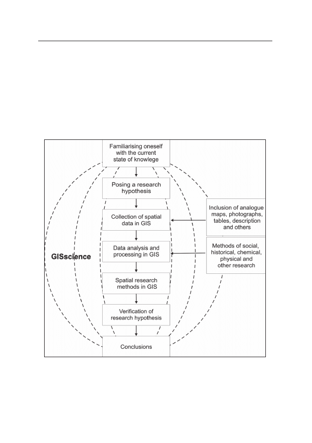
Information System. It can be assumed that the GIS method (Fig-
ure 5.1) should take into account all of the above steps, while other
research methods (such as historical analysis, social research, chem-
ical research etc.) can be a follow up, and not the leading method.
Figure 5.1. Conceptualisation of GIS as a science
Source: I. Jażdżewska and J. Urbański (2013)

5. GIS in the studies of Łódź geographers
135
5.3. GIS in the studies of Łódź geographers
The scientific community of geographers in the University of Łódź
uses GIS for scientific research to a different extent, mainly as a tool
for spatial analyses of the subject of their studies. They include both
socio-economic geographers and physical geographers. The first
work on a doctoral degree, which can be considered as represent-
ative for GIS science was the doctoral thesis of Iwona Jażdżewska
in 1998 entitled
Functional and morphological transformations in
Rzgow village in the light of numerical methods under the direction
of Professor Stanisław Liszewski, fragments of which were pub-
lished in 1999 (Jażdżewska 1999b). Another was the dissertation
by Anna Majchrowska in 2001 entitled
The impact of anthropogenic
environmental changes on the western part of the Lodz province (with
the use of Geographical Information Systems), promoter Tadeusz
Krzemiński (Majchrowska 2002). Ten years later, in 2012 Alexan-
der Szmidt submitted his thesis
The effect of substrate on the surface
and Quaternary sediments in the Łódź province in the light of cho-
sen GIS methods under the direction of Professor Zbigniew Rdzany.
One example of a post-doctoral degree dissertation was the 2008
paper
The transformation of urban settlement network in Poland in
the light of mathematical methods (Jażdżewska 2008). More and
more young students of geographical sciences in Łódź treat GIS as
a universal workshop for posing and verifying hypotheses related to
spatial data. They publish their first works in scientific journals and
seem to be trained in geoinformation.
In order to learn the opinion of researchers in the Łódź centre
concerning the role of GIS in their professional careers, a survey was
sent to them.
4
Only 20 people answered (15% of employees). They
included professors (15%), associate professors (15%), doctors
(60%) and masters (10%). The results have shown, that the first
4
The survey was sent via the Internet, because it is assumed that the sup-
porters of GIS are proficient in using a computer.

Iwona Jażdżewska
136
ones to join the GIS community were the social and economic geog-
raphers, followed a couple of years later by physical geographers.
They were the people employed in the period of 1970–1999, when
GIS was entering Polish science. All subjects were self-taught, some
of them had the opportunity to get acquainted with the possibilities
of using GIS analysis on internships abroad (in such places as Utre-
cht, Paris, Bari, Marseille). They originally performed independent
simple analyses using GIS, now some of them have them made by
third parties. They worked with basic software packages (MapInfo,
IDRISI, CADGIS, Arc Info, Atlas GIS, QGIS, Surfer, Map marker), and
later began using specialised plugins dedicated to such fields as hy-
drology, climatology. Some of these people wrote software for their
own scientific purposes (Fortran, Gras, Matlab).
An analysis of the questionnaires shows that the widespread
interest in GIS was started by the young generation of scientists em-
ployed in the 21
st
century, as 85% of the 70% of respondents who
started using GIS in their research in 2000 were young scientists.
Many of them had the opportunity to learn GIS in college courses,
trainings, received assistance from their colleagues. Some of them
were also self-taught. They are using ARCGIS, MapInfo, IDRISI,
CADGIS, GRASS, QGIS, Workstation, advanced GIS software pack-
ages dedicated to their discipline. The group includes some people
developing their own software (Fortran, Pascal, Matlab), as well as
beginner Python programmers.
At the moment, there are slightly more (50%) social and eco-
nomic geographers than physical geographers (40%) among re-
searchers using GIS, with 10% responding that they represent the
field of geoinformation. When asked “Are you going to develop
your skills in the use of GIS?”, 85% of respondents answered “yes,
of course”, 10% “yes but only in order not to forget what I have
learned”, with one person declaring that they will no longer learn
GIS, as they commission their works to third parties.
What are the scientific problems discussed by the “fans” of GIS
in Łódź? An analysis of their publications indicates that they are
mainly working in the field of socio-economic geography, including:

5. GIS in the studies of Łódź geographers
137
1. Settlement:
• functional and morphological transformations in the sub-
urban area of large cities (Jażdżewska 1999b, c), brownfields and
green areas in the city (Sobczyński and Wosiak 2002), land cover in
the surrounding of motorways (Lechowski 2013);
• functional and spatial transformation in developed areas
(Jażdżewska 1999a, b);
• morphological analysis of plots of land (ownership, size,
shape, degree of coverage) and their distribution (Jażdżewska
1999a);
• disparities in urbanisation (Jażdżewska 2005);
• transformations of urban settlement network in Poland in the
regional scale of one province (Jażdżewska 2001b), region (Jażdżew-
ska 2012a) as in the whole Poland (Jażdżewska 2008, 2012b);
• analysis of sacred space and landscape of the city, (Jażdżew-
ska 2001a, 2007a, 2010a, c, Dmochowska-Dudek and Klima 2012,
Mordwa 2012, Sobczyński 2012);
2. Social geography:
• differentiation of voting behaviour (Sobczyński 2000, Fry-
kowski and Jażdżewska 2006, Dzieciuchowicz and Dmochow ska-
-Dudek 2012). Diversity of socio-economic characteristics in an
agglomeration (Jażdżewska 2002);
• role of mass media in Poland in process of the system’s trans-
formation (Jażdżewska and Rykiel 2002);
• civil activity in the context of economic development
(Jażdżewska and Frykowski 2009);
• spatial conflicts – the NIMBY syndrome (Dmochowska-Dudek
2013);
• crime in the urban area (Mordwa 2011a, b, 2012, 2013a, b);
• purchasing and spatial behaviour of customers in shopping
centres (Rochmińska 2013);
3. Physical geography:
• applications of GIS in hydrology (Bartnik and Jokiel 1999,
2002);
• glacial processes in the development of sculpture of the
southern margin of the Koło basin (Rdzany et al. 2013);

Iwona Jażdżewska
138
• the assessment of the usefulness of automatic determina-
tion of skeletal lines for geomorphological analyses (Jaskulski and
Szmidt 2013b);
• a visualisation of 40-year-old concepts of professor Klatkowa
using GIS methods (Jaskulski and Szmidt 2012);
4. Interdisciplinary, which concerned:
• extraordinary incidents in the road transport infrastructure
of Łódź province, with effects related to the environment of river
valleys, including river waters (Ziułkiewicz 2007);
• determining the changes in the amount of potential flood
losses based on an analysis of the spatial distribution of forms of
floodplains development (Głosińska and Lechowski 2013).
Spatial analyses were and are the domain of geography and
Geographic Information Systems expanded the possibilities of spa-
tial analysis. We can see that Łódź geographers use the following
methods of spatial analysis based on GIS from among the many car-
tographic methods (such as cartograms, cartodiargams etc.):
• the study of changes in land-use structure using K. Doi method
which is a modification of the method of J.C. Weaver (Jażdżewska
1999a, b);
• the use of buffer zones around high speed roads and motor-
ways to study changes within them (Jażdżewska 1999a, b, Lechow-
ski 2013);
• the use of centroids to analyse the distribution of plots in the
suburban area (Jażdżewska 1999a, b) and to analyse the chang-
es the centres of gravity of cities and urban population in Poland
(Jażdżewska 2006a);
• the use of k-means to study urban settlement network. The
relationship between the administrative division and the urban set-
tlement network in Poland. The structure and spatial typology of
crime in Poland (Jażdżewska 2006b, Mordwa 2012);
• the use of taxonomic methods for regionalisation (Jażdżew-
ska 2008, 2010c);
• a presentation of the rank-size Zipf rule in terms of time-
space (Jażdżewska 2007b, 2008);

5. GIS in the studies of Łódź geographers
139
• using non-parametric kernel functions method for the pre-
sentation of changes in population density (Jażdżewska 2012a),
changes in land use around the motorway (Lechowski 2013);
• the use of hexagonal reference fields area of 0.5 ha for the anal-
ysis of potential changes in flood losses (Głosińska and Lechowski
2013);
• the creation of a geodatabase for the GIS analyses (Nalej
2013, Jaskulski and Szmidt 2013a).
Another aspect of the use of scientific experience of the geog-
raphers of Łódź working in GIS were the pages in the Atlas of Łódź
(2002, annexes in 2009, 2012), edited by S. Liszewski, in which
a number of authors from the Faculty of Geographical Sciences
used the geodetic data and their own data for the presentation of
spatial structures of the city, including:
The multinational cultural
heritage of Łódź (Kulesza 2012), The territorial divisions of Łódź
(Jażdżewska and Lechowski 2012),
The road and street network in
Łódź (Jażdżewska and Godula 2012), Voting behaviours of the in-
habitants of Łódź: local elections in 2010 (Dzieciuchowicz and Dmo-
chowska-Dudek 2012).
At the Faculty of Geographical Sciences, University of Łódź,
a team of employees of the Department of Geoinformation team
joined the discipline of
GISience. They initiated (together with prof.
Jacek Urbański of University of Gdańsk) Poland’s first conference
entitled “GIS in science”, whose first edition took place in 2012, and
the subsequent ones will be held at universities all over Poland.
5
It
may become the nucleus for a broader discussion about the role of
GIS science in the research by Polish geographers, as well as of the
development of the discipline in Poland. The activities in teaching
and science has led to the creation of a “Piksel” students’ group,
which allows the students to develop their interest in GIS. Participa-
tion in scientific conferences, work in research teams, collaboration
with practicioners, classes in geography and geoinformation should
5
The 2
nd
GIS in science conference was organised in Lublin, at the Maria
Skłodowska-Curie University, while the third one will take place at the University
of Gdańsk.

Iwona Jażdżewska
140
result in some interesting experiences for the Geoinformation De-
partment team.
The use of Geographical Information Systems among the teach-
ing staff of the Faculty of Geographical Sciences in the first two dec-
ades of the 21
st
century has grown. This allows us to hope that the
subsequent years will bring a huge increase in the number of scien-
tific publications significantly using GIS.
In order to learn the attitudes towards GIS, the survey asked
if GIS is just a tool used in reaserch. The answers were split in half.
Half of the respondents replied positively, but at the same time most
of them declared that they think about using GIS in their research
when starting studies and posing hypotheses, as well as follow sci-
entific publications that utilise GIS. Interestingly, all respondents
who perceive GIS as merely a tool also believe that they are not
among the researchers who can be included in GIScience, with one-
third of them not seeing a future for such discipline.
The second group (50% of respondents) are “enthusiasts” of
GIS, who do not perceive GIS as just a toll, use it at every stage of
their research and think that GIScience has a future, even though
not all of them include themselves in GIScience.
One of the questions was: Do you think about using GIS when
starting a scientific study or posing hypotheses? As many as 90%
of respondents answered this question positively, 80% of them
check the scientific literature for possible uses of GIS in research
in their field, and 90% think that GIScience has a future. Half of the
respondents include the acronym GIS or other word associated with
GIS (such as software tool) in their keywords, which means that an
academic community of GIS users is starting to forming in Łódź.
References
Bartnik A., Jokiel P., 1999,
Wykorzystanie grafiki komputerowej do pre-
zentacji i oceny warunków obiegu wody w małej zlewni w strefie pod-
miejskiej Łodzi. (In:) XI Ogólnopolska Konferencja Naukowa, Łódź,

5. GIS in the studies of Łódź geographers
141
17–19.11.1999, Chemizm opadów atmosferycznych wód powierzchnio-
wych i podziemnych, Wyd. UŁ, Łódź, pp. 30–32.
Bartnik A., Jokiel P., 2002,
Metody badań i sposoby prezentacji wyników.
(In:) Jokiel P. (ed.),
Woda na zapleczu wielkiego miasta, ZHiGW UŁ,
Łódź, pp. 11–22.
Dmochowska-Dudek K., 2013,
Syndrom NIMBY w przestrzeni wielkomiej-
skiej. Przykład Łodzi, Wyd. UŁ, Łódź.
Dmochowska-Dudek K., Klima E., 2012,
Metody analizy krajobrazu sakral-
nego miasta. (In:) Bernat S., Flaga M. (eds.), Sacrum w krajobrazie, Pra-
ce Kom. Krajobr. Kult., Sosnowiec, pp. 171–183.
Dzieciuchowicz J., Dmochowska-Dudek K., 2012,
Postawy wyborcze miesz-
kańców Łodzi: wybory samorządowe w roku 2010, Plansza XIX b. (In:)
Liszewski S. (ed.),
Atlas miasta Łodzi, Urząd Miasta, Łódź.
Fiejdasz W., Widacki W. (eds.), 1995,
GIS dla obszarów chronionych, Inst.
Geogr. UJ, Kraków.
Frykowski M., Jażdżewska I., 2006,
Samoobrona a kapitał społeczny gmin
wiejskich, Studia Wybor., 1, pp. 111–130.
Gaździcki J., 1990,
Systemy informacji przestrzennej, PPWK, Warszawa–
Wrocław.
Głosińska E., Lechowski Ł., 2013,
An estimation of potential flood losses in
the context of floodplain development changes using GIS, Acta Univ.
Lodz., Folia Geogr. Socio-Oecon., 14, pp. 117–132.
Goodchild M., 2010,
Twenty years of progress: GIScience in 2010, J. Spat.
Info. Sci., 1, pp. 3–20.
Hencz I. (now I. Jażdżewska), 1995,
Mapa numeryczna terenu. Materiały
z konferencji „Zadania badawcze geografii społecznej i ekonomicznej
w obliczu transformacji ustrojowej”, UWr., Wrocław–Szklarska Poręba,
pp. 121–125.
Jaskulski M., Szmidt A., 2012,
Północne przedpole Wyżyny Łódzkiej koncep-
cja prof. H. Klatkowej w świetle badań GIS. (In:) Dzieduszyńska D., Ro-
man M. (eds.),
Czynniki różnicowania rzeźby niżu Polskiego, Uniejów,
pp. 35–37.
Jaskulski M., Szmidt A., 2013a,
Geobaza obiektów znajdujących się na liście
światowego dziedzictwa UNESCO. (In:) Materiały Konferencji GIS w Na-
uce, Lublin.
Jaskulski M., Szmidt A., 2013b,
Ocena przydatności automatycznego wyzna-
czania linii szkieletowych terenu dla analiz geomorfologicznych, Acta
Univ. Lodz., Folia Geogr. Socio-Oecon., 14, pp. 145–156.

Iwona Jażdżewska
142
Jażdżewska I., 1999a,
Les transformationes funcionales y morfologogocas
efectuades en los suburbios do Łódź – ejemplo de Rzgow. (In:) Czer-
ny M., Makowski J. (eds.),
Aanalisis territorial de las cambios socioeco-
nomocos y medioambientales de las grandes ciudades en las dos ultimas
decadeas del siglo XX, UW, Warszawa.
Jażdżewska I., 1999b
, Przemiany funkcjonalne i morfologiczne przestrzeni
geograficznej wsi Rzgów w świetle metod numerycznych, ŁTN, Łódź.
Jażdżewska I., 1999c,
Zastosowanie numerycznej bazy adresowej w geo-
grafii społecznej. (In:) Kaczmarek J. (ed.), XI Konwersatorium Wiedzy
o Mieście, Łódź, pp.97–103.
Jażdżewska I., 2001a,
Administrative changes in the Catholic church in Cen-
tral and Eastern Europe. (In:) Wendt J., Ilies A. (eds.), Chosen Problems
of Political Geography in Central Europe, Wyd. UG, Gdańsk, pp. 5–14.
Jażdżewska I., 2001b
, Miejska sieć osadnicza i jej przemiany. (In:) Liszew-
ski S. (ed.),
Zarys monografii województwa łódzkiego, ŁTN, Łódź,
pp. 225–240.
Jażdżewska I., 2002,
Zróżnicowanie cech społeczno-ekonomicznych aglo-
meracji łódzkiej w 2000. (In:) Jażdżewska I. (ed.), Współczesne formy
osadnictwa miejskiego i ich przemiany. XV Konwersatorium Wiedzy
o Mieście, ŁTN, Łódź, pp. 99–108.
Jażdżewska I., 2005,
Zróżnicowanie poziomu urbanizacji w Europie. (In:)
Jażdżewska I. (ed.),
Współczesne procesy urbanizacji i ich skutki.
XVIII Konwersatorium Wiedzy o Mieście, Wyd. UŁ, Łódź, pp. 173–182.
Jażdżewska I., 2006a,
Zmiana położenia środka ciężkości miast i ludności
miejskiej w Polsce w XX w., Przegl. Geogr., 78 (4), pp. 561–574.
Jażdżewska I., 2006b,
Związek między podziałem administracyjnym a miej-
ska siecią osadniczą Polski. Zastosowanie metody k-średnich do badań
miejskiej sieci osadniczej, Przegl. Geogr., 78 (2), pp. 247–259.
Jażdżewska I., 2007a,
Changes in the sacral space in the post-communist
cities. (In:) Kamińska W., Mularczyk M. (eds.), Cities of the World – Se-
lected Issues, Prace Inst. Geogr. Akad. Świętokrzyskiej, 15, pp. 85–94.
Jażdżewska I., 2007b,
Rola małych miast w miejskiej sieci osadniczej Pol-
ski. (In:) Rydz E. (ed.), Podstawy i perspektywy rozwoju małych miast,
Akad. Pomorska, Słupsk, pp. 31–46.
Jażdżewska I., 2008,
Przemiany miejskiej sieci osadniczej w Polsce w świetle
metod matematycznych, Wyd. UŁ, Łódź.
Jażdżewska I., 2010a,
Rzeki bariery w kształtowaniu się miejskiej sieci osad-
niczej Polski w świetle zastosowań Systemów Informacji Geograficznej.

5. GIS in the studies of Łódź geographers
143
(In:) Kaczmarek S. (ed.),
Księga jubileuszowa w 70. Rocznicę urodzin
Profesora Stanisława Liszewskego, Miasto, Wyd. UŁ, Łódź, pp. 155–177.
Jażdżewska I., 2010b,
Sakralizacja osiedli blokowych. Przykład Łodzi i Sankt
Petersburga. (In:) Jażdżewska I. (ed.), Osiedla blokowe w strukturze
przestrzennej miast. XXIII Konwersatorium Wiedzy o Mieście, Wyd. UŁ,
Łódź, pp. 151–170.
Jażdżewska I., 2010c,
Zastosowanie Systemów Informacji Geograficznej
(SIG) w badaniach geograficznych. (In:) Liszewski S. (ed.), Obszary me-
tropolitalne we współczesnym środowisku geograficznym, PTG, Wydz.
Nauk Geogr. UŁ, Łódź, pp. 203–216.
Jażdżewska I., 2012a,
Changes of the urban population density in Central
Poland. (In:) Population Density Distribution Estimation Using Nonpa-
rametric Kernel Functions, Człow. i Środ., 36 (3), pp. 7–19.
Jażdżewska I., 2012b,
Kształtowanie się metropolii w Polsce w świetle zmian
gęstości ludności miejskiej, Acta Univ. Nic. Copern., Ekonomia, 43, Nau-
ki Hum.-Społ.
Jażdżewska I., Frykowski M., 2009,
Rozwój społeczny gmin a aktywność
obywatelska mieszkańców wsi i małych miast województwa łódzkiego.
(In:) Psyk-Piotrowska E. (ed.),
Kapitał społeczny. Partycypacja obywa-
telska. Rozwój lokalny, Wyd. UŁ, Łódź, pp. 104–128.
Jażdżewska I., Godula E., 2012,
Sieć drogowo-uliczna Łodzi, Plansza LXIV.
(In:) Liszewski S. (ed.),
Atlas miasta Łodzi, Urząd Miasta, Łódź.
Jażdżewska I., Lechowski Ł., 2012,
Podziały terytorialne Łodzi Plansza XXIVa.
(In:) Liszewski S. (ed.),
Atlas miasta Łodzi, Urząd Miasta, Łódź.
Jażdżewska I., Rykiel. Z., 2002,
The role and extension of mass media in Po-
land in process of the system’s transformation. (In:) Horga I., de la Bros-
se R. (eds.),
The Role of Mass-Media and the New Information and
Communication Technologies in the Democratization Process of the
Central and Eastern European Societies, Intern. Inst. of Admin. Stud.,
Bruksela, pp. 216–222.
Jażdżewska I., Urbański J., 2013,
GIS w nauce, Acta Univ. Lodz., Folia Geogr.
Socio-Oecon., 14, pp. 5–15.
Kistowski M., 1993,
Cyfrowe bazy informacji geograficznych, Ekobałtyk, 11,
pp. 22–23.
Kistowski M., 2001,
Systemy informacji geograficznej – niechciane dziecko
czy nadzieja dla geografii polskiej? Geografia a GIS w Polsce w latach
1990–1999, Przegl. Geogr., 73 (1–2), pp. 143–162.

Iwona Jażdżewska
144
Kozak J., 1997,
Wprowadzenie do systemów informacji geograficznej – ćwi-
czenia, Inst. Geogr. UJ, Kraków.
Kulesza M., 2012,
Wielonarodowe dziedzictwo kulturowe Łodzi. Plansza
LXXII. (In:) Liszewski S. (ed.), Atlas miasta Łodzi, Urząd Miasta, Łódź.
Lechowski Ł., 2013,
Analiza zmian pokrycia terenu wokół autostrad za
pomocą metod GIS, Acta Univ. Lodz., Folia Geogr. Socio-Oecon., 14,
pp. 59–75.
Liszewski S. (ed.), 2002, 2009, 2012,
Atlas miasta Łodzi, Urząd Miasta, Łódź.
Magnuszewski A., 1999,
GIS w geografii fizycznej, WN PWN, Warszawa.
Majchrowska A., 2002,
Wpływ antropopresji na przemiany środowiska przy-
rodniczego zachodniej części województwa łódzkiego (z wykorzysta-
niem Systemów Informacji Geograficznej), Acta Geogr. Lodz., 82.
Mordwa S., 2011a,
Kradzieże w przestrzeni Łodzi, Acta Univ. Lodz. Folia
Geogr. Socio-Oecon., 11, pp. 187–206.
Mordwa S., 2011b,
Przestępstwa w przestrzeni publicznej. Przykład Łodzi.
(In:) Jażdżewska I. (ed.), C
złowiek w przestrzeni publicznej miasta,
Łódź, pp. 231–240.
Mordwa S., 2012,
Struktura i typologia przestrzenna przestępczości w Pol-
sce – przykład wykorzystania walidacji liczby skupień w metodzie
k-średnich, Acta Univ. Lodz., Folia Geogr. Socio-Oecon., 12, pp. 89–110.
Mordwa S., 2013a,
Przestępczość i poczucie bezpieczeństwa w przestrzeni
miasta. Przykład Łodzi, Wyd. UŁ, Łódź.
Mordwa S., 2013b,
Zastosowanie GIS w badaniach przestępczości, Acta Univ.
Lodz., Folia Geogr. Socio-Oecon., 14, pp. 77–92.
Nalej M., 2013,
Geobaza obiektów hotelarskich w Łodzi. (In:) Materiały Kon-
ferencji GIS Nauce, Lublin.
Paszczyk J., Wiśniewski M., Wlaź P., 1994,
System gromadzenia numerycz-
nej informacji o terenie – NIT, Ann. UMCS, B, 49 (25), pp. 355–363.
Rdzany Z., Szmidt A., Tarnawska K., 2013,
Rola procesów glacjalnych
w kształtowaniu rzeźby południowego obrzeżenia Kotliny Kolskiej, Biul.
Uniejowski, 2, pp. 5–22.
Rochmińska A., 2013,
Atrakcyjność łódzkich centrów handlowych oraz za-
chowania nabywcze i przestrzenne ich klientów,Wyd. UŁ, Łódź.
Sobczyński M., 2000,
Zróżnicowanie przestrzenne postaw politycznych
mieszkańców Łodzi, Wyd. UŁ, Łódź.
Sobczyński M., 2012,
Świątynie w wielokulturowej przestrzeni Łodzi. (In:)
Krawiec-Złotkowska K. (ed.),
Rzeczpospolita domów. Domy Boże, t. 3,
Akad. Pomorska, Słupsk, pp. 602–625.

5. GIS in the studies of Łódź geographers
145
Sobczyński M., Wosiak A., 2002,
Ugory miejskie, tereny zielone oraz inwesty-
cje z ostatniej dekady XX w. w strukturze użytkowania ziemi dzielnicy
pomocniczej Katedralna w Śródmieściu Łodzi. (In:) Jażdżewska I. (ed.),
Współczesne formy osadnictwa miejskiego i ich przemiany. XV Konwer-
satorium Wiedzy o Mieście, Łódź, pp. 79–90.
Urbański J., 1997,
Zrozumieć GIS, PWN, Warszawa.
Werner P., 1992,
Wprowadzenie do geograficznych systemów informacyj-
nych, UW, Warszawa.
Werner P., Prokop P., 1999,
Zastosowania systemów informacji geograficz-
nej w geografii polskiej. (In:) Domański B., Widacki W. (eds.), Geogra-
fia polska u progu trzeciego tysiąclecia, t. 4, Inst. Geogr. UJ, Kraków,
pp. 275–291.
Widacki W., 1997,
Wprowadzenie do systemów informacji geograficznej,
Inst. Geogr. UJ, Kraków.
Wright D.J., Goodchild M.F., Proctor J.D., 1997,
Demystifying the persistent
ambiguity of GIS as ‘tool’ versus ‘science’, Ann. Assoc. Am. Geogr.,
87 (2), pp. 346–362.
Ziułkiewicz M., 2007,
Nadzwyczajne zdarzenia w infrastrukturze transpor-
tu drogowego województwa łódzkiego, Acta Univ. Lodz., Folia Geogr.
Physica, 8, pp. 151–163.
Wyszukiwarka
Podobne podstrony:
Jażdżewska, Iwona The Warsaw – Lodz Duopolis in the light of the changes in the urban population de
Sobczyński, Marek Achievements of the Department of Political Geography and Regional Studies, Unive
Studies in the Psychology of Sex, Volume 1 by Havelock Ellis
Studies in the Psychology of Sex, Volume 5 by Havelock Ellis
Studies in the Psychology of Sex, Volume 3 by Havelock Ellis
Baranowska, Magdalena; Kulesza, Mariusz The role of national minorities in the economic growth of t
Studies in the Psychology of Sex, Volume 2 by Havelock Ellis
Studies in the Psychology of Sex, Volume 4 by Havelock Ellis
CIA s Role in the Study of UFOs 1947 90 by Gerald K Haines Studies In Intelligence v01 №1 (1997)
Sosnowska, Joanna Care for the disabled and the ill in the activities of Łódzkie Chrześcijańskie To
In the Wake of Cultural Studies Globalization,Theory and the University Rajan, Tilottama
The History of the USA 6 Importand Document in the Hisory of the USA (unit 8)
Civil Society and Political Theory in the Work of Luhmann
Sinners in the Hands of an Angry GodSummary
Capability of high pressure cooling in the turning of surface hardened piston rods
Formation of heartwood substances in the stemwood of Robinia
54 767 780 Numerical Models and Their Validity in the Prediction of Heat Checking in Die
No Man's land Gender bias and social constructivism in the diagnosis of borderline personality disor
więcej podobnych podstron