
I:\MSC\76\INF-4.doc
For reasons of economy, this document is printed in a limited number. Delegates are
kindly asked to bring their copies to meetings and not to request additional copies.
INTERNATIONAL MARITIME ORGANIZATION
IMO
E
MARITIME SAFETY COMMITTEE
76th session
Agenda item 11
MSC 76/INF.4
19 August 2002
ENGLISH ONLY
SAFETY OF NAVIGATION
Report of the forty-eighth session of the Sub-Committee
World-Wide Radionavigation System
Presentation of the GALILEO Services and Architecture
Submitted by the European Commission
SUMMARY
Executive summary:
This document is aimed to inform the Committee of the GALILEO
Services and Architecture Document detailing the current baseline of
the GALILEO satellite navigation system under development by the
European Commission and the European Space Agency
Action to be taken:
Paragraph 3
Related documents:
Resolutions A.815(19) and A.915(22); Report of the forty-eighth
NAV Sub-committee
INTRODUCTION
1
The two resolutions; A.815(19) and A.915(22), form the backbone of IMO’s
requirements for future Maritime Radionavigation Systems. A.815(19) gives the formal
requirements and procedures for accepting new systems as ‘components of the World-Wide
Radionavigation System (WWRNS)’, while A.915(22) sets the requirements for future
developments of GNSS to be considered within the framework of A.815(19).
Both the Global Positioning System (GPS-SPS) and GLONASS were recognised as possible
components of the WWRNS by the MSC, based on the recommendations and assessments made
by the Sub-committee on Safety of Navigation.
The procedures for the recognition of the GALILEO navigation services as well as adoption of
standards for GALILEO receiver equipment, is anticipated to be similar as for the GPS and
GLONASS systems.
It is the aim to establish GALILEO as part of the WWRNS.

MSC 76/INF.4
- 2 -
I:\MSC\76\INF-4.doc
The forty-eighth session of the Navigation sub-committee has introduced GALILEO as a work
item on the agenda for the forty-ninth session of the NAV Sub-Committee.
Therefore it is felt that early interaction between the GALILEO program and IMO will be most
helpful to simultaneously inform IMO of all relevant GALILEO characteristics and collect
feedback from IMO on main system features and user requirements. Such interaction is foreseen
for both Navigation and Search And Rescue aspects.
Galileo will be the European contribution to the Global Navigation Satellite System (GNSS).
Galileo is a global infrastructure comprising a constellation of satellites in Medium Earth Orbit
(MEO) and its associated ground segment. The Galileo Programme also includes the
development of user equipment, applications and services. Galileo is designed to be interoperable
with other existing global radio-navigation systems. It is a civil system, operated under public
control.
The Galileo Programme is at present jointly managed and financed by the EC and ESA under a
mandate from their Member States. GALILEO shall enter into full operation in 2008.
GALILEO Services and Architecture
2
The attached document details the current status of the GALILEO services and
Architecture as proposed by the European Commission and ESA. The GALILEO services are
proposed to the Council of the European Community for adoption. The attached document
should be considered as a living document that may adapt to changing user needs.
Following the preparatory activities of previous years, the Galileo Definition Phase was
undertaken by EC and ESA during the year 2000. This led to the European Commission
Communication on Galileo in November 2000, the ESA Council Resolution in December 2000
and to the Council of the European Community decision of April 2001.
Based on the Definition Phase, a first Galileo Mission High Level Definition (April 2001) was
written and consolidated through a consultation process involving Member States, user
communities and potential private investors.
In June 2001, new studies were incepted by ESA and EC consolidating the Definition Phase and
paving the way for preparing the launch of the Development and Validation Phase. ESA B2
Phase study (the Galileo system architectural study) started in June 2001 and EC started the
Galilei study in August 2001, which comprises of a set of complementary studies to B2 Phase
Study, covering aspects such as the local components, frequency issues, interoperability issues,
legal issues, and detailed market analysis.
Specific User Fora and consultations have been organised in 2002 in order to ensure that the
updated services definition covers the user needs properly. This consultation process has allowed
the feedback from different user communities to be taken into consideration.
The outcome of all the above-mentioned activities have assisted in the consolidation of the
Galileo services and architecture.
Action requested of the Committee
3
The Committee is invited to take note the information provided above and in the attached
GALILEO Services and Architecture document.

GALILEO Services and Architecture
1
Services and Architecture

GALILEO Services and Architecture
2
Table of Contents
1 Introduction ...................................................................................................................................3
1.1 The European Satellite Navigation Strategy ........................................................................................ 3
1.2 Socio-economic
aspects........................................................................................................................ 4
1.3 Interoperability ..................................................................................................................................... 5
1.4 Certification and standardisation.......................................................................................................... 5
1.4.1 Certification ................................................................................................................................................ 5
1.4.2 Standardisation............................................................................................................................................ 6
1.5 Service
Guarantees ............................................................................................................................... 6
1.6 International
co-operation .................................................................................................................... 7
2 Galileo
Services.............................................................................................................................8
2.1 Galileo satellite-only services............................................................................................................... 8
2.1.1 Open
Service............................................................................................................................................... 9
2.1.2 Commercial
Service.................................................................................................................................. 10
2.1.3
Safety of Life Service ............................................................................................................................... 10
2.1.4 Public
Regulated Service .......................................................................................................................... 12
2.1.5
Galileo support to the Search and Rescue Service.................................................................................... 13
2.2 Locally assisted services..................................................................................................................... 14
2.3 EGNOS
Services ................................................................................................................................ 16
2.4 Combined
services ............................................................................................................................. 17
2.4.1
Services resulting from combination of Galileo with other GNSS systems ............................................. 17
2.4.2
Services resulting from Galileo with non-GNSS systems ........................................................................ 18
3 Galileo
System ............................................................................................................................21
3.1 Global
component .............................................................................................................................. 22
3.1.1 Space
segment........................................................................................................................................... 22
3.1.2
Signal in Space (SIS) ................................................................................................................................ 23
3.1.3 Ground
segment........................................................................................................................................ 25
3.2 Local
components............................................................................................................................... 25
3.3 EGNOS............................................................................................................................................... 27
3.4 User
segment ...................................................................................................................................... 27
3.5 External Galileo-related system components ..................................................................................... 28
3.5.1 Non-European
Regional Components ...................................................................................................... 28
3.5.2 Search
and
Rescue systems....................................................................................................................... 29
4 Development
Plan .......................................................................................................................31
5 Organisation of the programme...................................................................................................32
5.1 Overall organisation during Development and Validation Phase....................................................... 32
5.2 Management Structure during Development and Validation Phase................................................... 33
Annex 1: Acronyms and abbreviations..............................................................................................34
Annex 2: Signals, Frequencies and mapping into services................................................................36
Annex 3: EGNOS Coverage Area and Performance .........................................................................43
Annex 4: Definitions..........................................................................................................................45

GALILEO Services and Architecture
3
1 Introduction
Galileo will be the European contribution to the Global Navigation Satellite System (GNSS).
Galileo is a global infrastructure comprising a constellation of satellites in Medium Earth Orbit
(MEO) and its associated ground segment. The Galileo Programme also includes the development
of user equipment, applications and services. Galileo is designed to be interoperable with other
existing global radio-navigation systems. It is a civil system, operated under public control.
The Galileo Programme is at present jointly managed and financed by the EC and ESA under a
mandate from their Member States.
1.1 The European Satellite Navigation Strategy
As a result of the quality of service offered, satellite navigation is now set to become the primary
means of navigation for most of civil applications, world-wide. Satellite navigation, positioning and
timing have already found widespread application in a large variety of fields and will be an integral
part of the Trans European Network
1
. Many safety-critical services, in areas of transport and
numerous commercial applications will depend on this infrastructure.
The European Commission White Book on transport policy has highlighted the importance of
decoupling economic growth and transport needs: this will be achieved by shifting the balance of
transport modes, the elimination of bottlenecks and by placing users at the heart of transport policy.
Galileo has been highlighted as a promising instrument to reach these goals.
Existing terrestrial Radio Navigation aids are widespread in number and technology all over
Europe. Different types of systems are used by each transport community but without a co-
ordinated policy at the European level. A potential ERNP (European Radio-Navigation Plan) is
under elaboration to encourage a common European approach to radio navigation, positioning and
timing means across all modes of transport. Aviation and maritime communities are already well
organised on a global level in this respect but other communities support various national standards.
In this context, Satellite Navigation is a key element of the ERNP because of its multimodal and
supranational character.
One major concern for the current Satellite Navigation users is the reliability and vulnerability of
the navigation signal. Several cases of Satellite Navigation service disruption have been reported
over the past years, which have had many different origins, including unintentional interference,
satellite failure, signal denial or degradation. In this context, Galileo will contribute significantly to
reduce these shortcomings by providing independently additional navigation signals broadcast in
different bands.
Recognising the strategic importance of satellite navigation, its potential applications and the
current GNSS systems shortcomings, Europe decided to develop its own GNSS capability in a
two-step approach:
• EGNOS (European Geostationary Navigation Overlay Service) is the first European step in
satellite navigation that will be operational by 2004. Europe is building EGNOS as a
complement to GPS and the Russian GLONASS (GLObal NAvigation Satellite System) to
provide a civil service. EGNOS implements a warning of system malfunction (integrity) of
the GPS and GLONASS constellations. The provision of this quality control service is
essential for safety critical applications. EGNOS will also improve the accuracy of GPS and
1
TEN guidelines Decision Council /EP 1996

GALILEO Services and Architecture
4
GLONASS by means of differential corrections. Similar initiatives are being developed in
US (WAAS system) and Japan (MSAS system). The ICAO (International Civil Aviation
Organization) international SBAS (Satellite Based Augmentation System) standards
guarantee the interoperability of all these systems at user level. Besides its own specific
operational objective as the European SBAS, EGNOS is a unique instrument to gain
experience not only in the development of GNSS technology but also, most importantly, in
the operational introduction of Galileo services.
• Galileo is the second step. EGNOS provides Europe with early benefits but does not provide
Europe with a sufficient level of control over GNSS. The introduction of satellite navigation
services on a very large scale and the implementation of European regulations cannot be
envisaged if users become fully dependant on a single system, outside European control.
Galileo represents the European objective of autonomy for such a strategic and crucial
technology. It will provide the required stability for European investments in this area and
elevate European industries in innovative market segments. Galileo will also offer,
alongside an open service similar to the GPS civilian service, new features to improve and
guarantee services, thereby creating the conditions for responding to obligations imposed by
critical, safety of life, or commercial applications. Galileo services are required to be fully
compatible and interoperable at user level with other GNSS services, with no common
failure mode between systems. This combined use of Galileo and other GNSS systems will
offer better performances for all kinds of user communities all over the world.
This strategy is reflected in the EC communications on Galileo
2
3
, and in the Galileo resolution of
the Council of the European Union
4
. The latter adopted the resolution, highlighting the objective of
European autonomy for such a strategic and crucial technology for the benefit of our society and
economy. ESA Member States agreed on an integrated strategic vision for the provision of
European GNSS Services by the combined use of EGNOS and Galileo services
5
.
ESA Member States adopted the GalileoSat programme
6
declaration at Council level (Edinburgh
November 2001) and in the Council of Heads of States and Governments of the EU (Barcelona,
13-14 march 2002) gave the political support to Galileo. The Council of the European Union
(Brussels, 26 March 2002) gave financial support to the Galileo programme and approved the
establishment of a Joint Undertaking for the management of the programme.
1.2 Socio-economic aspects
Previous studies, including GALA, Geminus, Galileo Cost-Benefit Analysis and the Business Plan
for the Galileo Programme, have analysed future market prospects and identified potential sources
of revenue. The economic aspects are a key driver of the Galileo programme and the mission
consolidation activities should be steered by these elements. Only with this approach will Europe
have a self-sustainable system that will bring important social and user benefits and have a
significant effect on the European economy.
2
Commission Communication, “Galileo, Involving Europe in a New Generation of Satellite Navigation Services”,
COM (1999) 54 final, 10.02.1999
3
Commission Communication on “Galileo”, COM (2000) 750 final, 22.11.2000
4
Council Resolution on Galileo, 7918/01, 5.04.2001
5
ESA/PB-NAV(2001)29, rev.1
6
ESA/C (2001)117

GALILEO Services and Architecture
5
1.3 Interoperability
Galileo is being designed as an independent system but at the same time, this design is optimised
for use with other systems, notably GPS.
Key drivers for facilitating the use of Galileo with other systems are user requirements and the
object of gaining access to future GNSS market. The main reasons are:
• Satellite navigation systems present some technical constraints (e.g. low power signals),
which prevent them from meeting the overall identified user requirements, especially the
most demanding.
• The late arrival of Galileo in the future satellite navigation market dominated by GPS
applications.
Consequently, three main interoperability objectives have been identified. They are to:
• Facilitate interoperability of Galileo with other GNSS systems (most notably GPS) at
receiver level. This is reflected in the study and choice of:
a) Galileo frequencies.
b) Signal structure.
c) Time reference frame.
d) Geodetic datum.
• Assess the combined use of Galileo with other non-GNSS systems, such as ground
navigation systems or mobile communication networks, to enable a reduction of GNSS
deficiencies through the provision of combined positioning services. Potential issues to be
studied at user level are similar to those mentioned for GNSS systems;
• Facilitate the use of Galileo with telecommunication systems to provide jointly
navigation/communication services. This is an additional functionality that:
a) enables enhanced communications capabilities (e.g. higher data transfer)
b) facilitates the generation of GNSS value-added services, such as location based
services, with a strong influence in the future GNSS market.
The combined use of Galileo with all these systems will introduce interoperability requirements not
only in the Galileo global components but also in the design of local components and user
equipment.
• Studies on these issues are currently performed in the Signal Task Force and ESA/EC
contracts. Significant results are expected by the end of 2002.
1.4 Certification and standardisation
1.4.1 Certification
Certification is a process by which a mandated body will independently assess the compliance of
the system with standards identified by a regulating authority. This standardisation process, mainly
focusing on the signals and/or services delivered by Galileo, will not overlap or replace traditional
certification schemes used by different user communities to certify specific applications. On the
contrary, it is perceived as a pre-requisite whereby user communities, such as aviation or maritime,
can build their own safety analysis taking into account their particular specifications in terms of
environment and user equipment.
The certification scheme that will be built for Galileo will cover the whole life cycle of the system
including system design, implementation and operation phases during which quality assurance shall
be provided.

GALILEO Services and Architecture
6
A certification mechanism will be proposed to Member States that involves all main actors of the
Galileo project including users, regulators, system designer and service operator/providers.
The Galileo system will be designed, built and operated to perform to very high performance
standards and, as mentioned above, it is the intent that a form of guarantee can be offered to user
communities with special interest in such a feature. In this framework, the certification of the
system will increase user confidence in the performance delivered by the system and will set the
basis for a guarantee scheme.
1.4.2 Standardisation
The introduction of an ambitious system such as Galileo that will offer a world-wide service to
many different kinds of users requires significant activity in the standardisation domain.
Europe is already very active regarding the standardisation of Galileo and will maintain a pro-active
attitude to support the development of standards having regard to the motivations of different user
communities (safety, interoperability, commercial considerations).
The work undertaken will be pursued to identify the actors involved and set-up specific action plans
to support the development of standards on a case-by-case basis. In general, the schemes are quite
complex with numerous levels of responsibilities, sometimes overlapping, and that very often
involve international co-operation with some level of political interest. Actions have already been
launched in the aeronautical and maritime domains that benefit from the very clearly identified
standardisation frameworks in ICAO and IMO. Work is on going within the rail and road
communities to satisfy their specific standardisation needs. Finally, other communities, likely to use
Galileo, such as cellular phone operators and location-based service providers in general are also
starting to participate in the development of standards contributing to the promotion of Galileo.
Globally recognised signal and user receiver standards will be essential for the world-wide
acceptance of satellite navigation and will permit a faster adoption of the system by all user
communities.
1.5 Service Guarantees
The Galileo services result from the processing of a combination of signals, by the user terminal,
under certain nominal environmental conditions (no intentional interference, low multi-path….).
It is envisaged that a guarantee will be offered for all applications for which a disruption of service
would have significant Safety of Life or economic impacts. This guarantee is a major differentiator
between Galileo and GPS.
The Joint Undertaking, as mentioned in section 6.1, will proactively undertake discussions with the
appropriate regulatory bodies to initiate the certification
7
process concerning both the Galileo-
Signal-in-Space and user terminals.
The Galileo Operating Company (GOC) will commit to provide the quality of the Signal In Space
to achieve the specified service at end-user level. An agreement or contract will be concluded
between the Operator and the users or, in certain cases with third party Service providers, in which
the quality of the Signal In Space will be guaranteed by the GOC with certain specifications defined
in the Interface Control Document. In case the Signal In Space (SIS) fails to meet certain margins of
accuracy, the GOC will provide timely warnings to users.
7
The general understanding is that the term certification applies to safety of life terminals, whereas commercial
terminals would be ‘type approved' through a procedure jointly agreed, between the operator and the users.

GALILEO Services and Architecture
7
The system will record the status of the Signals In Space (SIS). Should the SIS fall below specified
standards, the records can be investigated to assist in finding the cause of the problem.
Compensation may be payable to Galileo users if loss can be proved through use of the signal, but,
perhaps also if the performances guaranteed fall short of those stipulated.
Practical modalities for the implementation of the above-defined guarantees will be further
investigated during the development phase.
In the case of the open service, which will be accessible by users without any control from the
Galileo Operating Company, no contractual guarantee is foreseen. Since this service will be used
for mass-market applications, the Galileo Operating Company will endeavour to avoid service
disruption and will provide the open signals with nominal performances.
1.6 International co-operation
The Galileo system will provide an autonomous European satellite navigation capability that will
co-exist with already implemented core constellations or augmentations. In this context, the
European Union is open to international co-operation. In particular, it is intended that bilateral co-
operation be established with international GNSS service providers to optimise system
interoperability.
Similarly, the Galileo design will offer a capability for deployment of regional integrity monitoring
networks. International co-operation will be pursued to identify partners likely to be interested in
this feature.
Finally, the Galileo services will be offered world-wide and dialogue has been established early
with the international community through different standardisation organisations to collect feedback
on major system characteristics. Such interaction will continue throughout the lifetime of the
programme.

GALILEO Services and Architecture
8
2 Galileo Services
The definition of the Galileo services is based on a comprehensive review of user needs and market
analysis. There will be some services provided autonomously by Galileo and other services
resulting from the combined use of Galileo and other systems. This leads to the classification of the
Galileo services into four categories:
1) Galileo satellite-only services
These services will be provided worldwide and independently from other systems by combining the
signals broadcast by the Galileo satellite. There is a wide range of possible applications with
different operational requirements that have been grouped around the following five reference
services:
!
Galileo Open Service (OS)
!
Safety of Life (SoL).
!
Commercial service (CS).
!
Public regulated Service (PRS).
!
Support to Search and Rescue service (SAR).
2) Galileo locally assisted services
The Galileo satellite-only services can be enhanced on a local basis through a combination of local
elements. The result will be the provision of local services.
3) EGNOS services
EGNOS will provide over Europe an augmentation to GPS and GLONASS services from 2004
onwards. This service will allow for early experience in development of Galileo-like applications.
The EGNOS services will be combined with the Galileo satellite-only services. This will allow
higher performance levels to be met by using different sources of integrity and navigation
information.
4) Galileo combined services
All the above-mentioned services will in most instances be combined with services provided by
other navigation or communication systems. This possibility will improve the GNSS services
availability at user level and open the door to a wide range of applications. The result will be the
provision of combined services.
2.1 Galileo satellite-only services
The Galileo services can be referred back to the latest publicised and accepted realisation of the
international terrestrial reference frame (ITRF) and the universal time coordinate (UTC). This is
important for interoperability with other GNSS, most notably GPS.
The Galileo satellite-only service performances are expressed at user level. All performance
statistics include the contribution of the receiver (noises, failures, etc).
Users equipped with Galileo receivers (or having Galileo functionality in their terminals)
conforming to minimum operational requirements shall be able to achieve the specified
performance under nominal conditions with no intentional jamming, no exceptional interference, no
exceptional ionospheric or tropospheric activity, a masking angle of 10° and low multipath
environment.
GALILEO Services and Architecture
9
2.1.1 Open Service
Purpose
The Galileo Open Service provides positioning, velocity and timing information that can be
accessed free of direct charge. This service is suitable for mass-market applications, such as in-car
navigation and hybridisation with mobile telephones. The timing service is synchronised with UTC
when used with receivers in fixed locations. This timing service can be used for applications such as
network synchronisation or scientific applications.
Performance and features
The performance objectives in terms of position accuracy and availability will be competitive with
respect to existing GNSS and further planned evolutions. In addition, the Open Service will also be
interoperable with other GNSS, in order to facilitate the provision of combined services.
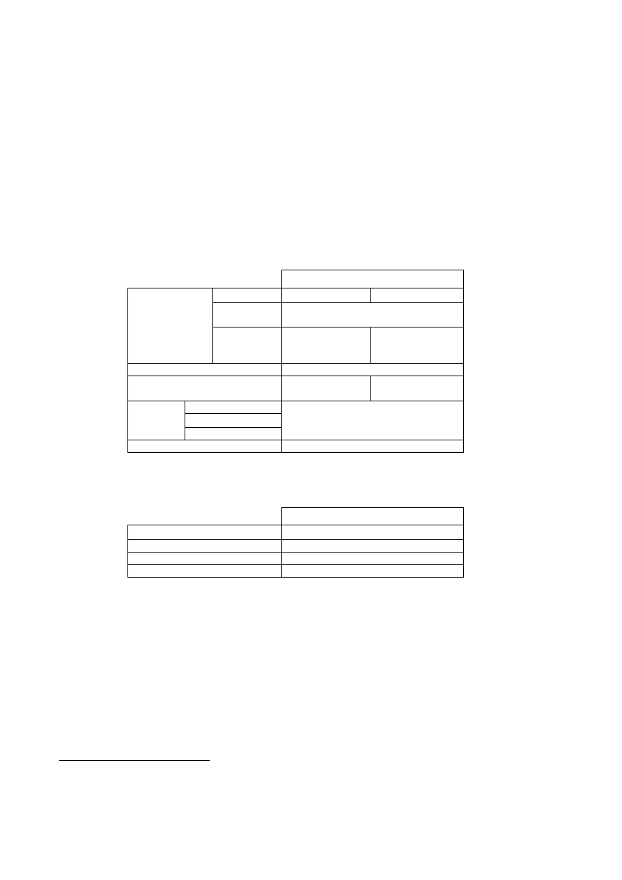
Open Service (positioning)
Carriers
Single Frequency
Dual-Frequency
8
Computes
Integrity
No
9
Type of Receiver
Ionospheric
correction
Based on simple
model
Based on dual-
frequency
measurements
Coverage
Global
Accuracy (95%)
10
H: 15 m
V: 35 m
H: 4 m
V: 8m
Alarm Limit
Time-To-Alarm
Integrity
Integrity risk
Not Applicable
Availability
99.8 %
Table 1 Service performances for the Galileo Open Service (positioning)
Open Service (timing)
Carriers
Three- Frequency
Coverage
Global
Timing Accuracy wrt UTC/TAI
30 nsec
Availability
99.8 %
Table 2 Service performances for the Galileo Open Service (timing)
Annex 4 includes the definitions of all the performance parameters used in the above tables and in
all the subsequent tables referring to Galileo Services.
Implementation
The Open Service signals are separated in frequency to permit the correction of errors induced by
ionospheric effects by differentiation of the ranging measurements made at each frequency. Each
navigation frequency will include two ranging code signals (in-phase and quadrature). Data are
8
The performances of a service with 3 carriers is under assessment.
9
Some level of integrity can be achieved through the application of RAIM techniques at user level (see Annex 4 for a
definition of RAIM).
10
Figures are based on use of 10 degrees mask angle.

GALILEO Services and Architecture
10
added to one of the ranging codes while the other “pilot” ranging code is data-less for more precise
and robust navigation measurements. The precise definition of Open Service signals is given in
section 4.1.2 and in Annex 2.
2.1.2 Commercial Service
Purpose
The Commercial Service will allow the development of professional applications, with increased
navigation performances and added value data, compared with the Open Service. The foreseen
applications will be based on:
• Dissemination of data with a rate of 500 bps, for added value services;
• Broadcasting of two signals, separated in frequency from the Open Services signals to
facilitate advanced applications such as integration of Galileo positioning applications with
wireless communications networks, high accuracy positioning and indoor navigation.
Performances and features
The Galileo Operating Company (GOC) will determine the level of performance it can offer for
each commercial service together with ascertaining the demands of Industry and the needs of the
consumer. It is intended to provide a guarantee for this service as outlined in section 2.5.
The Commercial Service will be a controlled access service operated by Commercial Service
Providers acting after a license agreement between them and the GOC.
Commercial service providers will make decisions on the offered services: e.g. integrity data,
differential corrections for local areas, etc… which will depend on the final characteristics of the
other services offered by Galileo.
Implementation
The Commercial Service signals will be the Open Services Signals, plus two encrypted signals
(ranging codes and data), on the “E6” band, as detailed in section 4.1.2 and Annex 2.
2.1.3 Safety of Life Service
Purpose
The target markets of the Safety of Life service are safety critical users, for example maritime,
aviation and trains, whose applications or operations require stringent performance levels.
This service will provide high-level performance globally to satisfy the user community needs and
to increase safety especially in areas where services provided by traditional ground infrastructure
are not available. A worldwide seamless service will increase the efficiency of companies operating
in a global basis, e.g. airlines, transoceanic maritime companies.
Performance and features
With regard to Safety of Life Services, there are certain levels of service that are stipulated by law
in various international transportation fields, for example Standards and Recommended Practices -
SARPS- by ICAO. A very specific level of service from Galileo will be needed to comply with
legislation applicable for all considered domains of transport and existing standards. It is intended
to provide a guarantee for this service as outlined in section 2.5.
This service will be offered openly and the system will have the capability to authenticate the signal
(e.g. by a digital signature) to assure the users that the received signal is the actual Galileo signal.
This system feature, which will be activated if required by users, must be transparent and non-
discriminatory to users and shall not introduce any degradation in performances.
GALILEO Services and Architecture
11
The provision of integrity
11
information at global level is the main characteristic of this service.
Non-European regions could also support the provision of this service on a regional basis by
delivering regional integrity information through the Galileo satellites.
The Safety of Life service will be provided globally according to the performances indicated in
table 3. These specifications include two levels to cover two conditions of risk exposure and are
applicable to many applications in different transport domains, for example air, land, maritime, rail:
• The Critical level covers time critical operations for example, in the aviation domain approach
operations with vertical guidance.
• The Non-Critical level covers extended operations that are less time critical, such as open sea
navigation in the maritime domain.
The SoL Service signals are in the E5a+E5b and L1 bands. Table 3 indicates the level of
performance that can be achieved by using only L1 and E5b frequencies. Galileo will offer a robust
service to the Safety of Life community providing also alternative levels of service for degraded
modes of operation (e.g. where one or two frequency would not be available due to interferences)
12
.
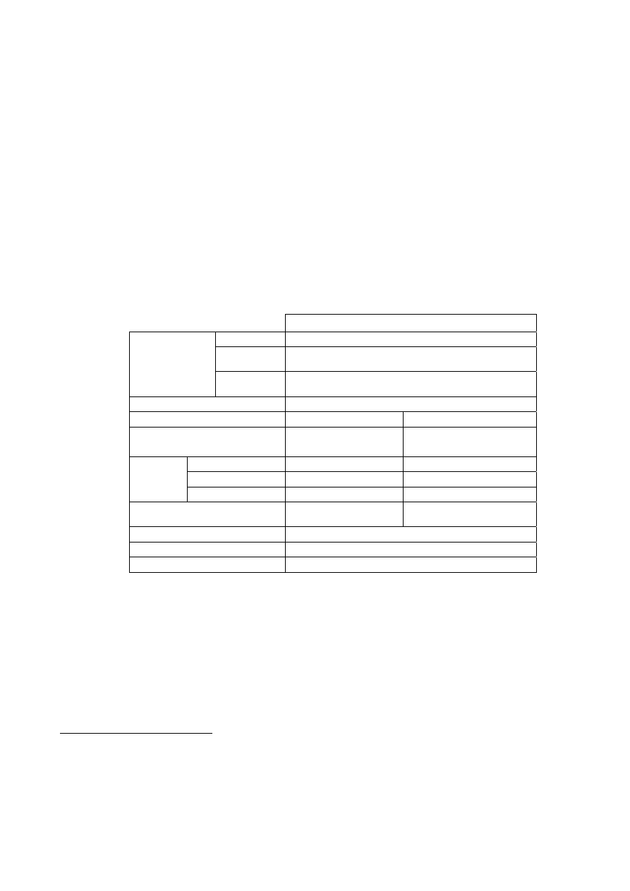
Safety-Of-Life Service
Carriers
Three Frequencies
13
Computes
Integrity
Yes
Type of Receiver
Ionospheric
correction
Based on dual-frequency measurements
Coverage
Global
Critical level
Non-critical level
Accuracy (95%)
H: 4 m
V: 8 m
H: 220 m
Alarm Limit
H: 12 V 20 m
H: 556 m
Time-To-Alarm
6 seconds
10 seconds
Integrity
Integrity risk
3.5x10
-7
/ 150 s
10
-7
/hour
Continuity Risk
10
-5
/15 s
10
-4
/hour – 10
-8
/hour
Certification/Liability
Yes
Availability of integrity
99.5%
Availability of accuracy
99.8 %
Table 3 Service performances for the Galileo Safety of Life Service
Implementation
The Safety of Life Service signals are separated in frequency to permit correction of errors induced
by ionospheric effects by differentiation of the ranging measurements made at each frequency.
Each navigation frequency will include two ranging code signals (in-phase and quadrature). Data
are added to one of the ranging codes while the other “pilot” ranging code is data-less for more
precise and robust navigation measurements. The integrity data will be broadcast in the L1 and E5b
11
Integrity is the ability of a system to provide timely warnings to the user when it fails to meet certain margins of
accuracy.
12
The performances of the single frequency services or other dual frequency services (e.g. E5a –L1) are under
assessment.
13
The SoL Service signals are in the E5a+E5b and L1 bands, but the level of performances indicated in the table can be
achieved by using only L1 and E5b frequencies. The performances of the service based on E5a+E5b and L1 frequencies
are under assessment.

GALILEO Services and Architecture
12
bands. The precise definition of the Safety of Life Service signals is given in section 4.1.2 and in
annex 2.
2.1.4 Public Regulated Service
Purpose
The Commission is proposing to the Council to add to the GALILEO Services a so called “Public
Regulated Service”.
The Public Regulated Service access will be controlled by the authorities to be defined at European
level, through the encryption of the signals and the appropriate key distribution.
Implementation
The PRS will provide a higher level of protection against the threats to Galileo Signals in Space
than is available for the Open Services (OS, CS and SoL) through the use of appropriate
interference mitigation technologies.
The need for the Public Regulated Service (PRS) results from the analysis of threats to the Galileo
system and the identification of infrastructure applications where disruption to the Signal in Space
by economic terrorists, malcontents, subversives or hostile agencies could result in damaging
reductions in national security, law enforcement, safety or economic activity within a significant
geographic area.
The objective of the PRS is to improve the probability of continuous availability of the signal in
space, in the presence of interfering threats, to those users with such a need. Applications include
the following:
a)
At European Level:
• Police services (EUROPOL, customs,…);
• Law Enforcement (e.g. EUROPOL, Transport Policy Regulations, OLAF)
• Emergency Services (e.g. Maritime Safety Agency, peace keeping forces, humanitarian
interventions….
b)
At Member States levels:
• Law enforcement and security;
• Customs;
• Intelligence Services.
The introduction of interference mitigation technologies carries with it a responsibility to ensure
that access to these technologies is adequately controlled to prevent misuse of the technologies
against the interests of Member States. Access to the PRS will be controlled through key
management systems approved by Member States’ governments.
GALILEO Services and Architecture
13
Performance and features
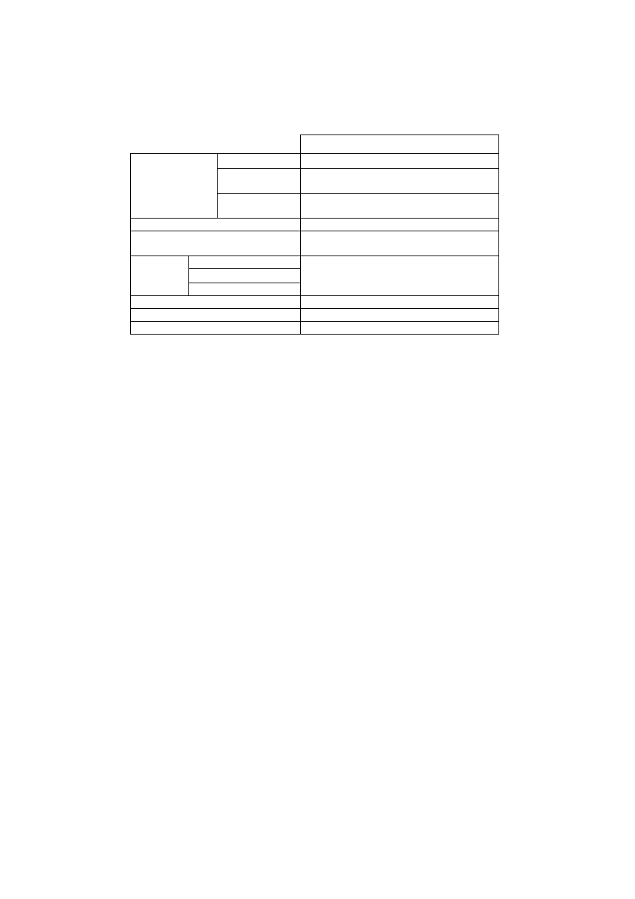
Public-Regulated Service
Carriers
Dual-Frequency
Computes
Integrity
Yes
Type of Receiver
Ionospheric
correction
Based on dual-frequency measurements
Coverage
Global
Accuracy (95%)
H: 6.5 m
V: 12 m
Alarm Limit
Time-To-Alarm
Integrity
Integrity risk
H:20-V:35
10 s
3.5 x10
-7
/150 sec
Continuity Risk
10
-5
/15 s
Timing Accuracy w.r.t. UTC/TAI
100 nsec
Availability
99.5 %
Table 4 Service performances for the Galileo Public Regulated Service
Implementation
The Public Regulated Service signals are permanently broadcast on separate frequencies with
respect to open Galileo satellite-only services, so as not to lose the PRS when the open service is
denied locally. They are wide band signals so as to be resistant to involuntary interference or
malicious jamming and therefore offer a better continuity of service.
The use of PRS will be restricted to clearly identified categories of users authorised by EU.
Member States will authorise users through the implementation of appropriate controlled access
techniques. Control of distribution of receivers will be maintained by Member States.
2.1.5 Galileo support to the Search and Rescue Service
Purpose
The Galileo support to the Search and Rescue service - herein called SAR/Galileo - represents the
contribution of Europe to the international COSPAS-SARSAT co-operative effort on humanitarian
Search and Rescue activities. SAR/Galileo shall:
• Fulfil the requirements and regulations of the International Maritime Organization (IMO) - via
the detection of Emergency Position Indicating Radio Beacons (EPIRBs) of the Global
Maritime Distress Security Service and of the International Civil Aviation Organisation (ICAO)
via the detection of Emergency Location Terminals (ELTs);
• Be backward compatible with the COSPAS-SARSAT system to efficiently contribute to this
international Search and Rescue effort.
Performances and features
SAR/Galileo will allow for important improvements of the existing COSPAS-SARSAT system:

GALILEO Services and Architecture
14
• near real-time reception of distress messages transmitted from anywhere on Earth (the
average waiting time is currently one hour);
• precise location of alerts (a few meters for EPIRBs and ELTs equipped with Galileo
receivers, while the current specification for location accuracy is 5 km);
• multiple satellite detection to avoid terrain blockage in severe conditions;
• increased availability of the space segment (27 Medium Earth Orbit satellites on top of the
four Low Earth Orbit satellites and the three Geostationary satellites in the current system).
In addition, SAR/Galileo will introduce a new SAR function namely, the return link from the SAR
operator to the distress emitting beacon, thereby facilitating the rescue operations and helping to
identify and reject the false alerts.
Galileo support to Search and Rescue Service (SAR/Galileo)
Capacity
Each satellite shall relay signals from up to 150 simultaneous
active beacons
Forward System Latency Time
The communication from beacons to SAR ground stations shall
allow for the detection and location of a distress transmission in
less than 10 min. The latency time goes from beacon first
activation to distress location determination.
Quality of Service
Bit Error Rate < 10
-5
for communication link: beacon to SAR
ground station
Acknowledgement Data Rate
6 messages of 100 bits each, per minute
Availability >
99.8%
Table 5 Service performances for the Galileo Search and Rescue Service
Implementation
The Search and Rescue Transponder on Galileo satellites detects the distress alert from any
COSPAS-SARSAT beacon emitting an alert in the 406 – 406.1 MHz band, and broadcasts this
information to dedicated ground stations in the “L6” band, as detailed in section 4.1.2.
COSPAS-SARSAT Mission Control Centres (MCC) carry out the position determination of the
distress alert emitting beacons, once they have been detected by the dedicated ground segment.
2.2 Locally assisted services
The Galileo Open, Commercial, Safety of Life and Public Regulated services will be, where
necessary, enhanced by means of the Galileo Local Component to satisfy higher user demands with
respect to accuracy, integrity, availability and communication over local areas. The Galileo Local
Component, which will consist of all Galileo Local Elements, is part of the overall Galileo
definition, and as such, the Galileo programme includes the design and development of a few
selected experimental Local Elements in order to determine and demonstrate the achievable
performance of local services.

GALILEO Services and Architecture
15
Whilst the Galileo Local Component is part of the overall Galileo definition, its deployment is not
covered within the deployment phase of the core Galileo system. It is however likely that both the
GOC and external service providers will deploy Local Elements on a Global scale, and which
together will offer ‘Regulated’ and ‘Unregulated’ services to a wide variety of users.
By defining Galileo Local Element performance standards it may also be possible to offer Galileo
Local Element Service guarantees, if the performance characteristics of the Local Elements to be
used meet or better those of the associated Local Element standard. Such guaranteed Local Services
are likely to be ‘Regulated’ by the GOC, which would use as input feedback from standing forums
established on a domain basis (road, rail, aviation, maritime etc). Both the GOC and external
service providers are likely to deliver such services to end users who will typically come from well-
established user communities with existing standards and regulations, and requiring a Local Galileo
Service Guarantee (typically Safety of Life).
‘Unregulated’ Local Services are also likely to be established autonomously by external service
providers, to meet purely commercial demands that have no strictly defined associated performance
requirements or need for a Local Galileo Service Guarantee.
The precise deployment, associated performances and functionality of Local Elements will be
driven by user and market needs, public regulation, economic factors and the existing proliferation
of networks (e.g. DGPS, GSM) which share a great deal of infrastructure and functionality required
by Galileo Local Elements. However four main service categories where Local Elements will play a
part can be identified using as basis specific functionality, and as such Local Element demonstrators
and complementary user terminals will be developed as part of the Galileo development and
validation phase for each of the following:
i
Local Precision Navigation Services: Galileo Local Elements providing differential code
corrections will nominally reach positioning accuracy better than 1 meter. Furthermore,
these local elements will have the potential to enhance the integrity alarm limits to a level
TBD with an associated time-to-alarm (TTA) of up to 1 second.
ii
Local High-Precision Navigation Services: The exploitation of the Three Carrier
Ambiguity Resolution (TCAR) technique with Galileo Local Elements will allow users to
determine their position with errors below 10 centimetres. The exact role of integrity with
respect to this service over and above that offered by the Local Precision Navigation Service
has yet to be determined.
iii
Local Assisted Navigation Services: By reducing the amount of information to be decoded
at the user terminal, it is possible to improve the availability of the SIS via improved Time
To First Fix (TTFF) and/or improved tracking threshold for all Galileo services, especially
when considering applications that operate in difficult environments (e.g. urban canyon and
indoor applications). This performance can be further improved by the additional use of the
Pilot Tones that exist on the Galileo Open Signals. This service is closely tied to
communication techniques (e.g. GSM/UMTS) due to the need for high levels of
communication (see Table 6).
iv
Local Augmented Availability Services: Local stations broadcasting satellite-like signals
(pseudolites) will also be used where necessary for increasing the availability of any Galileo
service in a defined local area. In addition, positioning performance will improved through
improved geometry and the fact that the pseudolite signal will not be subjected to the same
level of environmental distortion. Improved availability will be desirable in restricted
environments (e.g. urban) and for scenarios requiring a high level of availability (e.g.
aircraft landing).

GALILEO Services and Architecture
16
In all the above cases high potential service enhancement delivered by communications shall be
taken into consideration. The Galileo Local Component will offer a means of achieving the synergy
between the communication and positioning domains necessary to fully match the combined needs
of the various user applications, thus capturing the maximum market share possible. Such a need
and interest in the mutual added value brought about by such a combination has been expressed at
all user forums on Galileo services. The potential performance enhancement is well demonstrated
when the example of UMTS is used, as this can deliver bi-directional video, voice and/or data at a
capacity of up to 2 Mbps in comparison to the Galileo spacecraft only system that will offer a
500bps broadcast capability on the commercial service only. Every effort will therefore be taken to
ensure that harmonisation of position and communication using the Galileo Local Component is
achieved.
The following table indicates typical performances that are likely to be required/expected from
differential code, carrier and indoor assisted techniques under nominal environmental conditions.
Type of Local Elements
Broadcast of
differential corrections
Broadcast of
differential corrections
Indoor Assisted
Users
Accuracy (95%)
< 1 m
< 10 cm
50 m (TBC)
Integrity TTA
up to 1 second
TBD
TBD
Integrity Alarm Limit
TBD TBD TBD
Availability
99-99.95 (TBD)
99-99.9 (TBD)
99-99.9 (TBD)
Communications
Broadcast
Single/bi-directional
data
Single/bi-directional
data and voice
Table 6 Performance for Services combining Galileo and Local Elements
Almost all Galileo Local Elements and associated user terminals will also include additional GNSS
(e.g. GPS, GLONASS) and potentially terrestrial based positioning (e.g. E-OTD) functionality, and
as a result, the local services offered will be for combined services. In such instances when
combined services are being offered along with an associated Local Galileo service guarantee, this
guarantee will relate only to the performance of Galileo, and not that of the additional systems
included as part of the service.
2.3 EGNOS Services
EGNOS will provide a multimodal and civil service to different European user categories, namely:
general public/mass market users, specialist users and safety critical users. From this perspective,
EGNOS will be an early tool for the development of future Galileo applications, as the EGNOS
service will be available from 2004. EGNOS will be a market enabler for GALILEO.
EGNOS will provide 3 types of services:
• Ranging service: The EGNOS geostationary satellites will provide additional GPS-like ranging
sources.
• Wide area differential corrections: EGNOS will improve the accuracy of GPS and GLONASS
providing differential corrections.
• Integrity: EGNOS implements a warning of system malfunction (integrity) of GPS and
GLONASS constellations. The provision of this quality control service is essential for safety
critical applications.

GALILEO Services and Architecture
17
The EGNOS service will be a civil service offered openly. Although the EGNOS service is
conditioned to GPS availability, it is foreseen that a contractual relationship will be established
between the Service Provider and some users by which service guarantees may be given.
The EGNOS service performances and coverage area are defined in Annex 3. A prototype of
EGNOS the EGNOS Test Bed has been operational since February 2000 providing an experimental
signal.
According to the principles of an integrated strategic vision for the provision of European GNSS
new services can be defined as a result of combining Galileo satellite-only services (e.g. Open
service, Safety of Life service) and EGNOS services.
The combination of the Galileo Safety of Life service with the EGNOS service is of special interest.
This combined service will provide independent and complementary integrity information on the
Galileo and GPS constellations respectively, that may support for instance precision approach type
operations in the aviation domain, ensuring that sufficient redundancy exists to offer the prospect of
sole means availability, avoiding common failure modes, and thus allowing the rationalisation of
the terrestrial traditional radio-navigation infrastructure.
2.4 Combined services
Purpose
Galileo is being designed to be interoperable with other systems and, therefore, it will, in a great
many instances, be used as part of a combined service. The identification of combined services is
necessary to:
• Meet the most demanding user applications.
• Reduce satellite navigation system weaknesses.
• Provide robust solutions for applications requiring system redundancy for safety and/or
security reasons.
• Access future GNSS market.
• Enable and expand new market opportunities.
The exact role that Galileo service guarantees can play in combined services with other systems
needs to be elaborated based upon the specific features of these services and the specifications in
section 2.6 on Galileo stand-alone service guarantees, section 3.2 devoted to locally assisted
services and section 3.3 focused on EGNOS services.
In the case of a guarantee of a combined service, such services are likely to be regulated by the
GOC, which will only held responsibility on Galileo performances, and delivered in conjunction
with the external service providers to end users who will typically come from user communities
with existing standards and regulations.
External service providers may also autonomously establish unregulated combined services for
users with no service guarantees on a purely commercial basis.
2.4.1 Services resulting from combination of Galileo with other GNSS systems
The most obvious systems to be combined with Galileo are the other existing GNSS systems, GPS,
GLONASS, SBAS and GBAS as they share with Galileo a great many characteristics that facilitate
a combination at user level. In addition, these GNSS systems can be further enhanced through local
elements (see section 4.2)

GALILEO Services and Architecture
18
Performances and features
By combining Galileo with other GNSS systems, improved performance in the following domains
can be expected:
• Availability: Using as an example Galileo in combination with GPS and SBAS systems, the
number of operational satellites will be in the region of 60. In normal urban environments
this would result in an increased availability for 4 satellites from 40% to more than 90%.
• Position Accuracy: Allied to an increased availability in restricted environments (urban) is a
better geometry of spacecraft or enhanced positioning performance.
• Integrity: SBAS systems, in addition to generating ranging signals, provide integrity
information on GPS and GLONASS. Thus if an application requires the broadcast integrity
information of two systems this can be achieved using SBAS. Typically, Safety of Life
applications would benefit from this additional service.
• Redundancy: By combining services from separate and fully independent systems full
redundancy can be achieved. This is particularly important for Safety of Life applications
that require full system backup.
A first assessment of Galileo and GPS combined service performances have been carried out with
the following estimated results (99% availability, world-wide):
Galileo OS
(10° m.a
14
.)
single
frequency
receiver
Galileo OS
+ GPS (10°
m.a.) single
frequency
receiver
Galileo OS
(10° m.a.)
dual
frequency
receiver
Galileo OS
+GPS (10°
m.a.) dual
frequency
receiver
Galileo OS
(30° m.a.)
single
frequency
receiver
Galileo OS
+ GPS (30°
m.a.) single
frequency
receiver
Horizontal
accuracy
15 7-11 4 3-4 14-54
11-21
Vertical
accuracy
35 13-26 8 6-8 21-81
17-32
Table 7 Galileo OS and GPS combined service performances
Implementation
Detailed studies of combined service features will be performed under the Joint Undertaking
framework in co-ordination with service providers.
Nevertheless, studies on the elaboration or revision of existing Galileo Interface Control Documents
(ICDs) to other systems, receiver architecture trade-offs and assessment of combined service
performances have been initiated.
2.4.2 Services resulting from Galileo with non-GNSS systems
Whilst other GNSS systems make ideal candidates for combination with Galileo, some inherent
weaknesses, such as weak signal strength and limited communication capability can only be solved
through combination with other existing non-GNSS navigation (Loran-C) and communication
systems (UMTS) or even with on-board sensors (INS). Such systems can be grouped into the
following categories:
14
m.a. = masking angle

GALILEO Services and Architecture
19
Performance and features of combined services for positioning
• Other non satellite-based radio navigation systems (e.g. LORAN-C): Such systems may
offer improved signal strength, which provides better indoor penetration and resistance to
jamming. Such systems may also offer a limited communication capability (EUROFIX)
• Mobile communication networks (e.g. GSM, UMTS): These systems can be considered as
positioning systems offering a complementary positioning capability (e.g. E-OTD) to the
user in satellite critical environments. The complementary positioning, calculated either by
the network and relayed to the user under request or by the user equipment, can be
hybridised with the Galileo position solution in the user equipment. In addition, a different
solution combining communication-ranging sources (e.g. Observed Time Difference
measurements derived from GSM Base Stations) with Galileo ranges in a hybridised
receiver will also allow positioning enhancement performances (accuracy, availability) in
critical environments.
• Motion Sensors (e.g. odometers, INS): When combined in hybridised receivers, short-term
outages of the Galileo signal can be overcome by forward interpolation. This combination
provides an enhancement of Galileo service robustness and availability, especially in urban
environments, where such short term outages are common place.
Performance and features of combined navigation-related communication services
• Telecommunication systems (e.g. UMTS, INMARSAT): The harmonisation of the
positioning and communication domains is necessary to match combined needs of user
applications (e.g. SAR, emergency services, personal handsets) enabling the introduction of
GNSS technology in the future market applications. In this sense, communication systems
offer a means for transferring additional GNSS data to allow enhanced positioning
performances (e.g. accuracy) as well as better communication capabilities (e.g. higher data
rates, bi-directional data links). As a consequence, the expected benefits that the synergy of
the combination of Galileo with these systems will bring are threefold:
a) Enabling the enhancement of the data link characteristics of the Galileo stand-alone
or locally assisted services (see section 3.2). This can be the case for the
improvement of commercial service data rate or the optimisation of the
communication capabilities of the local elements.
b) In addition, performance enhancement can be achieved using communication
systems functionalities as bearers of positioning data messages. This is the basis for
differential GNSS or assisted GNSS functionalities where, for particular
applications, the user terminal can be assisted in the positioning computation in
difficult environments with additional information (e.g. ephemeris) transmitted on
generally dedicated communication links. These functionalities are also applicable to
Galileo local elements (see section 4.2)
c) Enabling the provision of GNSS added value services through the relay by such
systems of additional associated information or additional navigation related data
(e.g. electronic maps) to be transmitted to the user or a 3
rd
party (e.g. a service
centre)

GALILEO Services and Architecture
20
Implementation
Studies have been initiated to assess technical solutions and elaborate the corresponding ICDs
between the core Galileo system and the external systems to maximise the ease of implementation,
use and benefit of this combination.
Solutions may differ as some Galileo services, such as the commercial service, were conceived to
support integration with communication systems. Furthermore, specific local components can be
designed to achieve the greatest advantages from the combination of Galileo with such systems (see
section 4.2). The refinement of the results has to be co-ordinated with service providers.

GALILEO Services and Architecture
21
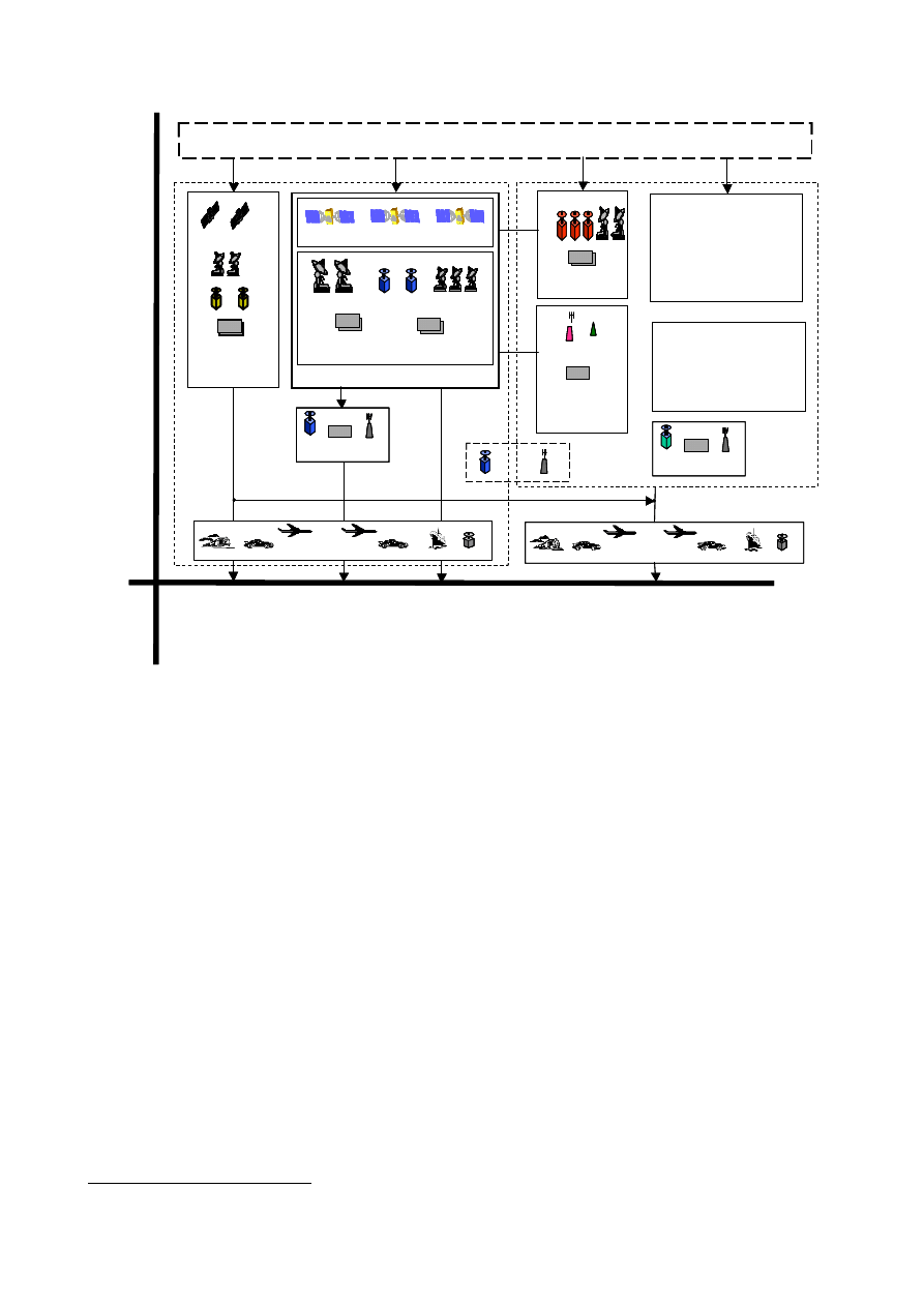
3 Galileo System
The Galileo architecture is the result of the system design activities that have been driven by the
services defined in the previous section. The architecture at this stage of the project has been
designed to be flexible in order to:
• be adaptable to mission requirements changes.
• allow for a gradual implementation of the services described in section 3
• deal with configuration changes of system elements.
A service-oriented approach has been used to define the different components of the Galileo
system. Different parts of the Galileo infrastructure are needed to provide the types of service
defined in section 3, Galileo satellite-only services, Locally assisted services, EGNOS services and
Combined services. According to the participation of each part of the infrastructure to the provision
of the services, the Galileo system components have been grouped into the following categories:
• Global component
The Global component is the core infrastructure of the Galileo system that contains all
necessary elements to provide the Galileo-satellite only services as described in section 3.1.
This component is described in section 4.1.
• Local component
The local component is part of the Galileo design and is needed to provide the locally assisted
services as described in section 3.2. The Galileo programme includes the development of a few
selected experimental local elements to validate performances and the interfaces between the
core system and its local augmentation. These experimental local elements are described in
section 4.2.
• EGNOS
The EGNOS system is the infrastructure needed to provide the services described in section 3.3
of this document. The co-location of some EGNOS and Galileo sites is being considered, in the
on-going technical studies, to optimise resources. However, the EGNOS system will be kept
functionally independent from the Galileo global component to avoid common mode of failures.
• User segment
The user segment is the component of the system that will receive and process Galileo signals
and the signals coming from other systems to get the Galileo services. The user segment is
described in section 4.4.
• External Galileo-related systems components
The non-European Integrity Segments and the Search and Rescue System will have interfaces
with the Global component. These components are described in section 4.5.
GALILEO Services and Architecture
22
Non-European
Regional components
Local Components
User Receivers
Global component
Space Segment
Ground Segment
Search & Rescue
COSPAS-SARSAT
MCC
MEO-LUT Beacon
EGNOS
Control Stati ons
Uplink Stations
Reference Stations
Galileo C ontrol
Center
Orbit Contr ol
Center
Galileo components
External Systems
Locally
Assisted
services
Satellite-only
services
S
ys
tem
s
com
ponen
ts
EGNOS
services
GNSS Systems
(e.g. GPS and
GLONASS)
GSM, UMTS
Local Components
Combined
services
User Receivers
Master Control
Centers
Reference Stations
Uplink
Stations
GEO satellites
S
er
vi
ce
s
Service Centers
Navigation systems
Communication
systems
Local
Components
Non-European
Regional components
Local Components
Local Components
User Receivers
Global component
Space Segment
Ground Segment
Search & Rescue
COSPAS-SARSAT
MCC
MEO-LUT Beacon
Search & Rescue
COSPAS-SARSAT
MCC
COSPAS-SARSAT
MCC
MEO-LUT Beacon
EGNOS
Control Stati ons
Uplink Stations
Reference Stations
Galileo C ontrol
Center
Orbit Contr ol
Center
Galileo components
External Systems
Locally
Assisted
services
Satellite-only
services
S
ys
tem
s
com
ponen
ts
EGNOS
services
GNSS Systems
(e.g. GPS and
GLONASS)
GSM, UMTS
Local Components
Combined
services
User Receivers
Master Control
Centers
Reference Stations
Uplink
Stations
GEO satellites
S
er
vi
ce
s
Service Centers
Navigation systems
Communication
systems
Local
Components
Figure 1 Systems components mapped into services
3.1 Global component
The infrastructure described in this section allows the provision of the Galileo satellite-only
services. It is comprised of the space segment made of 27 active satellites + 3 spare satellites, and
its associated ground segment.
3.1.1 Space segment
The Galileo Space Segment will comprise a constellation of a total of 30 MEO satellites, of which 3
are spares, in a so-called Walker 27/3/1
15
constellation, see table 8. The satellites include:
o A platform
o A navigation payload
o A Search and Rescue payload.
Each satellite will broadcast precise time signals, together with clock synchronisation, orbit
ephemeris and other data. The Galileo satellite constellation has been optimised to the following
nominal constellation specifications:
15
These figures represent 27 satellites in 3 planes equally spaced.
GALILEO Services and Architecture
23
• Circular orbits with a semi-major axis of 29 994 km (which corresponds to 23616 km
altitude);
• Orbital inclination of 56°;
• Three equally spaced orbital planes;
• Nine operational satellites, equally spaced in each plane;
• One spare satellite (also transmitting) in each plane.
Orbital and constellation parameters of Galileo and GPS will therefore be different. At any time and
at any location on earth the maximum number of visible satellites is calculated to be:
Receiver elevation
masking angle
Number of visible
Galileo satellites
Number of visible
GPS satellites
Total
5° 13 12 25
10° 11 10 21
15° 9 8 17
Table 8 Maximum number of visible satellites for various masking angles
3.1.2 Signal in Space (SIS)
Ten navigation signals and 1 SAR signal are provided by the satellite constellation. In accordance
with ITU (International Telecommunication Union) regulations, Galileo navigation signals will be
emitted in the RNSS allocated bands, and the SAR signal will be broadcast in one of the frequency
bands reserved for the emergency services (1544-1545 MHz).
The following chart describes the Galileo navigation signals emission:
• 4 signals are transmitted in the frequency range 1164-1215 MHz (E5a-E5b)
• 3 signals are transmitted in the frequency range 1260-1300 MHz (E6)
• 3 signals are transmitted in the frequency range 1559-1591 MHz (L1)
The detailed definition of the Galileo signals is provided in Annex 2.
E5A
1575
1278
13
00M
Hz
1164M
Hz
1215M
H
z
12
60M
Hz
1559M
Hz
1591M
Hz
Upper L-Band
Lower L-Band
1176
1207
E5B
E6
L1
E2
E1
FREQUENCY
(MHZ)
IN
PH
A
S
E
IN
QUA
DR
AT
UR
E
1
2
3
4
5
6
7
8
9 10
SAR
DO
W
NL
IN
K
11
L6
E5A
1575
1278
13
00M
Hz
1164M
Hz
1215M
H
z
12
60M
Hz
1559M
Hz
1591M
Hz
Upper L-Band
Lower L-Band
1176
1207
E5B
E6
L1
E2
E1
FREQUENCY
(MHZ)
IN
PH
A
S
E
IN
QUA
DR
AT
UR
E
1
2
3
4
5
6
7
8
9 10
SAR
DO
W
NL
IN
K
11
L6
Figure 2 Galileo Signal In Space Description
Each navigation signal consists of a ranging code and data. There are different types of ranging
codes and different types of data, which can be used for Galileo signals.
Ranging codes
The ranging code is a sequence of –1 and +1 with specific characteristics in the time (code length)
and frequency (chip rate) domains. There is one unique sequence for each signal coming from a
given satellite. Ranging codes are either publicly known, when the code is actually published, or
known only to the authorised users, when the code is encrypted.

GALILEO Services and Architecture
24
There are three types of ranging codes:
• Open access ranging code (publicly known, unencrypted)
• Ranging codes encrypted with commercial encryption
• Ranging codes encrypted with governmental encryption
Data
There are five types of data: basic navigation data, integrity data, commercial data, PRS data, and
SAR data. These data are either open access data (navigation data, integrity data
16
, SAR data) or
protected data (commercial data using commercial encryption, PRS data using governmental
encryption).
Services allocation within Galileo signals
Both the ranging code and data carry the specific information needed for a specific service. Among
the 10 navigation signals:
• 6 are designed for OS and SoL (signals 1,2,3,4,9,10 of
Figure 2
)
• 2 are designed specifically for CS (signals 6,7 of
Figure 2
)
• 2 are designed specifically for PRS (signals 5,8 of
Figure 2
)
Table 9 summarises the navigation signals characteristics and their service allocation:
Navigation Services
Signals characteristics
Signal
s id.
Frequen-
cies
OS
CS
SoL
PRS
Ranging
Code Type
Data Type
17
1,2,3,
4,9
and
10
E5a
E5b
L1
X X X Open
Access
Navigation data
Integrity data
SAR data
18
,
Commercial data
19
6, 7
E6
X
Commercial
encryption
Commercial data
5,8
E6
L1
X
Governmental
encryption
PRS data
Table 9 Navigation signals characteristics and their service allocation
Note: The SAR distress messages (from distress emitting beacons to SAR operators), will be
detected by the Galileo satellites in the 406-406.1 MHz band, and then broadcast to the dedicated
receiving ground stations in the 1544-1545 MHz band, called L6 (below the E2 navigation band).
The SAR data, from SAR operators to distress emitting beacons, will be used for alert
acknowledgement and co-ordination of rescue teams, and will be embedded in the navigation data
of the Open Service Signal emitted in the L1 band.
16
A capability of integrity data encryption is envisaged.
17
Pending final service data allocation
18
This SAR data correspond to the information sent from SAR operators to the distress emitting beacons: alert
acknowledgement, coordination of rescue teams.
19
Possibility to include commercial data is under assessment

GALILEO Services and Architecture
25
3.1.3 Ground segment
The two basic functions of the ground segment are satellite control and mission control. Satellite
control includes management of the constellation through monitoring and control using the TT&C
(Telemetry Tracking & Command) uplinks. Mission control will globally control the core functions
of the navigation mission (orbit determination, clock synchronisation) and determine and
disseminate (via the MEO satellites) integrity information (warning alerts within time-to-alarm
requirements) on a global basis. The ground segment assets are as follows:
• The Galileo Control Centre is at the heart of the system and includes all control and
processing facilities. The main function of the Control Centre includes Orbit Determination
and Time Synchronisation, global satellite integrity determination, maintaining Galileo
system time, monitoring and control of the satellites and of the services provided by these,
and various off-line maintenance tasks.
• Galileo Sensor Stations collecting navigation data from the Galileo satellites as well as
meteorological and other required environmental information. This information is passed to
the Galileo Control Centre for processing.
• Galileo Up-link Stations that include separate two-way Tracking, Telemetry and Command
stations in the S-band, specific Galileo mission related up-links in the C-band, and Galileo
Sensor Stations.
• Mission Uplink Stations with only mission related C-band uplinks.
• Global Area Network to provide a communication network linking all system elements
around the world.
Moreover, a Service Centre will be implemented with the objective of providing an interface to
users and value added service providers for programmatic and commercial issues. Where
appropriate for the different service categories, this centre performs functions such as providing:
o Information and warranty on performances and data archiving;
o Information on current and future Galileo system performances;
o Subscription and access key management;
o Certification and license information;
o Interface with non-European regional components;
o Interface with Search and rescue service providers;
o Interface with the Galileo commercial service providers.
The definition of the role of the Services Centres will be refined in co-ordination with the Joint
Undertaking.
3.2 Local components
The Galileo Local Component, which is made up of all Galileo Local Elements, is part of the
overall Galileo definition, and as such, the Galileo programme includes the design and development
of some experimental Local Elements based upon specific functionality necessary to meet
associated service requirements.
Galileo Local Elements will provide, where necessary, enhanced system performance and the
possibility to combine Galileo with other GNSS systems and terrestrial based positioning and
communication systems on a local basis (e.g. D-GNSS, Loran-C, and UMTS) to a wide variety of
users.

GALILEO Services and Architecture
26
In order to fulfil the four main service category requirements discussed in Section 3.3 the following
system functionality is required from the corresponding Local Element Demonstrators:
i.
Local Precision Navigation Elements: providing local differential correction signals (for
example by radio data broadcast or by GSM or UMTS) which user terminals can use to
adjust the effective range of each satellite to correct for ephemeris and clock inaccuracies
and to compensate for tropospheric, and in the case of signal frequencies, ionospheric delay
errors. It will also be possible to enhance the quality of the integrity information in terms of
both Alarm Limit and TTA. It is expected that existing signal formats (RTCM, RTCA) will
be adapted to accommodate all additional Galileo data.
ii.
Local High-Precision Navigation Elements: providing local differential data signals (for
example by radio data broadcast or by GSM or UMTS) which Three Carrier Ambiguity
Resolution (TCAR) user terminals can use to adjust the effective range of each satellite to
correct for ephemeris and clock inaccuracies and compensate for tropospheric and
ionospheric delay errors. Again, it is expected that existing signal formats (RTCM, RTCA)
will be adapted to accommodate the additional Galileo data.
iii.
Locally-Assisted Navigation Elements: can use one or two-way communication
functionality (for example by GSM or UMTS) to assist the user terminal in position
determination in difficult environment. In a user terminal centred approach, one way
communication is required deliver to the user terminal satellite information (e.g. ephemeris
and Doppler) that can be used to reduce the time to first fix, enabling the user terminal to
determine its own position much more quickly from newly acquired satellite signals than
would otherwise be possible. This information also can reduce the tracking threshold of the
SIS within the user terminal, which also results in improved availability. In a service centre
approach, two-way communication is needed to enable received pseudorange information at
the user terminal firstly to be transmitted back to a central processing facility, where the
position is computed before being re-transmitted back to the user terminal in the field.
Again, the need not to demodulate and receive additional satellite information reduces the
TTFF and increases the tracking threshold. In both cases, the addition of Pilot Tones on the
Open Service signals can further improve tracking threshold performance.
iv
Local Augmented-Availability Navigation Elements: providing local supplementary
“pseudolite” transmissions that the user terminal can use as if they were additional Galileo
satellites to compensate the satellite visibility under restricted field of view or high
availability requirement scenarios. This local ranging information is also nominally of a
higher quality than those received from the Galileo satellites, as it is not subject to the same
levels of environmental distortion.
In order to test, validate and demonstrate the improved performance delivered by each of these
Local Element demonstrators, it will be necessary to develop associated user terminals with the
appropriate additional functionality necessary to interact appropriately with the Local Element. The
relationship to the core Galileo receiver of Local Element and indeed external complementary
system functionality is represented in Figure 4 of this document, and needs to be fully considered
when defining the various complementary user terminals to be produced as part of the development
and validation phase of the Galileo programme. This is particularly the case when dealing with
Locally Assisted Navigation Services, as they require a close synergy between the Galileo Receiver,
the associated Local Element and the method of communications (GSM/UMTS), typically
combined at the user terminal level as a mobile phone handset.
In order to maximise the ease of implementation, use and benefit of all such Galileo Local
Elements, Interface Control Documents (ICD’s) will be defined between the ‘Core’ Galileo system
and external systems, in particular mobile communication systems, such as UMTS, that have been

GALILEO Services and Architecture
27
identified as having a future role in providing local augmentation to that satellite based Galileo
services.
The existence of the Galileo local elements on one hand, and the proliferation of the mobile
communication infrastructure on the other, offer major opportunity to build up applications based
on the synergy of two basic functions (navigation and data transmission). Consequently, such a
synergy will directly allow for the development of the Galileo market share.
This will also be the case for the definition of Services Centres, which may provide to the user
community, via Local Elements, additional value added services and data (e.g. planned satellite
outages, improved ephemeris/clock predictions).
With Local Elements being Globally proliferated, the potential will also exist to use the quality of
the received SIS at the Local Elements to aid in the identification and isolation of interference
sources to the Galileo SIS. This additional functionality could be of great benefit to Galileo and
indeed GNSS, as the SIS are very weak and as such are particularly susceptible to many forms of
interference that at best degrade performance and at worst completely deny it, and as such deserves
further investigation.
3.3 EGNOS
EGNOS is composed of four segments: ground segment, space segment, user segment and support
facilities.
# The EGNOS Ground Segment consists of GNSS (GPS, GLONASS, GEO) Ranging and
Integrity monitoring Stations (called RIMS), which are connected to a set of redundant
control and processing facilities called Mission Control Centre (MCC). The MCC
determines the integrity, PseudoRange differential corrections for each monitored satellite,
ionospheric delays and generates GEO satellite ephemeris. This information is sent in a
message to the Navigation Land Earth Station (NLES), to be uplinked along with the GEO
Ranging Signal to GEO satellites. These GEO satellites downlink this data on the GPS Link
1 (L1) frequency with a modulation and coding scheme similar to the GPS one. All ground
Segment components are interconnected by the EGNOS Wide Area Communications
Network (EWAN);
# The EGNOS Space Segment is composed of geostationary transponders with global Earth
coverage. The EGNOS AOC system is based on INMARSAT-3 AOR-E and IOR, and the
ESA ARTEMIS navigation transponders;
# The EGNOS User Segment consists of an EGNOS Standard receiver, to verify the Signal-
In-Space (SIS) performance, and a set of prototype User equipment for civil aviation, land
and maritime applications. That prototype equipment will be used to validate and eventually
certify EGNOS for the different applications being considered;
# The EGNOS support facilities include the Development Verification Platform (DVP), the
Application Specific Qualification Facility (ASQF) and the Performance Assessment and
System Checkout Facility (PACF). Those are facilities needed to support System
Development, Operations and Qualification.
The EGNOS elements will be kept functionally independent from the Galileo global component to
avoid common mode of failures.
3.4 User segment
The User Segment means the family of different types of user receivers, with different capabilities
of using the Galileo signals in order to fulfil the different Galileo services.
GALILEO Services and Architecture
28
To fully benefit all the Galileo services (global, local, combined), the users must be equipped with
adequate multi-functional terminals. The functions implemented in the User Terminal should
allow him to:
• Function 1: receive directly the Galileo Signal in Space (i.e. the GALIEO receiver);
• Function 2: have access to the services provided by the regional and local component;
• Function 3: be interoperable with other systems.
USER TERMINAL
GLOBAL
Component
Regional
Component
Local
Component
Galileo SIS
Interoperable
systems
• GPS
• UMTS
• Hybrid sys.
• …
Function 1
Galileo
Receive
Function 2
Function 3
Other functions
power supply,
USER TERMINAL
GLOBAL
Component
Regional
Component
Local
Component
Galileo SIS
Interoperable
systems
• GPS
• UMTS
• Hybrid sys.
• …
Function 1
Galileo
Receive
Function 2
Function 3
USER TERMINAL
GLOBAL
Components
Regional
Components
Local
Components
Galileo SIS
Interoperable
systems
•GPS
•UMTS
Function 1
Galileo
Receiver
Function 2
Function 3
Other functions
(maps,
power supply,
MMI…)
Navigation
Communication
•Mobile comm.
Figure 3 User terminal receiver
As with Galileo Local Components, Galileo receivers will be designed and built as part of the
Galileo Development Phase. All performance characteristics of the Galileo services will be
referenced to the performance characteristics of these receivers, and as such all subsequently
developed user receivers will have to meet the same performance characteristics if the same levels
of service are to be reached.
The first function is performed by the Galileo receiver, which constitutes the baseline of any Galileo
terminal. The second and third functions are optional and depend on application needs. Some of
these functions can technically be performed by the same physical component. By example, the
interoperability with GPS and the reception of the Galileo SIS could be performed by a single
combined receiver. In addition, the reception of local components data and the interoperability with
UMTS could be performed by the same hardware component.
As the performance of different Galileo services are defined at user level, some standard terminals
will be developed to demonstrate the achievable performance.
3.5 External Galileo-related system components
3.5.1 Non-European Regional Components
Should non-European regions choose to supplement Galileo’s global integrity, Regional
Components consisting of ground segments dedicated to Galileo integrity determination over their
specific area could be envisaged. The deployment, operation and funding of these components will
GALILEO Services and Architecture
29
be under the responsibility of the respective regional service providers. The regional integrity data
could be routed to the Galileo ground segment for up-linking to the satellites together with the
Galileo and other service provider’s data.
3.5.2 Search and Rescue systems
The SAR/Galileo service is a support to the international COSPAS-SARSAT system. The complete
SAR mission consists of:
# A User Segment (called distress beacons), which in case of a distress situation transmits
an alert message, in the 406-406.1 MHz;
# A space segment, which detects the alert messages transmitted by distress beacons, and
broadcast them globally in a portion (100kHz) of the 1544-1545 MHz band;
# A dedicated ground segment, called Local Users Terminals (LUTs), which receives and
process the alerts relayed by the space segment. The LUTs are designed to receive the
alert messages relayed by LEO satellites (LEOLUTs), GEO satellites (GEOLUTs), or
MEO satellites like Galileo (MEOLUTs);
# Mission Control Centres, which validate the alert information and distribute it to the
Rescue Team of the Rescue Co-ordination Centres (RCC).
The contribution of the SAR/Galileo service to the international mission consists of:
# The SAR payload on board the Galileo satellites;
# The design of the receiving ground stations (MEOLUTs). Some five MEOLUTs
adequately implemented around the world will be sufficient to perform a global
coverage;
# The introduction of a new function (a return link from the Rescue teams to the distress
alert transmitting beacons). This return message will be elaborated by a “Return Link
Service Provider” (RLSP). The SAR operators (RCC) will designate the RLSP, which
will interface with the Galileo ground .The return message will be uplink by the Galileo
ground segment.
Space Segment
First Generation
Beacons
Galileo
Ground
Segment
SAR
Ground
Segment
MEOLUT
Second Generation
Beacons
Third Generation Beacons
RLSP
MCC
RCC
SAR Payload
Mission
Uplink
User Segment
Ground Segment
Galileo Satellite
Space Segment
First Generation
Beacons
Galileo
Ground
Segment
SAR
Ground
Segment
MEOLUT
Second Generation
Beacons
Third Generation Beacons
RLSP
MCC
RCC
SAR Payload
Mission
Uplink
User Segment
Ground Segment
Galileo Satellite
Figure 4 SAR Galileo system
First Generation Beacon
distress beacon, without GNSS receiver, located by Doppler effect
Second Generation Beacon
distress beacon with GNSS receiver, and location information
inserted in the distress message

GALILEO Services and Architecture
30
Third Generation Beacon
as second generation, plus the capability to extract return link
information from the navigation message
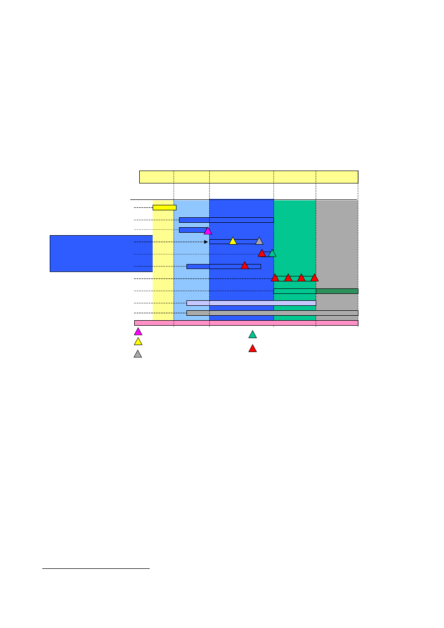
GALILEO Services and Architecture
31
4 Development Plan
The current development plan for Galileo is illustrated in Figure 5 below. Following the Definition
phase, the Development & Validation phase covers the detailed design, manufacture and test of the
system components leading to system validation. System validation will be performed using ground
simulation facilities and in-orbit experimentation. A major tool for this work will be the Galileo
System Test-bed (GSTB-V1: on-ground system test-bed, GSTB-V2: in-orbit system test-bed) for
which the first experimental satellite is planned to be launched towards the end of 2004.
2000 2001 2002 2003 2004 2005 2006 2007 2008 …..
Technology Developments
Definition
DEFINITION
DEVELOPMENT & VALIDATION
DEPLOYMENT OPERATIONS
PSDR: Preliminary System Design Review
S-CDR: System Critical Design Review
SQR: System Qualification Review
IOVR: In-Orbit Validation Review
Launches
Development & Validation
PHASE B2
Test Bed (GSTB)
PHASE CD
In-Orbit Validation (IOV)
PSDR
S-CDR
SQR
IOVR
Full Deployment
Operations
User Receiver / Applications
Local Elements
Figure 5 Development Schedule
Following the completion of key system validation milestones and any subsequent design updates,
the deployment phase consists of gradually deploying the space segment and ensuring full
deployment of the ground infrastructure. Studies are ongoing to analyse the provision of an initial
operational capability as soon as possible, for instance a limited constellation size and reduced
ground segment functionalities, followed by full deployment of operational capability by 2008.
The operations phase will cover the operations of the system (ground facilities and satellites) and
the replenishment of satellites for an indefinite period
20
.
The development plan will take account of the progress of international negotiations and
standardisation.
• Launching the satellites of the various Galileo programme phases requires an optimised
deployment scenario. One Galileo System Test-Bed (GSTB-V2) satellite must be launched
in 2004, the first four operational satellites of the IOV phase will be launched in 2005, and
20
For costing purposes a period of 20 years has been adopted. This includes a full constellation replacement.

GALILEO Services and Architecture
32
the full deployment to reach the 30-satellite Galileo constellation will be performed by the
end of 2007.
During the operational phases, maintenance flights will be needed to replace single satellites, once
they have been placed out of service. The launchers adequate to perform these flights will be chosen
during the definition of the maintenance scenarios, which is to be discussed at later programme
phases.
5 Organisation of the programme
5.1 Overall organisation during Development and Validation Phase
For the implementation of the Development and Validation phase of the Galileo programme, the
management approach will be structured in such a way as to ensure the unity of the management
including the financial control of the programme.
The organisational scheme is centred on the establishment, by initially the European Commission
and the European Space Agency, of a legal entity, i.e. the Galileo Joint Undertaking (JU), for a
period of four years.
The main tasks of the JU are:
• to oversee the optimal integration of EGNOS in Galileo and the implementation of the
Galileo development and validation phase;
• to launch in cooperation with ESA, the research and development activities needed to
successfully complete the development and validation phase, preparing the deployment
phase;
• in cooperation with EC, ESA and the private sector, to help to mobilise the public and
private funds needed for the deployment and operations phases, i.e.:
o to draw up a business plan covering all the phases of the programme,
o to negotiate an overall financing agreement setting out the responsibilities, roles and risk
to be shared between public and private sectors, by way of a competitive tendering
process
o to supervise the carrying-out of all Galileo programme elements and to make any
necessary adjustments during the development phase
The central objective of this tendering or concession awarding process is to start a risk mitigation
process for the potential future concessionaire whereby it will be necessary to acquaint potential
final bidders with the management scheme and programme inherent risks.
Private entities can be invited to join the JU-structure once the tendering procedure of the
concession has been finalised in order to avoid conflicts.
Through an agreement concluded between the Joint Undertaking and the European Space Agency,
the latter is in charge of carrying-out the activities required during the Development and Validation
Phase with regard to the space segment and the earth segment associated with the system.
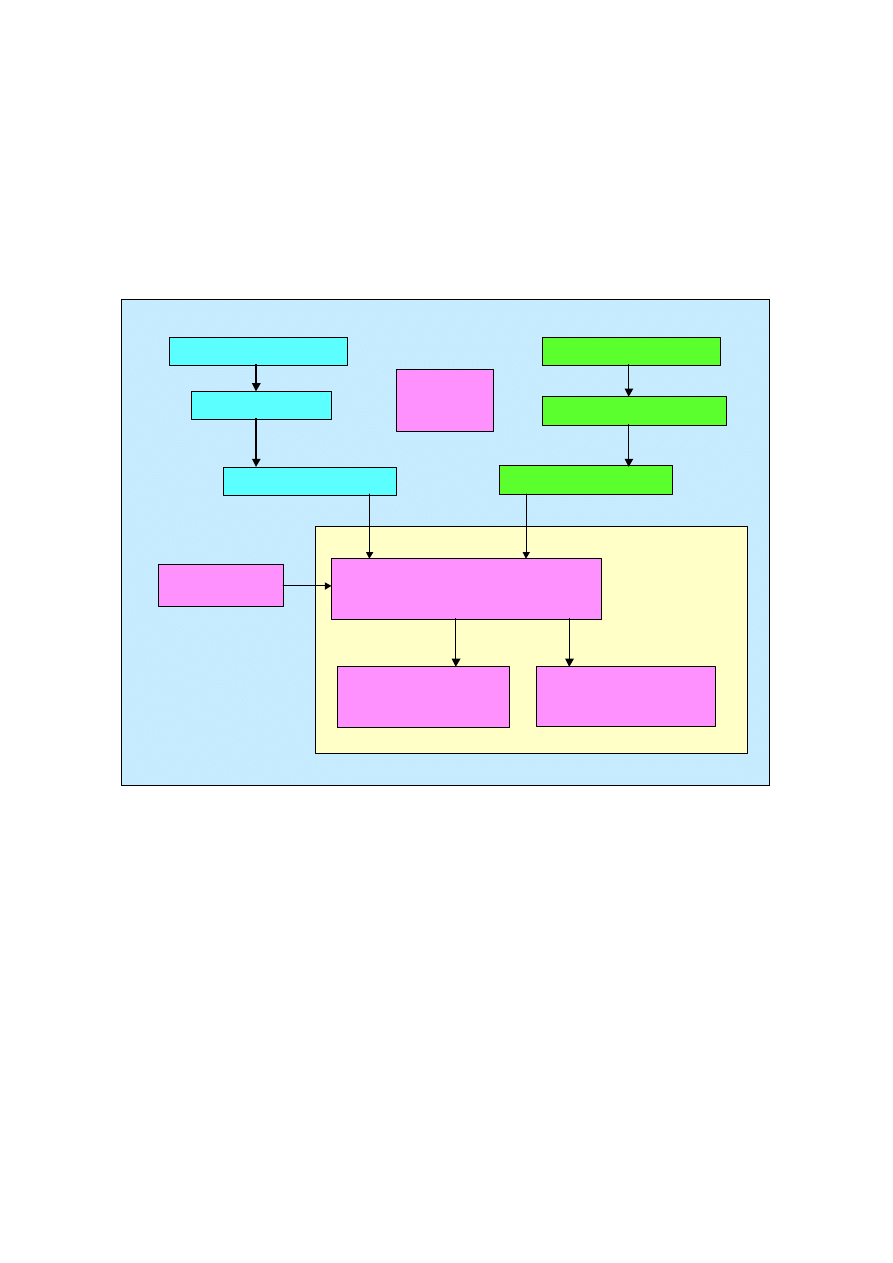
GALILEO Services and Architecture
33
5.2 Management Structure during Development and Validation Phase
In order to ensure an adequate flow of information and effective political control by Member States,
the European Union has established a Supervisory Board composed of representatives of the EU
Member States, and similarly the Programme Board on Satellite Navigation (PB-NAV) has been
entrusted with the supervision of ESA’s participation in the Joint Undertaking.
The bodies of the Joint Undertaking are the Administrative Board, the Executive Committee and the
Director.
Joint Undertaking
Administrative Board
Advisory
Committee
Joint Undertaking
Executive Committee
Joint Undertaking
Director
ESA Member States
PB-NAV
ESA Representative
EU Member States
Supervisory Board
EC Representative
Organs of the
Joint Undertaking
Security
Board
Joint Undertaking
Administrative Board
Advisory
Committee
Joint Undertaking
Executive Committee
Joint Undertaking
Director
ESA Member States
PB-NAV
ESA Representative
EU Member States
Supervisory Board
EC Representative
Organs of the
Joint Undertaking
Security
Board
Figure 6 Joint Undertaking Set-up
The Administrative Board, composed of the members of the JU, is the decision taking body
necessary for implementing the programme and for exercising overall supervision of the
programme execution. It is assisted in the preparation of its decisions by the Executive Committee,
while the Director is the chief executive responsible for the day-to-day management.
A Security Board decides on security related matters to be executed by the Joint Undertaking.
The Joint Undertaking ensures that the development and validation phase activities are constantly
assessed with respect to the mission requirements and public and private needs for the deployment
and exploitation phase.

GALILEO Services and Architecture
34
Annex 1:
Acronyms and abbreviations.
AOC
Advanced Operational Capability
ARNS
Aeronautical Radio Navigation System
ASQF
Application Specific Qualification Facility
BER
Bit Error Rate
BOC
Binary Offset Carrier
bps
Bits per second
CS Commercial
Service
DVP
Development Verification Platform
EC European
Commission
ECAC
European Civil Aviation Conference
EGNOS
European Geo-stationary Navigation Overlay Service
ELT
Emergency Location Terminals
EMCA
European Maritime Core Area
EOIG
EGNOS Operators and Infrastructure Group
E-OTD
Enhanced-Observed Time Difference
EPIRB
Emergency Position Indicating Radio Beacon
ERNP
European Radio Navigation Plan
ESA
European Space Agency
EU European
Union
EWAN
EGNOS Wide Area communication Network
FOC
Full Operational Capability
GBAS
Ground Based Augmentation System
GEO GEostationary
Orbit
GEOLUT
GEostationary Orbit Local User Terminal
GLONASS
GLObal Navigation Satellite System
GMDSS
Global Maritime Distress and Safety System
GMES
Global Monitoring for Emergency and Security
GNSS
Global Navigation Satellite System
GNSS-1
Global Navigation Satellite System 1
GNSS-2
Global Navigation Satellite System 2
GOC
Galileo Operating Company
GPS
Global Positioning System
GSC
Galileo Security Committee
GSM
Global System for Mobile communications
GSTB
Galileo System Test Bed
H Horizontal
ICAO
International Civil Aviation Organization
ICC
Integrity Control Centre
ICD
Interface Control Document
IMO
International Maritime Organization
IMO
International Maritime Organization
IMS
Integrity Monitor Station
INS
Inertial Navigation System
IOV
In Orbit Validation
IPR
Intellectual Property Right

GALILEO Services and Architecture
35
ITRF
International Terrestrial Reference Frame
ITU
International Telecommunications Union
IULS
Integrity Up-Link Station
JU Joint
Undertaking
LEOLUT
Low Earth Orbit Local User Terminal
LORAN
Long Range Navigation
LUT
Local User Terminal (SAR receiving station)
Mbps
Megabit per second
MCC
Mission Control Centre
Mcps
Megachip per second
MEO
Medium Earth Orbit
MEOLUT
Medium Earth Orbit Local User Terminal
MHz Megahertz
MRD
Mission Requirements Document
MS Monitoring
Station
MSAS
Multi-functional transport Satellite-based Augmentation System
NLES
Navigation Land Earth Station
NSCC
Navigation Satellite Control Centre
NSE
Navigation System Error
nsec nanoseconds
(10
-9
seconds)
OD&TS
Orbit Determination and Time Synchronization
OS Open
Service
OSS
Orbitography and Synchronization Station
PACF
Performance Assessment and system Check-out Facility
PB-NAV
Programme Board on Satellite Navigation
PRS
Public Regulated Service
RAIM
Receiver Autonomous Integrity Monitoring
RCC
Rescue Coordination Centre
RIMS
Ranging and Integrity Monitor Station
RLSP
Return Link Service Provider
SAR
Search and Rescue
SARPs
Standards and Recommended Practices
SBAS
Satellite Based Augmentation System
SIS
Signal in Space
SoL
Safety of Life
TAI
International Atomic Time
TBC
To be confirmed
TBD
To be determined
TCAR
Third Carrier Ambiguity Resolution
TEN
Trans European Network
TTA
Time to Alarm
TTC
Telemetry, Tracking and Command
UMTS
Universal Mobile Telecommunication System
UTC
Universal Time Co-ordinate
V Vertical
WAAS
Wide-Area Augmentation System
Table 11 Acronyms and abbreviations
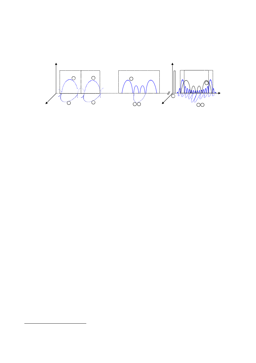
GALILEO Services and Architecture
36
Annex 2: Signals, Frequencies and mapping into services
Signal-In-Space Description
E5A
1575
1278
13
00M
Hz
1164M
Hz
1215M
H
z
12
60M
Hz
1559M
Hz
1591M
Hz
Upper L-Band
Lower L-Band
1176
1207
E5B
E6
L1
E2
E1
FREQUENCY
(MHZ)
IN
PH
A
S
E
IN
QUA
DR
AT
UR
E
1
2
3
4
5
6
7
8
9 10
SAR
DO
W
NL
IN
K
11
L6
E5A
1575
1278
13
00M
Hz
1164M
Hz
1215M
H
z
12
60M
Hz
1559M
Hz
1591M
Hz
Upper L-Band
Lower L-Band
1176
1207
E5B
E6
L1
E2
E1
FREQUENCY
(MHZ)
IN
PH
A
S
E
IN
QUA
DR
AT
UR
E
1
2
3
4
5
6
7
8
9 10
SAR
DO
W
NL
IN
K
11
L6
Figure 7 Galileo Signal in Space Description
Galileo will provide 10 signals in the frequency ranges 1164-1215 MHz (E5A and E5B), 1215-1300
MHz (E6) and 1559-1592 MHz (E2-L1-E1), in the Radio-Navigation Satellite Service (RNSS)
allocated frequency bands. Details are described below.
Four signals will be transmitted in the band 1164-1215 MHz:
• One pair of signals centred on 1176.450 MHz, in the 1164 - 1188 MHz frequency range
(E5A)
21
:
o 1 signal carrying a low data rate navigation message (25 bps), represented by the
signal $
o 1 signal without any data (so-called pilot signal) for increased tracking robustness at
receiver level, represented by the signal %
• One pair of signals centred on 1207.140 MHz, in the 1188 – 1215 MHz frequency range
(E5B)
o 1 signal carrying a navigation message of 125 bps, also supporting integrity and SAR
data, represented by the signal &
o 1 signal without any data (so-called pilot signal) for increased tracking robustness at
receiver level, represented by the signal '
• The signals in E5A and E5B would be generated coherently, therefore giving the possibility
to process them together for (1) increased accuracy, (2) redundancy (to mitigate interference
from DMEs).
The multiplexing scheme of E5a and E5b signals is under study.
Three signals will be transmitted in the band 1260-1300 MHz (E6), centred on 1278.750 MHz.
21
This band, also called L5, will also support GPS modernised signals which, together with Galileo signals will allow
cheap bi-mode GPS/Galileo receivers able to track up to 60 satellites
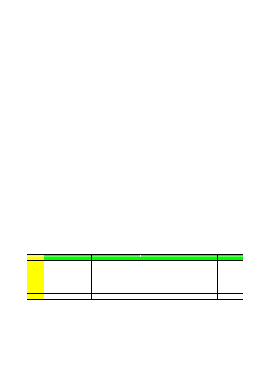
GALILEO Services and Architecture
37
• 1 split-spectrum
22
signal secured through governmental-approved encryption, designed for
governmental applications requiring a continuity of service even in times of crisis,
represented by the signal (
• One pair of signals protected through commercial encryption providing high ambiguity
resolution capabilities for differential applications, among which:
o 1 signal carrying a navigation message of 500 bps supporting value-added data for
commercial purpose, represented by the signal )
o 1 signal without any data (so-called pilot signal) for increased tracking robustness at
receiver level, represented by the signal * by the same waveform than previous
signal
The multiplexing scheme of E6 signals is under study
Three signals will be transmitted in the band 1559-1591 MHz (E2-L1-E1), centred on 1575.42
MHz.
• 1 flexible split-spectrum signal secured through governmental-approved encryption,
designed for governmental applications requiring a continuity of service even in times of
crisis, represented by two different waveforms (signal +)
• One pair of signals
23
, among which:
o 1 signal carrying a navigation message of 100 bps, also supporting integrity and SAR
messages, represented by the signal ,
o 1 signal without any data (so-called pilot signal) for increased tracking robustness at
receiver level, by the signal -, by the same waveform than previous signal
The multiplexing scheme of E2-L1-E1 signals is under study.
Table 12 summarizes all signals characteristics. Data rates are still under consolidation in the frame
of the Galileo design studies carried out by ESA.
Signals id.
Signals
central frequency modulation chip rate
code encryption
data rate
24
data encryption
1
data signal in E5A
1176 MHz
BPSK(10) 10 Mcps
no
50 sps/25 bps
no
2
pilot signal in E5A
1176 MHz
BPSK(10) 10 Mcps
no
no data
no data
3
data signal in E5B
1207 MHz
BPSK(10) 10 Mcps
no
250 sps/125 bps
no
25
4
pilot signal in E5B
1207 MHz
BPSK(10) 10 Mcps
no
no data
no data
5
spilt-spectrum signal in E6
1278 MHz
BOC(10,5) 5 Mcps
Yes – governmental
approved
250 sps/125 bps
yes
6
commercial data signal in E6
1278 MHz
BPSK(5) 5 Mcps Yes - commercial
26
1000 sps/500 bps
yes
22
Split spectrum signals are used for either for selective service denial or interference minimisation between to RNSS
systems sharing the same central frequency carrier
23
This band is already supporting GPS SPS signals, which, together with Galileo signals will allow cheap bi-mode
GPS/Galileo receivers able to track up to 60 satellites.
24
using a 1/2 rate Viterbi convolutional coding scheme
25
A capability of encryption for integrity is envisaged and may be activated pending results on potential market interest
for integrity
26
This encryption may be maintained or removed pending on market analysis results

GALILEO Services and Architecture
38
7
commercial pilot signal in E6
1278 MHz
BPSK(5) 5 Mcps Yes – commercial
27
no data
no data
8
spilt-spectrum signal in L1
1575 MHz
BOC(n,m)
28
m Mcps
Yes – governmental
approved
250 sps/125 bps
yes
9
data signal in L1
1575 MHz
BOC(2,2) 2 Mcps
no
200 sps/100 bps
no
29
10
pilot signal in L1
1575 MHz
BOC(2,2) 2 Mcps
no
no data
no data
Table 12 Galileo signal characteristics
Minimum received power on the ground (by a 0 dBi antenna) would be –158 dBW for each signal
except –155 dBW for signals 5 and 8.
27
This encryption may be maintained or removed pending on market analysis results
28
n and m operational values are the subject of on-going technical trade-o
29
A capability of encryption for integrity is envisaged and may be activated pending results on potential market interest
for integrity

GALILEO Services and Architecture
39
Galileo Services Mapping to Signals
OPEN SERVICES
Open services may consider any of the signals {1,2,3,4,9,10} combination, for instance:
Services
30
. Open
Service
Single Frequency
Open Service
Dual
Frequency
Open Service
Improved
Accuracy
31
Signal number
/
1 (E5a)
X
X
2 (E5a)
X X
3 (E5b)
X
4 (E5b)
X
5 (E6)
6 (E6)
7 (E7)
8 (L1)
9 (L1)
X
X
X
10 (L1)
X X X
Table 13 Mapping Open Service into signals
30
Non bolded crosses correspond to signals selection which would depend on actual applications
31
Either absolute positioning or differential positioning based on Carrier Ambiguity Resolution Techniques such as
TCAR or Wide Lane. Not currently considered in the services performance section

GALILEO Services and Architecture
40
COMMERCIAL SERVICES
Commercial services may consider any of the signals {1,2,3,4,6,7,9,10} combination, for instance:
Services . CS
Value added
CS
Multi carrier differential applications
Signal number
/
1 (E5a)
X
2 (E5a)
X
3 (E5b)
X
4 (E5b)
X
5 (E6)
6 (E6)
X
X
7 (E6)
X X
8 (L1)
9 (L1)
X
X
10 (L1)
X X
Table 14 Mapping Commercial Service into signals

GALILEO Services and Architecture
41
SAFETY OF LIFE SERVICES
SoL services may consider any of the signals {1,2,3,4,9,10} combination, for instance:
Services . SoL
Signal number
/
1 (E5a)
X
2 (E5a)
X
3 (E5b)
X
4 (E5b)
X
5 (E6)
6 (E6)
7 (E6)
8 (L1)
9 (L1)
X
10 (L1)
X
Table 15 Mapping Safety of Life service into signals

GALILEO Services and Architecture
42
PUBLIC REGULATED SERVICES
PRS services would nominally use only the signals 5 and 8:
Services . PRS
Signal number
/
1 (E5a)
2 (E5a)
3 (E5b)
4 (E5b)
5 (E6)
X
6 (E6)
7 (E6)
8 (L1)
X
9 (L1)
10 (L1)
Table 16Mapping Public Regulated Service into signals
GALILEO Services and Architecture
43
Annex 3: EGNOS Coverage Area and Performance
Horizontal
accuracy
16m
Vertical
accuracy
7.7m to
4.0m
Integrity risk
2.10
-7
in
any 150s
Time To Alarm
6s
HAL 40m
VAL
20m to 10m
Continuity 8.10
-5
in
any 150s
Local
Availability
0.99
Figure 8 European Land Masses
Horizontal
accuracy
100-10m 10m
Time To
Alarm
10s 10s
HAL 250-25m
25m
Reliability 3.4.10
-8
/h 3.4.10
-8
/h
Coverage EMCA
Oceanic
waters
(Distance to the
coast greater
than 50NM).
EMCA
Coastal
waters
(Distance to the
coast less than
50NM.)
Figure 9 EMCA (European Maritime Core Area) Waters
0
50
-40
30
60
-40
-30
-20
-10
0
10
20
30
40
20
30
40
50
60
70
-30
-20
-10
0
10
20
30
40
50
25
30
35
40
45
50
55
60
65
70
75

GALILEO Services and Architecture
44
Horizontal
accuracy
220m
Integrity risk
10
-7
/h
Time To Alarm
10s
HAL 0.3NM
Continuity 10
-5
/h
Figure 10 ECAC (European Civil Aviation Conference) Flight Information Regions

GALILEO Services and Architecture
45
Annex 4: Definitions
Accuracy
In the present context, accuracy is a statistical value and is defined as the degree of conformance
between the estimated or measured position and/or velocity and the true position and/or velocity of
the user at a given level of confidence at any given instant time and at any location in the coverage
area.
Accuracy is usually specified as the position error at 95% confidence level. There are several
definitions of position accuracy, each depending on the particular application:
• Predictable: The accuracy of a radio navigation system’s position solution with respect to
the geographic or the geodetic co-ordinates of the Earth.
• Repeatable: The accuracy with which a user returns to a position whose co-ordinates has
been measured at a previous time with the same navigation system.
• Relative: The accuracy with which a user determines one position relative to that of another
position regardless of any error in their true positions.
• Variant: The accuracy with which a user can measure a position relative to that of another
user of the same navigation system at the same time.
A more specific definition, which characterises the positioning system error (instead of the
navigation application error), is the EGNOS definition for accuracy that only takes into account the
error at the output of the user GNSS standard receiver
Alarm Limit
This is the maximum allowable error in the user position solution before an alarm is raised within
the specific time to alarm. This alarm limit is dependent on the considered operation, and each user
is responsible for determining its own integrity in regard of this limit for a given operation
following the information provided by Galileo SIS.
It is often referred to as HAL (Horizontal Alarm Limit) and VAL (Vertical Alarm Limit), and XAL
standing for HAL or VAL.
Availability
Availability of the Navigation Service is the probability that the Positioning service and the
Integrity monitoring service (when applicable) are available and provide the required accuracy,
integrity (when applicable) and continuity performances. The service will be declared available
when accuracy and integrity requirements are met at the beginning of an operation and are
estimated to be met during all the operation period (= continuity requirement).
Availability is a characteristic of the service for all the potential users throughout the lifetime of the
system and then is applied to SIS only.
Continuity risk
Continuity risk is the probability that the system will not provide guidance information with the
accuracy and the integrity required for the intended operation.
Integrity risk
This is the probability during the period of operation that an error, whatever the source, might result
in a computed position error exceeding a maximum allowed value, called Alarm Limit, and the user
not be informed within the specific time to alarm.

GALILEO Services and Architecture
46
RAIM
The Receiver Autonomous Integrity Monitoring (RAIM) is the protection of the navigation solution
provided by this user receiver against position errors exceeding the alarm limit. The integrity
monitor of a user receiver processes the signals received from all visible satellites. As more
satellites than required are available to compute the receiver position, it is possible to identify and
reject erroneous information. The RAIM provides then a timely warning when a failure exists (i.e.
when a position error exceeds the alarm limit). In addition to this, if a user receiver utilises
additional information or measurements from further navigation systems and/or from other sensors,
then the integrity of the navigation solution, which is provided by this user receiver, increases.
Time-to-Alarm
The (System) Time-to-Alarm is defined as the time starting from when an alarm condition occurs to
the time that the alarm is available at the user interface. Time to detect the alarm condition is
included as a component of this requirement.
The start event of an alarm condition is the beginning of a sampling period, in the monitoring
station receiver, during which an erroneous pseudo range will be detected.
Timing accuracy
The Timing Accuracy is related to the accuracy of the navigation solution when used for timing
applications. It measures the difference of the estimated time scale with a reference one. As for the
positioning accuracy, the timing accuracy is also expressed with its statistic, i.e. the 95
th
percentile
of the timing error.
_______________________
Wyszukiwarka
Podobne podstrony:
08 Co Zrobić By Dłużej Się Kochać(bitnova info)
DOD INF SPIS TRESCI INFO
DOD INF SPIS TRESCI INFO
nokia symbian BB5 PPM info by hk2k2(1)
La Dieta South Beach by Dr Arthur Agatston INFO
WinDT 09 [Final] by D@niel part6 INFO
зеркало rutor info Adobe Photoshop CC 2018 v19 1 3 [x86 x64] (2018) PC RePack by D!akov
INF dec5
BEZPIECZE STWO SYSTEM W INF
Sys Inf 03 Manning w 06
Sys Inf 03 Manning w 19
A dane,inf,wiedza,uj dyn stat proc inf w zarz 2008 9
Sys Inf 03 Manning w 02
INF 6 PRZESTEPSTWA
H Bankowość ele platnosci ele proc inf w zzarz 2008 9
Esteron 600 EC
Inf przestrz wekt uklady rown
4 pomiary by kbarzdo
Projekt nr 1, Projekt nr 1 EC przeciwprężna
więcej podobnych podstron