
1
Geodiversity and Geoconservation
by Barbara Dulba and Elżbieta Kania (AGH UST )
You are free to display and print these materials for your personal, non-commercial use, but you may
not otherwise reproduce any of the materials without the prior written consent of the owners. You
may not distribute copies of the materials in any form (including by e-mail or other electronic
means.)
Before you read the text check these words and expressions
essential, quarrying, stretch back to, appreciation, nurture, legislation, designation,
under the auspices, mandatory, notify
History of geoconservation
Conservation of geodiversity is essential and there are numerous threats to geodiversity that need to be
considered, such as unsustainable fossil collecting, coastal erosion, quarrying or infill of disused quarries
and vegetation overgrowth. The concept of geoconservation - the conservation of geodiversity - is new in
most countries, yet Great Britain has had a framework for protecting geological resources that has been in
place for more than 50 years, with roots that stretch back to the late nineteenth century.
There are many documented examples of measures to protect geological sites from the early 1800s
onwards. During the 1800s and early 1900s there was a strong appreciation that geology was a significant
part of the natural world, supporting and helping to nurture the habitats and wildlife that live upon the
underlying rocks and soils. For example, early examples of protective measures in the United Kingdom
include legislation to protect Salisbury Crags in Edingburgh, and the Cheesewring granite tor in Cornwall.
In the late 1940s the Nature Conservancy started to oversee the designation of the first National Parks in
Britain and the development of the Sites of Special Scientific Interest (SSSI) series. Although geological
features were a component of both designations, the first comprehensive and systematic review of
geological sites in Great Britain was started by the Geological Conservation Review (GCR) in 1977, under
the auspices of Nature Conservancy Council (NCC). However, it was not until the Wildlife and
Countryside Act (1981) that it became mandatory for the NCC to notify landowners, in addition to local
planning authorities, of geological sites on their land.
Beyond the UK, the geological importance of the volcanic landscape of Siebengebirge, Germany was
recognised in its designation as the first geological nature reserve in 1836. Early geoconservation efforts
were also seen in the USA. In 1864 Yosemite Valley in California became a protected area, which was
closely followed by the designation of the world's first national park at Yellowstone. The main reason for
its designation was to protect its 'natural curiosities and wonders', thus preserving the features of
geothermal interest in their natural condition.
SOURCE
http://www.geoconservation.com/HOG.htm

2
Geodiversity and Geoconservation
by Barbara Dulba and Elżbieta Kania (AGH UST )
You are free to display and print these materials for your personal, non-commercial use, but you may
not otherwise reproduce any of the materials without the prior written consent of the owners. You
may not distribute copies of the materials in any form (including by e-mail or other electronic
means.)
Ex. 1 Choose some of the words from the box to replace the words in bold.
1. It is obligatory to report any finds of value to the authorities.
2. The Yosemite Valley national park came into being under the patronage of Lincoln, who signed
the first bill granting its special rights.
3. It is crucial to preserve not only bio- but also geodiversity.
4. There has been more and more understanding of its importance.
5. It is stupid to cultivate your grudges.
Ex.2 In the text there are words with prefix over- and under. Use them with other words and make
examples to show their meaning.
DEVELOPED, COOKED, RATED, ESTIMATED, PRICED, HEADS,
Ex.3 Check the abbreviations in the text.
SSSI, GCR, UK, USA, NCC
Ex. 4 A Scan the text to find out what happened :
1. in1864
2. between 1800 and 1900
3. in 1836
4. in 1977
5. in the late 1940ties
B Do you know how to talk about times and dates? Use the expressions in the box with correct
preposition of time. Make true sentences about yourself with some of them.
Long lazy afternoon, May, Friday, noon, the weekend, Middle Ages, the summer,
lectures, 1June, 1987, Monday morning, bright Christmas day the summer/2/ the
morning, midnight, Easter, the afternoon, dawn, the day of my
AT…………………………………………………………………..…………..
IN……………………………………………………………………………………..……

3
Geodiversity and Geoconservation
by Barbara Dulba and Elżbieta Kania (AGH UST )
You are free to display and print these materials for your personal, non-commercial use, but you may
not otherwise reproduce any of the materials without the prior written consent of the owners. You
may not distribute copies of the materials in any form (including by e-mail or other electronic
means.)
ON………………………………………………………………………………………....
DURING…………………………………………………………………………………..
C What do these expressions mean? Check and use in sentences of your own.
at the turn of the century, in the early, mid, late 20ties, twenty years on, B.C., A.D.,
nowadays, currently, in those times, at the time of, on the eve of…, once, then, back then, once
upon a time, since times immemorial, for ages, as long as I can remember, in pre-school times,
once in a blue moon, from times immemorial

4
Geodiversity and Geoconservation
by Barbara Dulba and Elżbieta Kania (AGH UST )
You are free to display and print these materials for your personal, non-commercial use, but you may
not otherwise reproduce any of the materials without the prior written consent of the owners. You
may not distribute copies of the materials in any form (including by e-mail or other electronic
means.)
Conservation principles for geology
Before you read the text check the meaning of the following words and expressions
outcrop- ........................., integrity-...................., depletion- .........................,pits……………………..
karst- …………………, finite- ......................... , removal-............................, approach-......................
generic- ………………., hence-……………….., features-……………….., extensive-……………….
match column A with column B:
A
B
FUNDAMENTAL
MAIN
ADVERSE
HOLISTIC
DISTINCTIONS
MAINTAIN
EXTENSIVE
ROBUST
AIM
NEGATIVE
WHOLE
OBJECTIVE
SUSTAIN
STRONG
DIFFERENCES
KEY
WIDESPREAD
ESSENTIAL

5
Geodiversity and Geoconservation
by Barbara Dulba and Elżbieta Kania (AGH UST )
You are free to display and print these materials for your personal, non-commercial use, but you may
not otherwise reproduce any of the materials without the prior written consent of the owners. You
may not distribute copies of the materials in any form (including by e-mail or other electronic
means.)
The Earth Science Conservation Classification (ESCC) has been used since 1990 by all of the UK
statutory conservation agencies to classify geological sites.
The ESCC was revised in 2003 in the light of practical experience in using the original classification. The
revised ESCC has sixteen site types organised into three major categories in contrast to the eleven site
types and two major categories of the original classification.
Table 1
(see below) compares the old and
new classifications.
The three main categories are exposure or extensive, finite and integrity. The distinctions between the
three main categories are important, reflecting very fundamental differences in conservation strategies. The
classification allows generic threats and conservation strategies to be defined for the different site types.
Exposure or extensive sites contain geological features which are relatively extensive beneath the surface.
The basic principle is that removal of material does not cause depletion or damage to the resource, as new
material of the same type is being freshly exposed as material is removed. The main management aim is to
achieve and maintain an acceptable level of exposure of the interest features. Site types include active
quarries and mines, disused quarries, rail and road cuttings, coastal cliffs and foreshore, inland outcrops
and extensive buried interest sites.
Finite sites contain geological features that are limited in extent so that removal of material may cause
depletion of the resource. The features are often irreplaceable if destroyed. The basic management
principle is to permit responsible scientific usage of the resource while conserving it in the long term .
Hence, it is often necessary to implement controls over removal of material. Site types include many
mineral and some fossil deposits, mine dumps, finite underground mines and finite buried interest sites.
Integrity sites are geomorphological and are characterised by the need for holistic management. Damage
to one part of a site may adversely affect the site as a whole. In the case of active process sites, the
fundamental principle is to maintain the active processes by non-interference as far as possible. Site types
include active and static geomorphological sites, caves and karst.
The importance of distinguishing between these three groups is that their successful management usually
requires a quite different approach. As a rule, exposure sites are more robust than integrity or finite sites
and can often tolerate the effects of human activities to a greater degree.
The site categories are not mutually exclusive and there are numerous examples where part of a site is
classified as exposure and another part is classified as finite or integrity. For example, a stratigraphic
sequence in a cliff or quarry would have an exposure classification, as removal of rocks would generally
produce further exposure of the same material. However, mineral veins within the same sequence would
often have a finite classification, as removal of vein material would not produce fresh exposure, but would
result in loss of the interest.

6
Geodiversity and Geoconservation
by Barbara Dulba and Elżbieta Kania (AGH UST )
You are free to display and print these materials for your personal, non-commercial use, but you may
not otherwise reproduce any of the materials without the prior written consent of the owners. You
may not distribute copies of the materials in any form (including by e-mail or other electronic
means.)
Table 1
Original Classification
Revised Classification
Exposure Sites
Exposure or Extensive Sites
Active quarries and pits
EA Active quarries and pits
EA
Disused quarries, pits and cuttings
ED Disused quarries and pits
ED
Coastal and river cliffs
EC Coastal cliffs and foreshore
EC
Foreshore exposures
EF River and stream sections
EW
Inland outcrops and stream sections EO Inland outcrops
EO
Mines and tunnels
EM
Exposure underground mines and
tunnels
EU
Extensive buried interest
EB
Road, rail and canal cuttings
ER
Integrity Sites
Integrity Sites
Static (fossil) geomorphological
IS Static (fossil) geomorphological
IS
Active process geomorphological
IA Active process geomorphological
IA
Caves and karst
IC Caves
IC
Karst
IK
Finite Sites
Unique mineral, fossil or other
geological
IM
Finite mineral, fossil or other
geological
FM
Mine dumps
ID Mine dumps
FD
Finite underground mines and
tunnels
FU
Finite buried interest
FB
SOURCE
http://www.naturalengland.org.uk/ourwork/conservation/geodiversity/protectandmanage/conservation.aspx

7
Geodiversity and Geoconservation
by Barbara Dulba and Elżbieta Kania (AGH UST )
You are free to display and print these materials for your personal, non-commercial use, but you may
not otherwise reproduce any of the materials without the prior written consent of the owners. You
may not distribute copies of the materials in any form (including by e-mail or other electronic
means.)
Ex 1 There are passive structures highlighted throughout the text. Look at the other, underlined fragments
and change them into passive. Decide whether the passive structure is better or not.
1. The old and the new…………………………………………
2. The principle is that the depletion or damage…………..….
3. The depletion of the resource………………………..……..
4. The basic management principle is for responsible scientific usage……………………… while
it……………………...
5. Hence, it is often necessary for controls over removal of material…………………………
6. The site as a whole………………………………. by damage to one part of a site...
7. As a rule, exposure sites are more robust than integrity or finite sites and the effects of human
activities………………………………..… to a greater degree.
8. ..as further exposure of the same material …………………….. with the removal of rock
Ex.2 In groups of three learn one of the classifications of site types. Give yourselves up to five minutes
then tell the others what you remember.
Ex.3 Provide the missing word forms.
VERB
NOUN
ADJECTIVE
CLASSIFY
CONSERVE
………………………
SUSTAIN
ACCEPT
……………………….
…………………………….
…………………………….
…………………………….
……………………………
……………………………
DIFFERENCE
………………………….
…………………………..
EXTENSIVE
…………………………..
…………………………..
………………………….

8
Geodiversity and Geoconservation
by Barbara Dulba and Elżbieta Kania (AGH UST )
You are free to display and print these materials for your personal, non-commercial use, but you may
not otherwise reproduce any of the materials without the prior written consent of the owners. You
may not distribute copies of the materials in any form (including by e-mail or other electronic
means.)
Ex.4 match column A with column B to make collocations
A
B
GEOMORPHOLOGICAL
MAIN
SITE
GEOLOGICAL
FOSSIL
MUTUALLY
NUMEROUS
UNDERGROUND
DISUSED
COASTAL
MINE
EXCLUSIVE
TYPE
DUMPS
QUARRIES AND PITS
TUNNELS
SITE
EXAMPLES
AIM
DEPOSITS
FEATURE
CLIFFS

9
Geodiversity and Geoconservation
by Barbara Dulba and Elżbieta Kania (AGH UST )
You are free to display and print these materials for your personal, non-commercial use, but you may
not otherwise reproduce any of the materials without the prior written consent of the owners. You
may not distribute copies of the materials in any form (including by e-mail or other electronic
means.)
Geodiversity
Try to answer the following questions without reading the text below. The use them as suitable headings
for the following paragraphs.
How does geodiversity underpin the landscape?
What is geodiversity?
Why is geodiversity important?
Why is soil such an important aspect?
……………………………………………….…..
In simple terms, geodiversity is the variety of rocks, minerals, fossils, soils, landforms and natural
processes.
………………………………………………………….
Rocks, fossils and minerals have been formed over millions of years and represent unique past
environments and events. The landforms around us have been produced over hundreds of thousands of
years and soils may take several thousand years to form. The information provided by geodiversity helps
us to understand how our planet has changed over time and how life evolved.
………………………………………………………….
It forms the thin living layer of our geodiversity, linking the underlying geology with the land surface and
atmosphere. It is a complex and diverse natural resource that is fundamental to life on earth. It reflects the
complex relationship between geology, landform, climate and land use.

10
Geodiversity and Geoconservation
by Barbara Dulba and Elżbieta Kania (AGH UST )
You are free to display and print these materials for your personal, non-commercial use, but you may
not otherwise reproduce any of the materials without the prior written consent of the owners. You
may not distribute copies of the materials in any form (including by e-mail or other electronic
means.)
…………………………………………………
Geodiversity is all around us. It provides the raw materials for building, the fuel we put in our cars and the
soils in which our crops grow. It also produces the spectacular landscapes we visit on holiday and the
countryside we see every day.
Source:
http://www.naturalengland.org.uk/ourwork/conservation/geodiversity/default.aspx
Conserving geodiversity
Abiotic
Heritage
Remit
Designated
Policy
Gather momentum
Diversity
Range– locate the above in the text to see what they refer to. Translate the entire sentences.
Special guest editorial by Tim Holt-Wilson
Conserving geodiversity is part of the core business of nature conservation. Geodiversity is essentially the
abiotic part of the natural world, and may be defined as the natural range or diversity of geological and
geomorphological features, soil and water that compose and shape the physical landscape.
Earth heritage resources have been exploited by humans for many thousands of years, but the integrity and
accessibility of these resources may be threatened in various ways. Geodiversity Action Plans (GAPs)
provide a new comprehensive approach to conserving Earth heritage. The statutory conservation of
geodiversity features is part of the remit of National Parks, National Nature Reserves and Sites/Areas of
Special Scientific Interest. The non-statutory conservation of geo-sites is carried out under Local Sites

11
Geodiversity and Geoconservation
by Barbara Dulba and Elżbieta Kania (AGH UST )
You are free to display and print these materials for your personal, non-commercial use, but you may
not otherwise reproduce any of the materials without the prior written consent of the owners. You
may not distribute copies of the materials in any form (including by e-mail or other electronic
means.)
designation procedures, notably Regionally Important Geological / geomorphological Sites (RIGS). Areas
with significant concentrations of geo-features may be designated as European Geoparks.
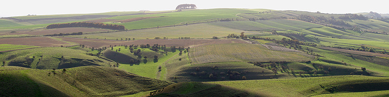
The Wiltshire Downs at Cherhill: A landscape of dry valleys developed in the Lower Chalk escarpment.
Photo © TD Holt-Wilson
UK planning policies give some protection to geodiversity outside the network of designated sites and
areas. In England, Planning Policy Statement 9: Biodiversity and Geological Conservation (PPS9) views
the delivery of geoconservation as one of the objectives for sustainable development, nature conservation
and social renewal. Elements of physical landscape may be conserved through landscape characterisation
at different levels of detail. Official action to conserve soils is beginning to gather momentum in the UK,
while groundwater and surface water conservation is already well advanced. However, geoconservation is
not just the business of specialised agencies and interest groups, and is being carried out on an everyday
basis by a range of parties who manage the countryside. New digital technologies have great potential for
mapping geo-features for conservation purposes, and for communicating them to a wider public. A wide
range of paper-based and online resources are available giving advice on geodiversity, geoconservation
and planning.
SOURCE:
http://www.ukwildlife.com/index.php/conserving-geodiversity/
Ex. 1 Translate the following phrases into English
1. Dostępność zasobów accessability of resources
2. Jeden z celów one of the objectives
3. Jest już mocno zaawansowany is already well advanced
4. Wykorzystywany przez ludzi exploited by humans
5. Prowadzona na co dzień carried out on a daily basis
6. Sieć wyznaczonych lokalizacji network of designated sites
7. Może być zdefiniowana jako may be defined as
Ex.2 Find out what is done in Poland in terms of geoconservation. Find out about sites being actually
under protection. Give a short talk about some examples of inanimate nature monuments.

12
Geodiversity and Geoconservation
by Barbara Dulba and Elżbieta Kania (AGH UST )
You are free to display and print these materials for your personal, non-commercial use, but you may
not otherwise reproduce any of the materials without the prior written consent of the owners. You
may not distribute copies of the materials in any form (including by e-mail or other electronic
means.)

13
Geodiversity and Geoconservation
by Barbara Dulba and Elżbieta Kania (AGH UST )
You are free to display and print these materials for your personal, non-commercial use, but you may
not otherwise reproduce any of the materials without the prior written consent of the owners. You
may not distribute copies of the materials in any form (including by e-mail or other electronic
means.)